La formation des Massifs Alpins
 Francais :
Vous etes à un point de vue fantastique sur la chaine des alpes; en effet, vous pouvez du regard parcourir des centaines de kilometres de relief. votre position est symbolisée par le point bleu sur la carte, et vous avez un regard dans l'axe vers le est / sud est.

A/ Trois étapes de la tectonique de plaques qui a présidé à la formation des Alpes
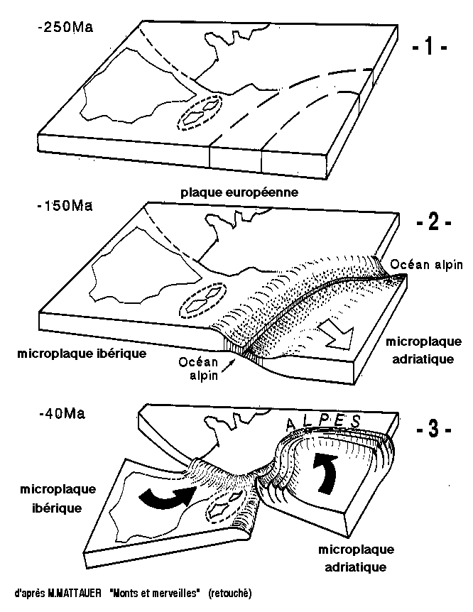
extrait de "Monts et merveilles", p.172, par M. MATTAUER (retouché)
1- début de fragmentation de la plaque européenne (Trias)
2 - Expansion océanique : formation d'un océan alpin étroit (Jurassique supérieur)
3 - Compression (Tertiaire ancien) : collision de la microplaque adriatique avec la plaque européenne (dans le cadre d'un mouvement rotatoire qui concerne aussi la microplaque ibérique)
B/ Résumé très schématique des déformations tectoniques
au cours des deux étapes majeures de l'histoire alpine
(coupe transversale aux Alpes)
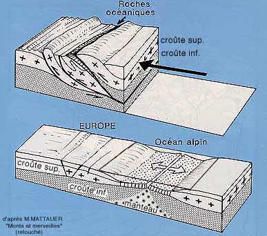
en haut : étape finale, compressive, après collision des bordures continentales
en bas : étape préparatoire, extensive
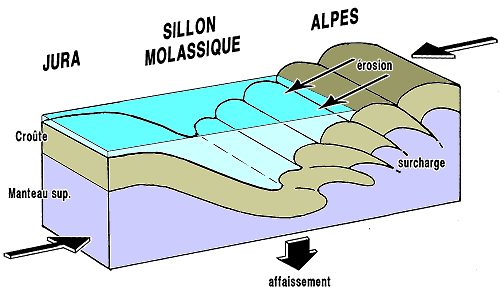
Schéma théorique très simplifié de la formation du sillon molassique périalpin.
en marge externe de la chaîne alpine, sous l'effet de la surcharge induite par les empilements tectoniques liés à la formation de la chaîne.
il s'agit là d'un bel exemple de "bassin flexural", dû à un affaissement de la croûte terrestre par flexion sans rupture (ce qui l'oppose aux bassins d'effondrement par failles, ou "grabens")
(selon le site http://www.geol-alp.com)
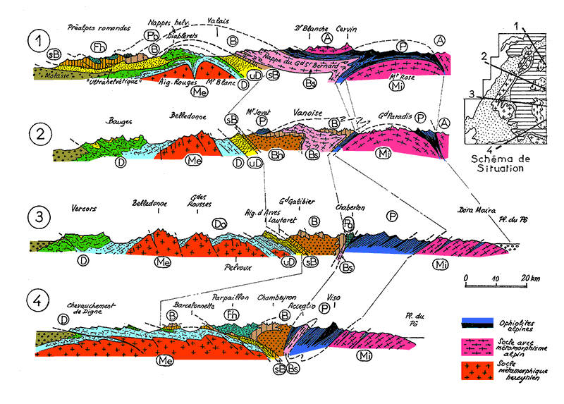
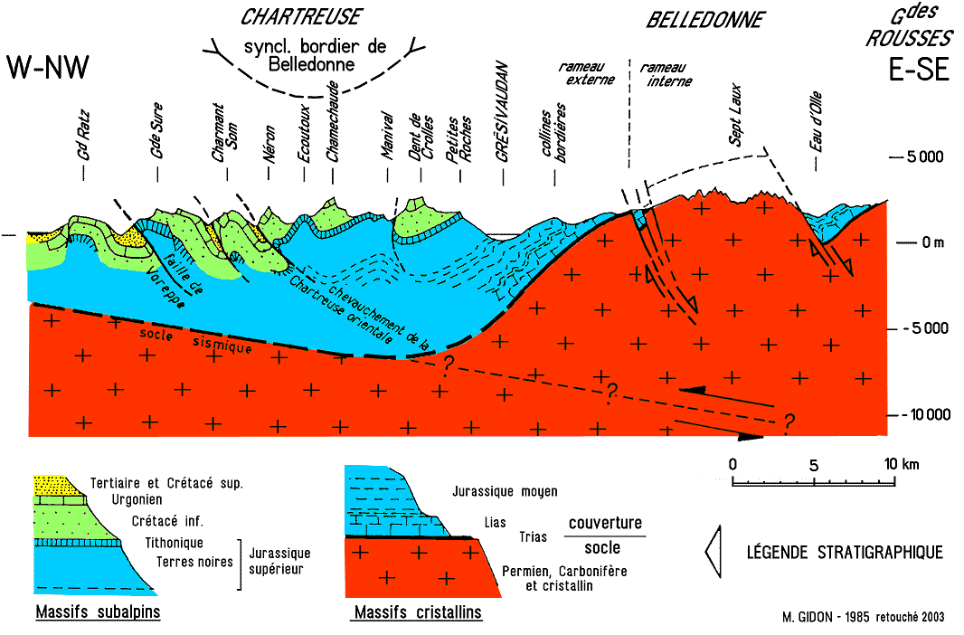
Coupes transversales trés schématisées des Alpes françaises
 Donc de notre point de vue actuel, nous sommes dans un axe 2 / 3.
rappronchons nous un peu pour differencier les trois massifs du vercors, chartreuse, et le belledonne.
 Questions :
d'ici quelle est la position du massif de Belledonne (comment est il placé par rapport aux deux autres)
A quelle période geologique correspond le massif de belledonne ?
Quelle est l'altitude noté sur la table du mont blanc ? Savez vous pourquoi ?
Pour valider votre réponse, merci de m'envoyer un mail avec vos reponses, je vous reponds rapidement pour valider votre reponse.
Une photo du panorama serait un plus pour votre log.
Pas de photo de la table d'orientation par contre merci.
 English :
You are a point of fantastic views of the Alps; in fact, you can look through hundreds of kilometres of terrain. your position is symbolized by the blue dot on the map, and you have a look in the axis to the East / South is.
A / three steps of plate tectonics which presided over the formation of the Alps from 'Mountains and wonders', p.172, by M.
MATTAUER (retouching) 1-beginning of fragmentation of the European plate (Triassic) 2 - seafloor spreading: formation of a narrow Alpine ocean (Upper Jurassic) 3 - Compression (old tertiary): collision of the Adriatic microplate with the European plate (in the context of a rotary movement which also concerns the Iberian microplate)
B / very schematic summary of tectonic deformations in the course of two major stages of alpine history (cross-section to the Alps) up: compressive, final step after collision of continental margins bottom:
top: compressive, final step after collision of continental margins bottom: extensive preparatory step
Theoretical very simplified diagram of the formation of the molasse furrow perialpin. on the outer margins of the alpine chain, under the effect of overload induced by tectonic stacks related to the formation of the chain. It is a fine example of 'flexural basin', due to subsidence of the Earth's crust by bending without breaking (which opposes it the rift by faults basins, or 'grabens')
Sections transverse very summarized French Alps
So from our current point of view, we are in a dimension 2 / 3. approch us a little to differentiate the three massifs du vercors, chartreuse, and the belledonne.
Questions:
from here what is the position of the massif of Belledonne (how is it positioned to the other two) was when geological is the massif of belledonne?
What is the elevation noted on the table of the mont-blanc?
Do you know why?
To validate your response, please send me a mail with your answers, I quickly answer you to validate your response.
A photo of the panorama would be apprecited for your log. No photo of the orientation in contrast table thanks.