ATENÇÃO: Aceder SEMPRE ao local da EarthCache pela base da arriba, quando a maré assim o permitir, COM MUITA ATENÇÃO AO NÍVEL DA MARÉ E AO PISO ESCORREGADIO! NUNCA ACEDER AO LOCAL PELO TOPO DA ARRIBA!
Consultar aqui a previsão das marés para melhor preparar a visita.
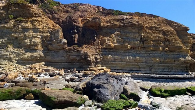
Esta EarthCache pretende dar a conhecer uma estrutura geológica que é desde há longo tempo apelidada de Penedo Mouro pelos habitantes locais, devido à sua cor escura.
Desde criança fui ouvindo diversas histórias sobre a Praia da Ribeira d\'Ilhas e este penedo. Reza a lenda que este pequeno promontório seria utilizado pelos Romanos para a acostagem de embarcações, seguindo depois a pé por uma via pavimentada em direcção a norte. A via existe, é verdade, mas um pouco mais para o interior, atravessando a ribeira dos Cucos na zona de Santo Isidoro. Quanto à sua utilização como cais, tenho sérias dúvidas...
Quanto à natureza geológica do penedo, este é resultado da instalação de um corpo ígneo de origem vulcânica (1), de natureza basáltica (2), no seio da sequência de rochas sedimentares observada nesta região, provavelmente a pouca profundidade. Para além do penedo podem também observar-se outros corpos intrusivos de menor dimensão, recortando as rochas sedimentares das arribas e da plataforma junto ao mar, formando diques, soleiras e outras massas.

É a sua cor negra e o facto de se encontrar proeminente em relação à arriba, devido à maior resistência à erosão, que o tornam peculiar numa paisagem marcada pela abundância de rochas de composição calcária, argilosa e arenosa, de tons amarelados e acinzentados.
1. As rochas vulcânicas (também denominadas de ígneas extrusivas) são rochas que se formam por arrefecimento do magma à superfície ou perto desta. São constituídas por cristais de pequena dimensão e sem forma definida, indestrinçáveis a olho nu, que testemunham o rápido arrefecimento do magma, que não permitiu o pleno desenvolvimento cristalino. Pode também conter grandes quantidades ou ser constituído integralmente de vidro (material amorfo). Por vezes podem conter também cristais de maior dimensão (fenocristais), que se formaram na fase inicial de arrefecimento do magma.
2. O basalto é uma rocha vulcânica, constituída principalmente de plagióclase e piroxenas e, em muitos casos, também olivina. Os basaltos apresentam normalmente cor escura acentuada.

Para registar a visita nesta EarthCache terão de se deslocar até ao Penedo Mouro PELA BASE DA ARRIBA, COM MUITA ATENÇÃO AO NÍVEL DA MARÉ E AO PISO ESCORREGADIO, responder às seguintes questões e enviar-me as respostas por email ou por mensagem através deste site:
a) Na zona W do Penedo Mouro (coordenadas da EarthCache), onde a rocha apresenta cor mais negra, observam-se frequentes fenocristais com dimensão milimétrica a centimétrica na matriz da rocha. Qual a cor mais frequente desses minerais?
b) Qual a direção aproximada do maior comprimento deste corpo intrusivo? N-S, E-W, NW-SE ou NE-SW?
c) Qual é aproximadamente o seu comprimento e largura máximos?
d) Na arriba sobre o penedo existe um corpo intrusivo de dimensão menor. Qual a sua disposição em relação à estratificação? Paralela, oblíqua ou perpendicular?
Pelo caminho podem (e devem!) visitar a EarthCache The Collapse of Ribeira d’Ilhas (GC1KKJQ), também localizada nesta praia.
A partir das orientações de EarthCaching:
Os visitantes não precisam esperar pela permissão para registrar a visita à Earthcache. Deverão enviar as suas respostas e depois registrar o log.
Quando fizer a revisão das respostas, se houver um problema, deve entrar em contacto com o visitante para resolvê-lo. Se não houver nenhum problema, o registo fica simplesmente aceite.

WARNING: ALWAYS access to the site of EarthCache trough the base of the cliff, when the tide allows it. BE VERY CAREFUL WITH THE TIDE AND THE SLIPPERY SURFACE! NEVER ACCESS TO PLACE FROM THE TOP OF CLIFFS!
Consult here the tides prediction to better prepare your visit.
This EarthCache aims to show you a geological structure nicknamed Penedo Mouro by locals, because of its dark colour.
As a child I heard many stories about the Ribeirad\'Ilhas beach and this rock. The legends tell that this small promontory was used by the Romans to docking their boats, thence walk down a paved road heading north. The route exists, it is true, but a little further inland, crossing the Cucos river in Santo Isidoro zone. As for its use as a pier, I have serious doubts...
Regarding the geological nature of the rock, this result from the installation of an igneous body of volcanic origin (1), with basaltic nature (2), within the sequence of sedimentary rocks observed in this region, probably in shallow deep. In addition to this rock you can also look up other smaller intrusive bodies cutting the sedimentary rocks in the cliffs and the platform by the sea, forming dykes, sills and other masses.
Their black colour and the prominence in the cliff, because of the greater resistance to erosion, make it so peculiar in the landscape marked by the abundance of limestones, mudstones and sandstones, with yellowish and grey tones.
1. Volcanic rocks (also called extrusive igneous) are rocks formed by cooling magma at the surface or close to it. They consist of small and formless crystals, indistinguishable to the naked eye, which bear witness to the rapid cooling of magma that did not allow the full crystal development. It may also contain large quantities or consist entirely of glass (amorphous). Sometimes they may also contain larger crystals (phenocrysts) which are formed in the magma’s initial cooling stage.
2. Basalt is a volcanic rock consisting mainly plagioclase and pyroxene and, in many cases, olivine. The basalts typically exhibit sharp dark colour.
To register the visit to this EarthCache you will have to walk to the Penedo Mouro BY THE CLIFF BASE, BE VERY CAREFUL WITH THE TIDE AND THE SLIPPERY SURFACE, answer the following questions and send me the answers by email or message through this site:
a) In the W part of Penedo Mouro (at the coordinates EarthCache), where the rock has darker colour, you can observe several phenocrysts in the rock matrix, with millimeter to centimeter size. What is the most common colour of these minerals?
b) What is the approximate direction of the greatest length of this intrusive body? N-S, E, W, NW-SE or NE-SW?
c) What is approximately its maximum length and width?
d) In the cliffs over the Penedo Mouro there is a smaller intrusive body. What is it disposition towards stratification? Parallel, oblique or perpendicular?
Along the way you can (and should!) visit the EarthCache The Collapse of Ribeira d\'Ilhas (GC1KKJQ), also located on this beach.
From the EarthCaching guidelines:
"People do not need to wait for permission to log your EarthCache. People should send their logging task answers to you, then log your EarthCache.
When you review their logging task answers, if there is a problem, you should contact them to resolve it. If there is no problem, then their log simply stands."
|
Diverte-te com as earthcaches!
A forma mais entusiasmante de aprender algo sobre a terra e os processos que a envolvem é sair para o campo e observar e experimentar em primeira mão o que esta tem para nos mostrar e ensinar. Uma earthcache está associada a um local especial, onde os seus visitantes tomarão contacto com algumas das características geológicas particulares que caracterizam o nosso planeta. Estas caches incluem um conjunto de informação pedagógica que, por exemplo, ajudará os seus visitantes a compreenderem os registos geológicos do nosso planeta, como este é modelado pelos processos geológicos ou como os cientistas recolhem a informação necessária ao estudo da terra.
Poderás aprender maisAQUI (em inglês)
|
 |
Happy earthcaching!
The most exciting way to learn about the Earth and its processes is to get into the outdoors and experience it first-hand. Visiting an Earthcache is a great outdoor activity the whole family can enjoy. An Earthcache is a special place that people can visit to learn about a unique geoscience feature or aspect of our Earth. Earthcaches include a set of educational notes and the details about where to find the location (latitude and longitude). Visitors to Earthcaches can see how our planet has been shaped by geological processes, how we manage the resources and how scientists gather evidence to learn about the Earth.
To find out more click HERE.
|