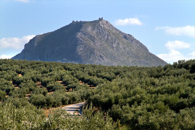
Este gigante rocoso culminado por los restos de un castillo Calatravo del siglo XIII nos anuncia que la ciudad de Martos está cerca ya que se puede apreciar con claridad desde 40-50 km de distancia.
Según algunos historiadores este coloso podria ser una de las dos columnas de Hércules junto al Peñon de Gibraltar.
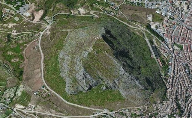
La Peña de Martos se visualiza como una gran mole rocosa con forma troncocónica, tiene una superficie total de 60.3407 HAS. La imagen que presenta, desde su cara norte, simula la cabeza de un dragón. Es un bloque rocoso desenraizado, también llamado olistolito, lo que viene a significar roca sola.
La Peña y el resto del término municipal de Martos pertenecen a la Cordillera Bética, esta Cordillera presenta tres unidades estructurales:
a) zona sub bética, donde se encuentra la Sierra Caracolera.
b) el dominio intermedio, donde se sitúan La Peña y la Sierra de la Grana.
c) la depresión del Guadalquivir, por donde se extiende casi todo el término municipal de Martos.
El profesor Nieto Albert indica que La Peña se forma durante el Jurásico, hace unos 205 millones de años. Está constituida por calizas y dolomías igual que su vecina Sierra Caracolera. Se supone que es un bloque de roca que se desmenbró de la Sierra de la Caracolera. En su base hay un gran lecho de tierra arcillosa.
¿Pero como se formó esta enorme montaña?.
Para responder a esta cuestión hay que comenzar por explicar que son las dolomías:
La dolomía es una roca sedimentaria de origen químico compuesta básicamente de dolomita, cuya composición química es carbonato de calcio y magnesio.
Fué distinguida de la caliza por el geólogo francés D. Dolomieu en el siglo XVIII. La dolomía debe contener al menos 50% de dolomita; si contiene menos es una caliza dolomítica.
Se considera pura cuando ese porcentaje pasa del 90%.
Es una roca grisácea (también puede ser blanca ó rosada) y porosa, muy común.
Se encuentra en capas espesas de centenares de metros y puede también formar macizos enteros, como los Alpes Dolomíticos (Tirol).
Suele ser el resultado del reemplazamiento metasomático de calcitas no cementadas en aguas poco profundas.
No obstante, la llamada dolomía primaria se ha formado por precipitación directa de la dolomita. Se originan también por la sedimentación de caparazones de organismos del plancton marino en los océanos.
La dolomía aparece en vetas minerales hidrotermales.
La altura de esta dolomia teniendo en cuenta que la ciudad está a 720m sobre el mar y el punto más alto de la peña es de 996m es de 270-280m de altura.
Para poder registrar este earthcaché deberás subir hasta el punto más alto de la Peña y enviarnos por correo las respuestas a las siguientes preguntas:
¡¡¡ No revelar informacion de las respuestas en los logs !!!
¡¡¡ Logs que no cumplan estos requisitos seran borrados en un plazo no superior a 48 horas !!!
1. Durante la subida encontraras un banco, justo detras hay una gran roca ¿de color es la roca y que tipo de tacto tiene?
2. En las coordenadas del GZ (interior del castillo) ¿cuantas paredes de roca se mantien en pié?
3. Desplazate a las coordenadas llamadas "FOSO" que aparecen en la ficha y calcula que ancho tiene dicho foso.
4. Desplazate a las coordenadas "TORRE" que aparecen en la ficha y colocandote en el centro de ella calcula que altura aproximada tiene la torre en la parte derecha y en la parte izquierda.
5. Sería recomendable pero no obligatorio que mostraran una fotografía hecha desde el GZ con su GPS o sin él y la adjuntaran al hacer el log.
![]()

This giant rock capped by the remains of a thirteenth century castle Calatravo announces that the city of Martos is close as can be seen clearly from 40-50 km away.
According to some historians this colossus could be one of the pillars of Hercules with the Rock of Gibraltar.
Peña de Martos is displayed as a truncated cone-shaped rocky mass, it has a total area of 60.3407 HAS. The image presented, from its north face, simulates the head of a dragon. It is a rocky block uprooted, also called olistolito, which comes to mean lonely rock.
La Peña and the rest of the municipality of Martos belong to the Betic, this Cordillera has three structural units:
a) subbética area where there is the Sierra Caracolera.
b) the intermediate domain where the Rock and the Sierra de la Grana is located.
c) depression of the Guadalquivir, where most of the town of Martos extends.
Professor Albert Nieto indicates that the sentence is formed during the Jurassic, about 205 million years ago. It consists of limestones and dolomites Like its neighbor Sierra Caracolera. It is supposed to be a block of rock broken of the Sierra de la Caracolera. At its base is a large bed of clay.
But as this huge mountain was formed ?
To answer this question we must begin by explaining that are the Dolomites:
Dolomite is a sedimentary rock of chemical origin composed mainly of dolomite, whose chemical composition is calcium carbonate and magnesium.
It was distinguished from the limestone by the French geologist D. Dolomieu in the eighteenth century. Dolomite must contain at least 50% of dolomite; if it contains less it is a dolomitic limestone.
It is considered pure when the percentage is more than 90%.
It is a very common gray rock (can also be white or pink) and porous.
It is found in thick layers of hundreds of meters and can also form clumps whole, as the Dolomites (Tirol).
Usually the result of metasomatic replacement of calcite uncemented in shallow water.
However, primary call dolomite is formed by direct precipitation of dolomite. They also arise from the sedimentation of shells of marine plankton organisms in the oceans.
It appears in hydrothermal dolomite mineral veins.
The height of this dolomite considering that the city is 720 meters above the sea and the highest point of the rock is 996 meters is 270-280 meters high.
To register this EarthCache you must climb to the highest point of the Rock and send by email the answers to the following questions:
¡¡¡ Do not reveal answers in your logs !!!
¡¡¡Logs not complying these requirements will be deleted within a time limit no more than 48 h!!!
1. During the climb you will find a bench, just behind you can find a big rock tell me the color of this rock and identifies what kind of touch has?
2. In the coordinates of GZ see your GPS and tell me how many wall rock are around you?
3. Go to the coordinates called "FOSO" that appear on this geocache width is estimated that pit.
4. Go to the coordinates called "TORRE" that appear on this geocache and placing you in the center of her approximate height is estimated that the tower on the right and on the left side.
5. It would be recommended but not required to show a picture taken from the GZ with or without GPS and attach them to do the log.
¡¡¡ Deseamos que el esfuerzo realizado para subir hasta la cumbre os sea recompensando pudiendo disfrutar de las increibles vistas que hay desde la cima tanto de la ciudad de Martos como del resto de la comarca, un saludo !!

PRIMER EARTH CACHÉ PUBLICADO EN LA PROVÍNCIA DE JAÉN COMO MOTIVO DE NUESTRO SEGUNDO ANIVERSARIO.