“PRAÍNHA” DIKES
[Santa Maria – Açores]
EARTHCACHE

PORTUGUÊS

Santa Maria
“A ilha de Santa Maria pertence ao grupo Oriental do arquipélago dos Açores, do qual fazem também parte a ilha de São Miguel e os ilhéus das Formigas; está localizada entre os 37º01´16’’ (ilhéu das Lagoinhas) e 36º55’37’’ (Ponta da Malbusca) de latitude norte e os 25º11’27’’ (Ponta do Carneirinho) e 25º00’49’’ (Ponta das Eirinhas) de longitude oeste.
Santa Maria é ilha mais ”velha” dos Açores, remontando as lavas mais antigas a uma idade superior a 10 milhões de anos.
Ao contrário do que é voz corrente nas ilhas, Santa Maria é de natureza vulcânica.Contudo, a sua idade elevada, comparativamente às restantes ilhas do arquipélago, determina que as formas vulcânicas originais estejam já muito degradadas e sejam de difícil reconhecimento. Em virtude do forte levantamento sofrido pela ilha desde finais do Pliocénico, Santa Maria é a única ilha dos Açores onde se encontram expostas importantes sequências rochosas vulcânicas e sedimentares (fossilíferas) de génese submarina. Estas permitem reconstituir uma história complexa de variações relativas do nível do mar que abrange os últimos 10-8 milhões de anos (Ma) da história do Atlântico NE.
A ilha emergiu no Miocénico (há aproximadamente 10-8 Ma), sendo a mais antiga do arquipélago. A atividade vulcânica estendeu-se até ao Pliocénico (há aproximadamente 2 Ma), com fases alternadamente subaéreas e submarinas, efusivas e explosivas. As sequências sedimentares, intercaladas nas séries vulcânicas, ou sobrepostas àquelas, datam do Miocénico final (≈5,5 Ma) até ao Quaternário (menos de 130.000 anos?).
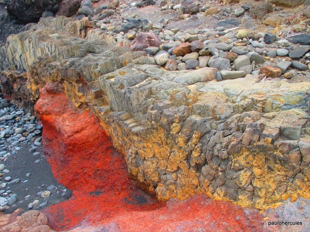
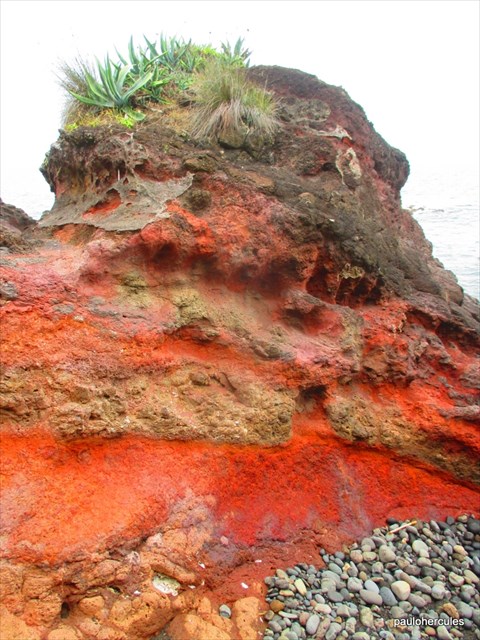
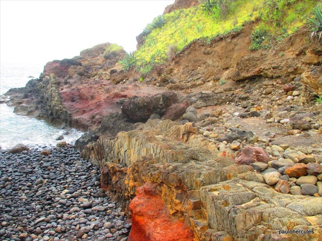
Do ponto de vista vulcanológico, ressalta, em Santa Maria, a ocorrência de abundantes afloramentos de piroclastos e de derrames basálticos submarinos (lavas em almofada), particularmente ao longo do litoral (com exceção da costa oeste), desde o Figueiral até à Cré. Este tipo de materiais não se encontra exposto em nenhuma outra ilha açoriana, por se encontrarem cobertos por lavas subaéreas mais recentes ou abaixo do nível do mar atual.
A existência de indícios de praias elevadas àquelas altitudes significa que Santa Maria subiu (ou está ainda em processo de soerguimento) relativamente ao atual nível das águas do mar. Outro dado que atesta o levantamento da ilha de Santa Maria é a abundante ocorrência de lavas em almofada (“pillow-lavas”) a diversas altitudes. Como estas lavas se formam sempre debaixo de água, a sua observação por vezes a mais de 100 m de altitude implica o levantamento isostático acentuado da ilha de Santa Maria relativamente aos fundos marinhos em que assenta, uma vez que durante os últimos 5 milhões de anos o nível das águas do mar terá estado, no máximo, cerca de 50 m acima do atual”.
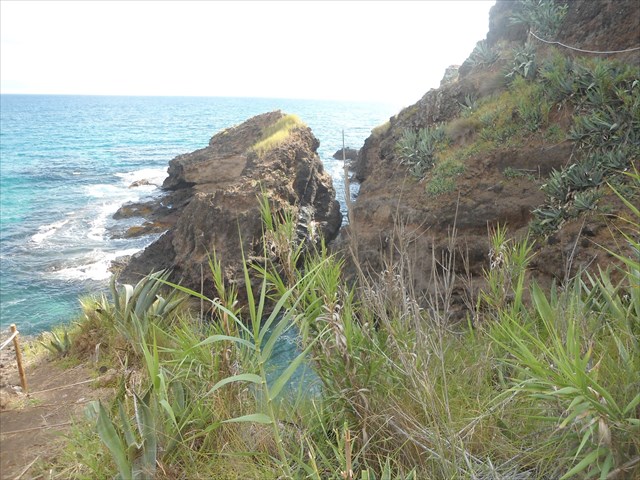
OS FILÕES
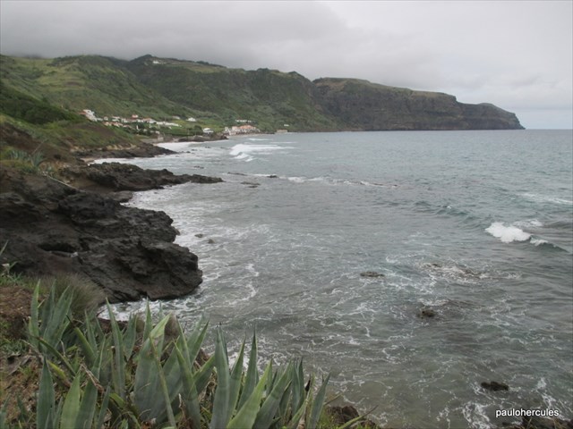
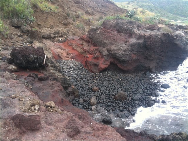
Os filões são corpos magmáticos, de forma tabular, resultantes do preenchimento de fraturas existentes nas rochas. A sua atitudee dimensões são variáveis, podendo apresentar espessuras que variam entre poucos milímetros (filonetes) a alguns metros ou mesmo quilómetros e extensões desde alguns metros até quilómetros. A sua espessura nem sempre é constante e por vezes ramificam-se. Observam-se, frequentemente, variações texturaise mineralógicas num mesmo filão.

FILÕES DE QUARTZO
Nas fraturas podem circular soluções aquosas quentes (fluidos hidrotermais), de origem magmática ou outra, permitindo a precipitação de minerais que, assim, constituem os chamados filões hidrotermais. Estes são, em geral, consideravelmente mais longos que espessos (tipicamente, 100 a 1000 vezes). A circulação de fluídos enriquecidos em sílica permite a formação de filões e filonetes de quartzo, sobretudo no granito do Gerês. Eles encontram-se, por vezes, a preencher zonas de falha. O movimento ao longo da falha provoca esmagamento do material silicioso, dando-lhe, dessa forma, um aspeto de brecha. Ao quartzo associam-se, por vezes, óxidos de ferro ou sulfuretos disseminados.
FILÕES E MASSAS DE PEGMATITOS, APLITOS E APLITO-PEGMATITOS
Os filões e massas de aplitos e pegmatitos representam a porção mais hidratada e de cristalização mais tardia de um magma. Nos últimos estádios da cristalização magmática os magmas residuais são enriquecidos em voláteis tais como água, flúor e boro. Podem ainda conter outros elementos químicos que não entraram na estrutura dos minerais já formados e que, por isso, se concentraram neste magma residual, tais como Be e Sn, entre muitos outros. Como resultado disso, a partir do magma residual podem cristalizar minerais raros em que estes elementos são constituintes essenciais, tais como berilo (silicato de alumínio e berílio), cassiterite (óxido de estanho), topázio (silicato de alumínio e flúor) e turmalina (silicato complexo com boro, ferro e sódio). Os pegmatitos e aplitos têm composições muito diversas, mas a maioria tem composição granítica, com quartzo, feldspato potássico e albite, designando-se então de pegmatitos graníticos. Num mesmo filão pode coexistir preenchimento aplítico e pegmatítico, com a porção pegmatítica na zona central e uma zona aplítica na periferia ou vice-versa.
FILÕES DE ROCHAS BÁSICAS
|
Magmas de composição básica também preenchem, frequentemente, fraturas nas rochas graníticas, originando filões com uma coloração escura que é devida à abundância de minerais ferromagnesianos (como piroxena, anfíbola, biotite, etc…). A sua textura é claramente mais fina do que a de rochas ígneas plutónicas, como os granitos. Tal deve-se ao facto da sua cristalização, embora tendo lugar em profundidade, ser mais rápida do que nos granitos. Na verdade, os magmas de natureza básica, ao arrefecerem, iniciam a sua cristalização a temperaturas mais elevadas do que os magmas graníticos e, além disso, se instruírem fraturas da parte superior da crusta tendem a arrefecer mais rapidamente devido ao contraste térmico com as rochas encaixantes. Devido à sua composição rica em minerais ferromagnesianos, estas rochas são facilmente meteorizadas, pois tais minerais são mais suscetíveis à alteração do que o quartzo e o feldspato potássico. Será, por essa razão, de prever que um filão de rocha básica se apresente mais alterado do que a rocha granítica envolvente. Esta transformação é bem visível nos filões de rocha básica que ocorrem na área do Parque do Gerês, do continente português, intensamente alterados para uma massa argilosa de cor castanha.
|
|
|
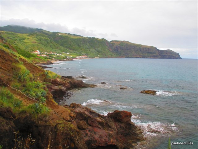
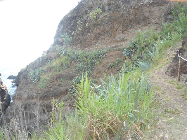
Trilho pedestre Macela-Prainha-Praia Formosa
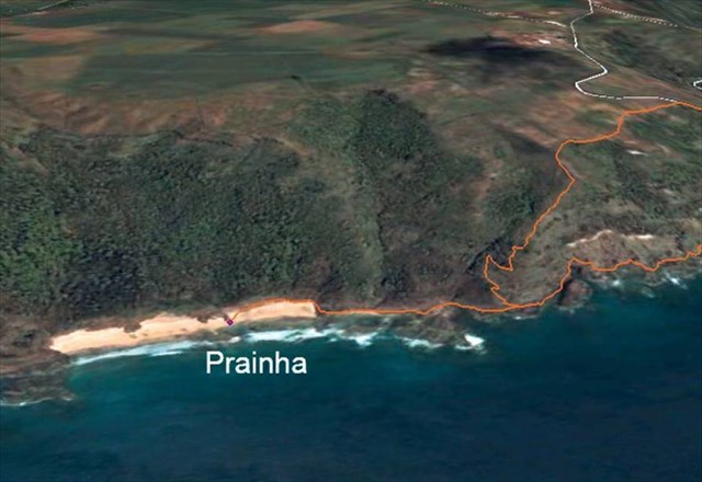
A ilha de Santa Maria possui muitos trilhos pedestres, destacando-se atualmente o grande trilho.
“O GZ desta earthcache encontra-se no trilho “A Rota dos Fósseis”, o caminho pedestre Macela-Prainha-Praia Formosa. Este trilho linear com cerca de 6 km de extensão, com um grau de dificuldade médio e uma altitude que varia entre o nível do mar e os 115 metros, tem início na Macela, prolonga-se até à linha de costa sobranceira à Prainha, aí desce até à zona litoral, continua ao longo de toda a extensão da Prainha (para Oeste) e termina na Praia Formosa, permitindo aos seus visitantes a oportunidade de poderem apreciar, para além da beleza paisagística e da fauna e flora, a riqueza de um vasto conjunto de fósseis existentes ao longo da orla marítima”.
PARA REALIZAR E REGISTAR ESTA EARTHCACHE:
PERGUNTAS:
Para “encontrar/registar” esta cache deverá: provar que esteve no local e responder às seguintes questões, enviando um email/mensagem de Geocaching, com as respostas, em português ou em inglês, para o nosso perfil.
Só depois, de enviar as respostas, e conforme as “guidelines” para as Earthcaches, deverá efetuar o seu registo!
Serão removidos todos os registos que não obedeçam a estes requisitos.
1. Estudando o tema geológico proposto nesta earthcache, responde às seguintes questões geológicas:
a) As lavas mais antigas de Santa Maria têm que idade? Reportam-se a que período geológico?
b) Explica, por palavras tuas, por que razão se sabe que a ilha de Santa Maria esteve com grandes zonas (hoje fora de água) debaixo de água.
c) Diga, por palavras suas, o que são “filões”?
2. A partir das tuas observações realizadas no GZ, responde às seguintes questões:
a) Classifica o “tipo de filões”, presentes no local.
b) Estima o comprimento (desde que é visível e até terminar no mar), largura (onde é mais largo) e altura (a maior visível) do filão existente no GZ.
c) O filão existente no GZ encontra-se completo (inteiro)? Se não indica qual a causa de estar incompleto.
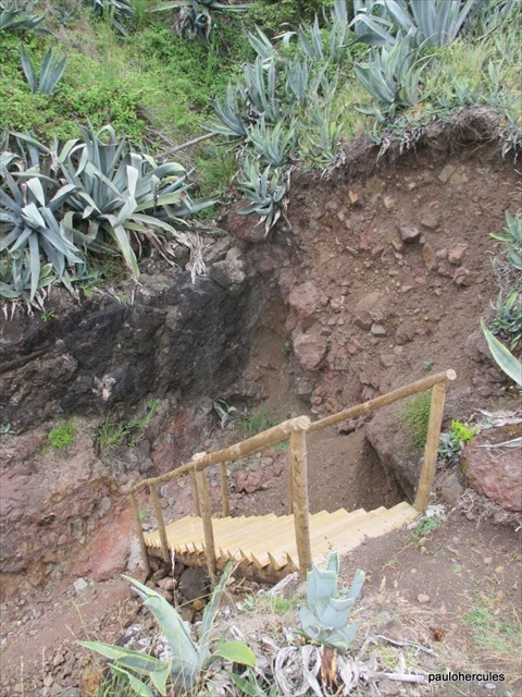
d) Perto do GZ existe uma rocha negra, de forma esférica (foto spoiler).
Nesta rocha é visível um fenómeno geológico importante. Identifica-o.
3.
TAREFA OBRIGATÓRIA:Deverá tirar uma foto sua, onde você apareça (ou com um papel/placa onde conste o seu nickname e a data da visita) e que comprove a sua presença no GZ desta EC - NÃO METASPOILERS. Esta foto deverá ser colocada no seu registo ou enviada por email ou sistema de mensagens de Geocaching, para o owner!

Não responderemos ao seu contato, a não ser que haja algum “problema” com as suas respostas ou registo.


PRAÍNHA DIKES
[Santa Maria – Azores]
ENGLISH

EARTHCACHE

Santa Maria Island
"The island of Santa Maria belongs to the archipelago of the Eastern Group of the Azores, which fa¬zem also part of the island of São Miguel and the islets of Ants; is located between 37º01'16 '' (islet Lagoinhas) and 36º55'37 '' (Ponta da Malbusca) north latitude and 25º11'27 '' (Tip of the Lamb) and 25º00'49 '' (Ponta das Eirinhas ) west longitude.
Santa Maria island is more "old" the Azores, dating older lavas at a higher age of 10 million years.
Contrary to what is commonly said in the islands, Santa Maria is volcanic in nature.However, his advanced age, compared to other islands of the archipelago, determines that the original volcanic forms are already very degraded and are difficult to identify. Due to the strong survey suffered by the island since the late Pliocene, Santa Maria is the only island of the Azores where important lie exposed volcanic and sedimentary rock sequences (fossiliferous) underwater genesis. These allow to reconstruct a complex history of variations on sea level that covers the last 10 to 8 million years (Ma) in the history of the NE Atlantic.
The island emerged in the Miocene (there are about 10-8 Ma), is the oldest of the archipelago. Volcanic activity lasted until the Pliocene (there are about 2 Ma), with phases alternately subaerial and underwater, effusive and explosive. The sedimentary sequences, interspersed in the volcanic series, or overlapping those, dating from the late Miocene (≈5,5 Ma) to the Quaternary (less than 130,000 years?).
The volcanological point of view, points out in Santa Maria, the occurrence of abundant outcrops of pyroclastic rocks and basaltic submarine (pillow lava), particularly along the coast (except for the west coast) from the Figueiral to Chalk. This type of material is not exposed in any other Azorean island because they are covered by lava subaerial latest or below the current sea level.
The existence of evidence of raised beaches to those altitudes means that Mary rose (or uplift is still in process) relative to the current level of the sea. Another fact that testifies to the survey of the island of Santa Maria is the abundant occurrence of pillow lava ("pillow lavas") at various altitudes. As these lavas is always form under water, his observation sometimes more than 100 meters above sea level implies the sharp isostatic lifting of the island of Santa Maria in relation to the seabed on which, since during the last 5 million years the level of the sea have been at most about 50 m above the current ".
(FOTO SPOILER)
DYKES
The dykes are magmatic bodies, in tabular form, resulting from the completion of existing fractures in the rocks. Their attitude and dimensions are variable and may have thicknesses ranging from a few millimeters (filonetes) a few meters or even kilometers and stretches from a few meters to kilometers. Its thickness is not always constant and sometimes it branches. Are observed frequently textural and mineralogical variations in the same dyke.
DYKES OF QUARTZ
In fractures can circulate hot water solutions (hydrothermal fluids), magmatic or other source, enabling the precipitation of minerals which thus constitute the so-called hydrothermal dykes. These are, in general, considerably longer than thick (typically 100 to 1000 times). The circulation of fluids enriched in silica allows the formation of dykes and quartz “filonetes”, particularly on granite Geres. They are sometimes fails to fill zones. The movement along the fault causes crush siliceous material, giving it thus a gap looks like. When quartz is associated, sometimes, iron oxides or sulfides disseminated.
Dykes and pegmatites masses, aplites and aplite-pegmatite
Dykes and masses of aplites and pegmatites represent the most hydrated portion and later crystallization of magma. In the later stages of the crystallization magmatic melts are enriched in residual volatiles such as water, fluorine and boron. They may further contain other chemical elements that do not enter into the structure of the minerals already formed and therefore focused this residual magma, such as Be and Sn, among many others. As a result, from the residual magma may crystallize rare minerals as they are essential constituent elements such as beryllium (beryllium aluminum silicate), cassiterite (tin oxide), topaz (aluminum silicate and fluoride) and tourmaline ( silicate complex with boron, iron and sodium). The pegmatites and aplites have very different compositions, but most have granitic composition, with quartz, K-feldspar and albite, then assigning of granitic pegmatites. In the same vein can coexist aplítico fill and pegmatite, as Pegmatitic portion in the central zone and a peripheral zone in aplítica or vice versa.
BASIC ROCKS DYKES
|
Basic composition of magmas also meet often fractures in granitic rocks, causing veins with a dark color that is due to the abundance of minerals iron and magnesium oxides (such as pyroxene, amphibole, biotite, etc ...). Its texture is clearly thinner than the plutonic igneous rocks such as granites. This is due to the fact that its crystallization, though taking place in depth, is faster than in granites. In fact, magmas basic in nature, upon cooling, initiate crystallization at higher temperatures than the granite magmas, and furthermore, if instruct fractures of the upper crust tend to cool more quickly due to the thermal contrast with the rocks encaixantes. Due to its composition rich in minerals iron and magnesium oxides, these rocks are weathered easily because such minerals are more susceptible to change than quartz and potassium feldspar. It will, therefore, to provide a seam basic rock introduce more changes than the surrounding granite rock. This transformation is clearly visible in the basic rock veins that occur in the area of Gerês Park, the Portuguese mainland, intensely changed to a clay mass brown.
|
|
|
“Macela-Prainha-Praia Formosa” - Rail pedestrian
The island of Santa Maria has many hiking trails, currently standing out the big rail.
"The GZ this EarthCache is on track" The Fossils Trail ", the way pe¬destre Macela-Prainha-Praia Formosa. This linear rail with about 6 km from ex¬tensão, with an average degree of difficulty and an altitude ranging between sea level and 115 meters, starts from the Macela, extends to the shoreline overlooking the Prainha , then descends to the coastal zone, continues along the entire length of Prainha (to the west) and ends at Praia Formosa, allowing visitors the opportunity to appraise, in addition to beautiful landscapes and fauna and flora, wealth a wide range of existing fossil along the seafront. "
TO PERFORM AND LOG THIS EarthCache:
QUESTIONS:
To "find / register" this cache must: prove that visited the site and answer the following questions by sending an email / message Geocaching, with answers (in Portuguese or in English, only) to our profile.
Only later, sending the answers, and as the "guidelines" for EarthCaches should make your registration! They will be removed from all records that do not meet these requirements.
1. Studying the geological theme proposed this EarthCache, answer the following geological questions:
a) The oldest lavas of Santa Maria have to age? Report to that
geological period?
b) Explain, in your words, why it is known that the island of Santa
Maria has been with large areas (now out of the water)
under water.
c) Say, for his words, which are "veins"?
2. From your observations in GZ, answer the following questions:
a) Sorts the "type of veins" on site.
b) the estimated length (since it is visible and finish up at sea), width
(which is wider) and height (most visible) the existing seam in GZ.
c) the existing seam in GZ is complete (whole)? It does not indicate
the cause of being incomplete.
d) Near the GZ there is a black rock, spherical (photo spoiler).
This rock is visible an important geological phenomenon.
Identifies it.
3.
TASK (not optional): You must take a picture of yourself, where do you show up, (or with a paper / plaque with your geocaching nickname and the date of the visit) and that proves your presence in the GZ of this EC - no spoilers please. This photo must be placed in your log or sent by email or Geocaching messaging system, to the owner!

We do not respond to your touch, unless there is a "problem" with their answers or register.