English:
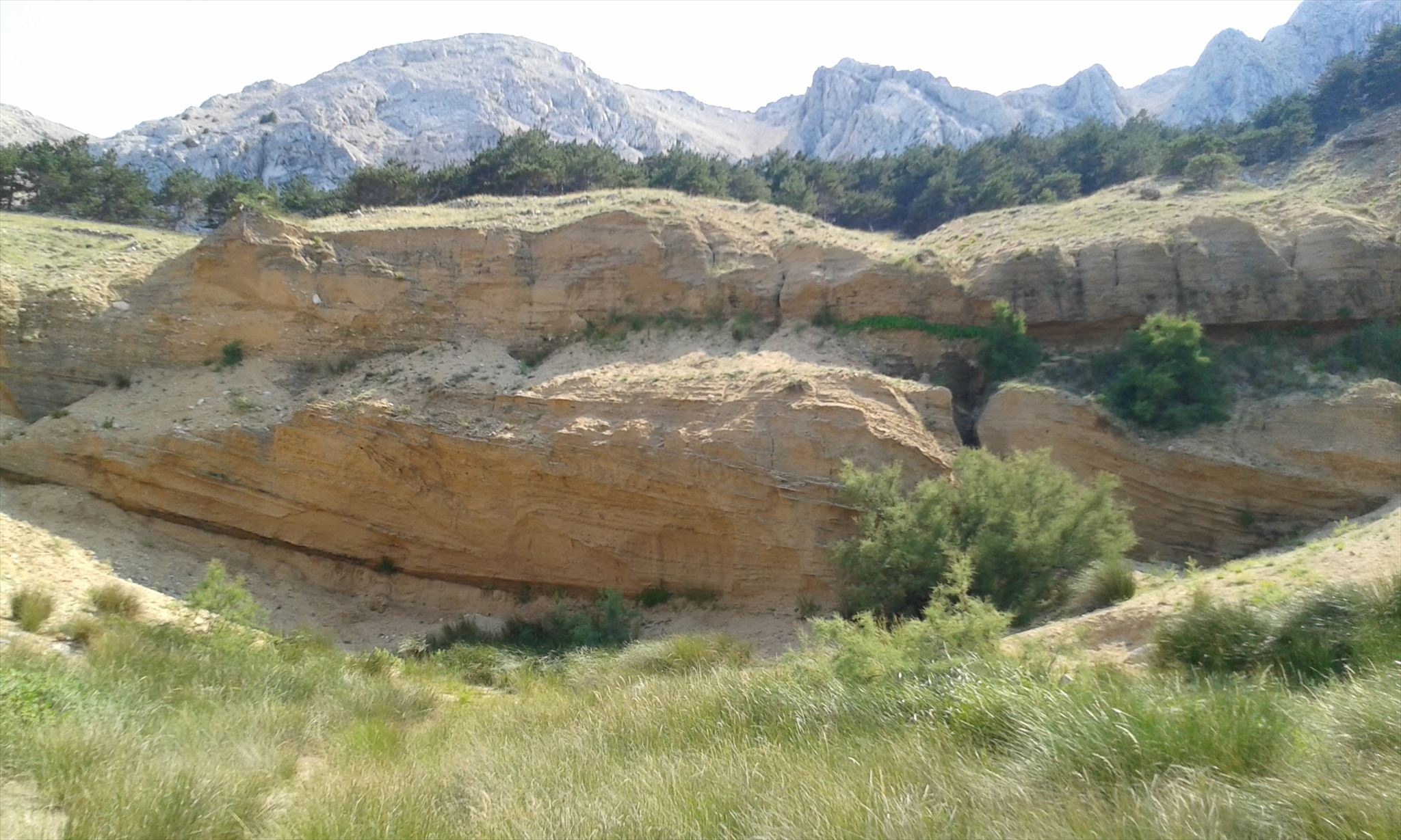
At the western side of Baṥka Bay lies the Zarok sandy area. A sand and rock massif that shows impressive the geological development of the area and whole island of Krk as it is today. The tourism boom and the insatiable need for the exploration of sand for buildings have also taken their toll on this extraordinary natural landscape. These interventions have destroyed the central part of the sand and gravel layers – which in the past were home to very interesting rare and endemic plants.
What could be seen at the massif:
The sick layers of sand and gravel hide valuable information about the past millennia – the times when the climate in the Baṥka Valley was quite different and charactered by glaciation. This was the Pleistonce epoch, charactered by the changing of cold and warm periods – glacial and interglacial periods. The movement of glaciers, as well as streams and rivers, that were formed by retreating glaciers, resulted in the sedimentation of layers of limestone breccia, sand, gravel and clay, which alternate with the layers of paleosols (fossil soil), which are usually of a dark colour as they were formed in warmer periods.
To log this Earth Cache please answer the following question and send me the answer via my profile. After sending the answers you can log immediately. If something is not correct, I will contact you.
Go to N44 57. 501 E014 44.747. Sure you can step closer if you want.
Please describe in your own words the forms and the colours of the layers. Do you recognize something special?
Optional: It would be great if you would put a photo of you or your GPS at your log.
Happy hunting!
Please pay attention: The Earth Cache lies at an official trail and is free accessible. To make sure that the nature is not damaged please do not leave the trail.
Further informations at the County of Primorje-Gorski Kotar www.pgz.hr
Primorje-Gorski Kotar County, Adamićeva 10, Rijeka, Phone +385 51 351 600
Deutsch:
Am westlichen Rand von Baṥka liegt die „Zarok sandy area“. Ein Sand- und Felsmassiv, welches die geologische Entstehung dieser Region der Insel Krk widerspiegelt. Durch den schnell wachsenden Tourismus der zurückliegenden Jahre wurde leider viel der Formation zerstört. Zum Gewinn von Baumaterial und zur Vergrößerung des Badestrandes wurden diese einzigartigen Zeugnisse der Region zu einem großen Teil zerstört. Damit wurden ebenfalls seltene Pflanzen nahezu verdrängt, welche die Felsformation als Lebensraum benötigen.
Die dicken schichten von Sand und Kies enthalten geologische Informationen über vergangene Zeiten, als das Klima in der Bucht von Baṥka stark unterschiedlich war und durch Gletscherbildung sowie Gletscherschmelze charakterisiert war. Dies war die Pleistzäne Epoche. Charakteristisch für diese Zeit war der Wechsel von kalten und warmen Perioden – Gletscherbildung sowie Gletscherschmelze. Gletscherbewegungen sowie Flüsse und Ströme, die durch Schmelze entstanden waren, sorgten für die Entstehung von Ablagerungsschichten von Kalkstein, Sand, Kies und Ton, die sich durch das wechselnde Klima abwechselnd ablagerten. Durch die Entstehung in deutlich wärmeren Klima stellen sie sich in ungewöhnlich dunkler Farbe dar.
In den zu findenden Ablagerungsschichten sind die verschiedenen Ablagerungsschichten gut zu erkennen. Die geologischen Eigenschaften dieses Untergrunds sind Lebensraum für seltene Pflanzen und Tiere, die vom aussterben bedroht sind.
Um diesen Earth Cache zu loggen begebt euch zu folgender Koordinate N44 57. 501 E014 44.747. Natürlich könnt Ihr näher herantreten wenn Ihr möchtet. Beschreibt in euren eigenen Worten die Gestalt der Ablagerungsschichten in Form und Farbe. Fällt Euch etwas Besonderes auf?
Optional: Es wäre schön, wenn ihr ein Foto von Euch oder eurem GPS an euren Log anhängen würdet.
Schickt mir eure Antwort über mein Profil, danach könnt ihr sofort loggen. Sollte etwas nicht stimmen, werde ich mich melden.
Happy hunting!
Achtung: Der Earth Cache liegt an einem offiziellem Wanderweg und ist direkt vom Weg frei zugänglich. Um die Natur zu schützen verlasst bitte nicht den Weg. Danke!
Für weitere Informationen: County of Primorje-Gorski Kotar www.pgz.hr
Primorje-Gorski Kotar County, Adamićeva 10, Rijeka, Phone +385 51 351 600