Note: This is an Earthcache. There is no physical cache to find. Logging this Earthcache requires that you undertake an educational task relating to the specific Earth Science at the site.
Prior to logging this cache, click on Message this owner, or send an email with answers to the following questions:
- How was this impact crater discovered?
- What would you expect to see as evidence of the crater?
- What do you see as evidence of the crater?
- Required to log this cache: Please provide a photo of yourself or a personal item in the picture to prove you visited the site. Upload the photo with your log.
Chesapeake Bay Impact Crater
The world’s sixth largest impact crater was created about 35 million years ago when a two to three mile wide asteroid or comet splashed into a shallow sea and shattered the Earth’s crust. It is one of the best preserved marine impact craters, and the largest known impact crater in the U.S.
The entire circular crater is about 53 miles in diameter and almost a mile deep. This is an area twice the size of Rhode Island, and nearly as deep as the Grand Canyon.
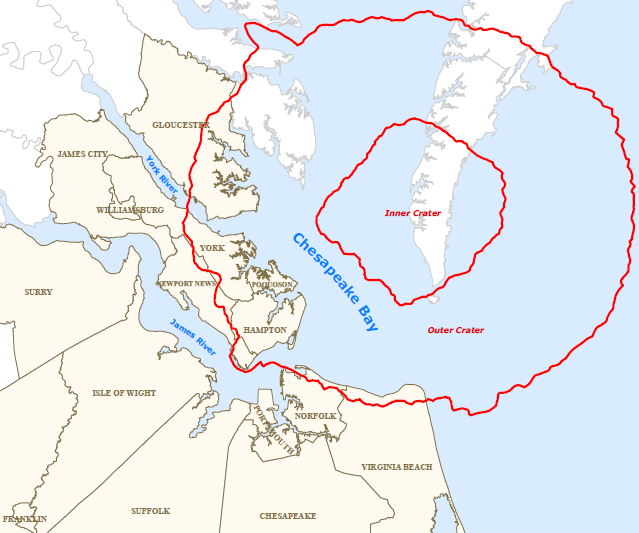
Debris shot up and everything within 600 miles was killed. Debris from the impact has been identified as far away as the Caribbean Sea. The crater was eventually discovered because of this debris. Until 1983, no one suspected the existence of the large impact crater buried beneath the lower part of the Chesapeake Bay and its surrounding peninsulas. The first hint was an 8 inch thick layer of ejected material that turned up in a drilling core taken off Atlantic City, NJ. The layer contained fused glass beads called tektites and shocked quartz grains that are unmistakable signs of the impact. In 1993, data from oil exploration revealed the extent of the crater.
The York River bends sharply to the northeast because it crosses the underlying crater rim. Continued slumping of sediments over the rubble of the crater has helped shape the Chesapeake Bay. The impact also disrupted aquifers making the entire lower Chesapeake Bay area more susceptible to groundwater contamination.