De nombreux îlots ou écueils de dimensions très variables ponctuent toute la côte de Penmarch : les plus importants sont les Étocs au sud de Kérity et l'île Saint-Nonna à l'ouest de Saint-Pierre ...
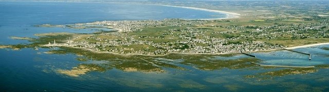
Du côté du port de Saint-Guénolé, qui présente une passe ouverte plein ouest réputée dangereuse par gros temps, se trouvent deux presqu'îles granitiques : Conq au nord-ouest et Krugen au sud.
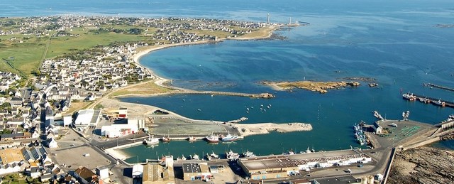
Krugen à la particularité d'être reliée à la côte par un isthme sableux, que cette earthcache vous invite à découvrir.
Un isthme est un territoire très étroit qui réunit deux grandes étendues de terre. Le plus connu (et certainement le plus grand) est l'isthme de Panama.
Intéressons nous à la formation de cette particularité géologique qui se forme par accumulation des débris rocheux (cailloux, sables ou encore boues), arrachés par la mer aux côtes environnantes. Si les courants faiblissent, la mer dépose les débris et l’isthme se constitue.
D'un point de vue géologique
A Penmarc’h, la côte bretonne bifurque brusquement à l’Est et c’est à Saint-Pierre, au phare d’Eckmühl, que commence le Golfe de Gasconne. La côte basse constitue la partie émergée d’une ancienne plate-forme d’abrasion marine. Nulle part ailleurs en Bretagne on ne trouve d’aussi basses surfaces rocheuses en bordure de mer. La plate-forme pleistocène n’est pas horizontale, elle s’élève légèrement vers Saint-Guénolé où elle est la plus haute.
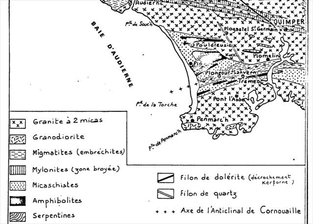
Le changement d’orientation de la côte, sa très faible élévation, son tracé, sont en rapport direct avec la tectonique tertiaire, avec les déformations de la surface éocène.
De toutes les pointes de la péninsule bretonne, la pointe de Penmac’h est la plus exposée à l’érosion. Son orientation face aux vents les plus violents n’est tempérée par aucun barrage. La plate-forme d’abrasion à une largeur de 3,5 km de Saint-Guénolé à Lescors.
Érosion sous l’effet de la force éolienne
Les vents d’Ouest sont prépondérants sur cette partie de la côte. Mais en 40 ans un changement de 70° est advenu dans la direction générale des vents allant du Nord-Ouest dans la période 1949 - 1961 à l’Ouest-Sud-Ouest dans les années 1985 - 1990. En modifiant sa direction, le vent modifie également l’angle d’incidence d’arrivée de la houle sur la côte. Le recul du littoral s’effectue aussi par à-coups, sous l’action des tempêtes.
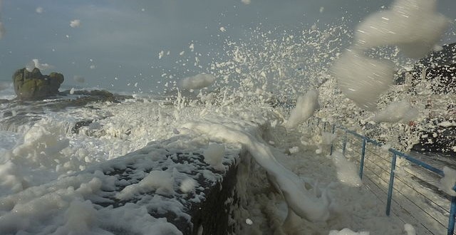
Mais aussi sous l’effet des forces marines
Les actions de la houle et des courants de marées sont responsables des variations sédimentologiques de cette partie de la côte. Le site de la Joie présente, malgré la présence d’un plateau rocheux qui tendrait à freiner les houles, 3 secteurs sensibles à l’érosion marine :
-
à Saint-Guénolé au Sud de Krugen
-
à l’endroit d’un étroit chenal sur le flanc de la chapelle de la Joie
-
à Saint-Pierre, au Nord-Ouest du phare d’Eckmühl
Sans compter sur l’action de l’homme
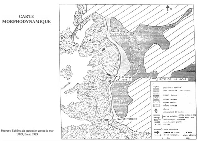
Le schéma de protection contre la mer, élaboré en 1983 par l’U.B.O relate que l’évolution morphologique du cordon dunaire entre La chapelle de la Joie et Saint-Guénolé a été bloqué par des ouvrages en maçonneries.
Ainsi la protection du port de Saint-Guénolé a nécessité la construction de plusieurs ouvrages visant à freiner l’érosion frontale et les risques d’inondations marines. Avec de 1952 à 1954 la réalisation d’un mur barrage de 400 m de long et en 1962 un ouvrage de 250 m sur l’île Conq.
L’érosion frontale des estrans meubles ne s’est pas arrêté pour autant et une dérive d’orientation Sud-Nord entraîne les sédiments vers le port de Saint-Guénolé à l’entrée duquel ils s’accumulent.
Pour valider cette earthcache
Rendez-vous aux coordonnées de cette earthcache, (N 47° 48.766 W 004° 22.707) là vous pouvez observer les sédiments présents à vos pieds. Comment pouvez-vous qualifier ce type de sédiments ? Sable, graviers ou rochers ?
Au second waypoint (N 47° 48.782 W 004° 22.579 ) vous pouvez observer les sédiments présents à vos pieds. Comment pouvez-vous qualifier ce type de sédiments ? Sable, graviers ou rochers ?
Enfin avec les éléments d'informations présents sur cette page et vos observations sur le terrain pouvez-vous citer 2 éléments qui expliquent la formation de cet isthme ?
Vous pouvez loguer votre découverte mais vous devez m'envoyer vos réponses par email (via mon profil) ou via la messagerie interne. Sans réponses de votre part votre log sera supprimé.
Vous pouvez aussi vous prendre en photo aux coordonnées de cette earthcache (avec l'île de Krugen dans votre dos) pour illustrer votre découverte, mais cela n'est pas obligatoire !
English version
Many islands or very variable dimensions pitfalls punctuate the coast of Penmarch: the most important are the Etocs south of Kérity and St. Nonna island west of St. Peter ...
Near the port of Saint-Guénolé, which has an open pass due west to be dangerous in bad weather, there are two granite peninsulas: Conq northwest and south Krugen.
Krugen the distinction of being connected to the coast by a sandy isthmus that earthcache invites you to discover.
An isthmus is a narrow territory that brings together two large tracts of land. The best known (and certainly the largest) is the Isthmus of Panama.
We are interested in the formation of this geological feature that is formed by the accumulation of rock debris (pebbles, sand or sludge), torn by the sea to the surrounding coasts. If the currents weaken, sea deposits the debris and the isthmus was formed.
A geological point of view
A Penmarc'h, suddenly branches off the Brittany coast in the East and is in Saint-Pierre, the Eckmühl lighthouse, begins the Gulf of Gascony. The chuck is the tip of an old marine abrasion platform. Nowhere else in Britain we find such low rock surfaces by the sea. The Pleistocene platform is not level, it rises slightly towards Saint Guénolé where it is the highest.
The shift from the coast, its low elevation, its route, are directly related to the Tertiary tectonics, with the deformation of the Eocene surface.
Of all the tips of the Breton peninsula, advanced Penmac'h is the most exposed to erosion. Its orientation facing the strongest winds are tempered by dams. The platform abrasion to a width of 3.5 km from Saint-Guénolé to Lescors.
Erosion under the impact of wind power
The westerly winds are dominating this part of the coast. But in 40 years, a change of 70 ° happened in the general direction of the winds from the Northwest in the period from 1949 to 1961 in the West-Southwest in the years 1985 - 1990. In changing its direction, wind also changes the incidence angle of arrival of the waves at the coast. The coastal retreat also takes place in spurts, under the action of storms.
But also as a result of navies
The shares of the wave and tidal currents are responsible sedimentological variations of this part of the coast. The Joy this site, despite the presence of a rocky plateau that would tend to slow swells, 3 areas susceptible to sea erosion:
-
Saint-Guénolé south of Krugen
-
at the location of a narrow channel on the side of the chapel of Joy
-
Saint-Pierre, in the northwest of the lighthouse Eckmühl
Without relying on human action
The scheme of protection against the sea, developed in 1983 by UBO reports that the morphological evolution of the dune belt between Chapel of Joy and St. Guénolé was blocked by the works in masonry.
The protection of the port of Saint-Guénolé required the construction of several works to curb the frontal erosion and the risk of marine flooding. With 1952 to 1954 the realization of a dam wall 400 meters long and in 1962 a book of 250 m on the island Conq.
The front furniture foreshore erosion has not stopped, however, and a south-north orientation drift causes sediment to the port of Saint-Guénolé to whose input they accumulate.
To validate this earthcache
Go to the coordinates of this earthcache (N 47° 48.766 W 004° 22.707) where you can observe the sediments at your feet. How can you call this type of sediment? Sand, gravel or rocks?
In the second waypoint (N 47° 48.782 W 004° 22.579 ) you can observe the sediments at your feet. How can you call this type of sediment? Sand, gravel or rocks?
Finally with the items of information found on this page and your field observations can you name two elements that explain the formation of the isthmus?
You can log your discovery but you must send me your answers by email (via my profile) or via the internal messaging system. No answers from you your log will be deleted..
You can also take pictures of the coordinates of this earthcache (with island Krugen in your back) to illustrate your discovery, but it is not mandatory!
Sources
Penmarc'h sur wikipedia
Commune de Penmac’h, plan de présentation des risques naturels prévisibles