The Point at Harpers Ferry EarthCache
The Point at Harpers Ferry
-
Difficulty:
-

-
Terrain:
-
Size:  (other)
Please note Use of geocaching.com services is subject to the terms and conditions
in our disclaimer.
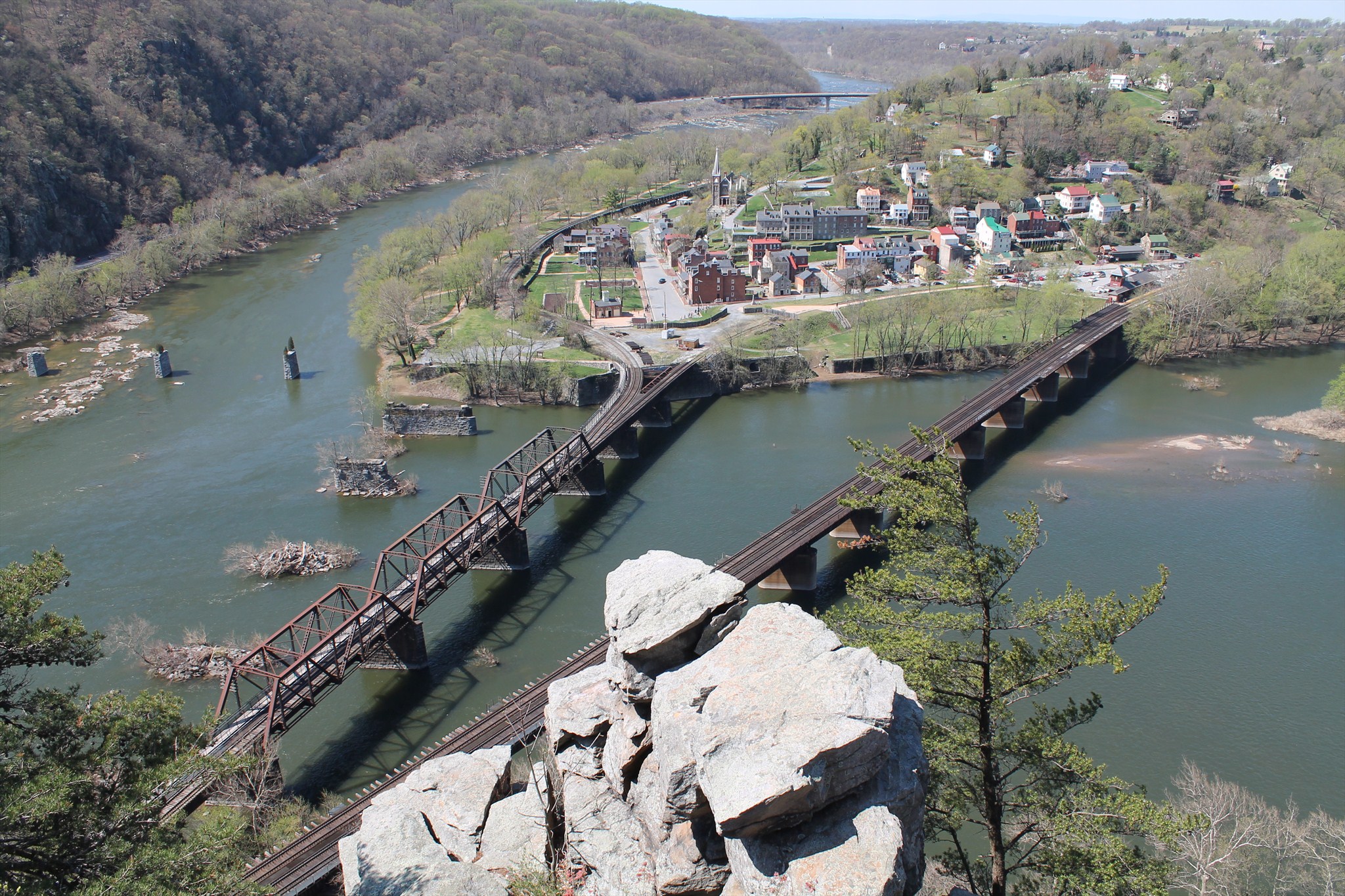
A confluence, also known as a conflux, is the meeting of two or more bodies of water. The term refers either to the point where a tributary joins a larger river, called the main stem, or where two streams meet to become the source of a river of a new name. In the case of The Point at Harpers Ferry, the Potomac River's main tributary, the Shenandoah, comes to an end at the confluence. The Potomac River, meanwhile, continues its journey from the mountains of West Virginia past Washington, D.C., and eventually into the Chesapeake Bay.
Thank you to Harpers Ferry National Historical Park for granting permission for this Earthcache.
Photo above taken from the nearby Maryland Heights (part II) virtual cache on April 13, 2013.
HISTORY OF 'THE POINT'
When the Wager family, heirs to Robert Harper, sold land to the government for the United States Armory and Arsenal at Harpers Ferry in 1796, one of the two parcels of land they retained was the "Ferry Lot Reservation". (The other tract was the "Six-Acre Reservation" which comprised the heart of the Lower Town Harpers Ferry). The 3/4-acre "Ferry Lot Reservation" sat at the confluence of the Potomac and Shenandoah rivers, and became a bustling commercial area as the town of Harpers Ferry grew.
A major contributor to the prosperity of the "Ferry Lot Reservation" was the completion in 1836 of the B&O Railroad viaduct across the Potomac River. By 1859, structures at The Point included The Gault House Saloon, the Wager House Hotel, the Potomac Restaurant, and several other small shops and businesses. The B&O Railroad and Winchester & Potomac Railroad also maintained passenger depots here. But the prosperity of the "Ferry Lot" ended with the Civil War.
On June 14, 1861, Confederate troops blew up the B&O Railroad bridge. Eight months later, on February 7, 1862, Union troops burned all the buildings on The Point to prevent Confederate sharpshooters from using them for cover. During the course of the Civil War, the railroad bridge was destroyed and replaced nine times.
After 1862, the B&O Railroad began erecting new iron spans designed by Wendell Bollman. By 1870, this "Bollman Bridge" was completed. Bollman’s iron spans carried the B&O mainline until 1894, and continued to serve as a highway bridge into the 20th century.
Floodwaters in 1924 swept away three iron spans, but these were promptly replaced. Twelve years later the record Flood of 1936 destroyed this bridge for good.
Today, the former "Ferry Lot Reservation," now known simply as "The Point," is a popular spot for tourists to gather and take photos of the rivers' confluence and other beautiful scenic views of the area.
FLOODING OF HARPERS FERRY
Floods have inundated the Lower Town since the first white settlers arrived here more than two centuries ago. The town's more memorable floods are listed below.
1748. According to local legend, floodwaters drove Robert Harper from the log cabin he had acquired from Peter Stephens.
1753. "The Pumpkin Flood," so named for the great numbers of pumpkins washed down from the gardens of nearby Indian villages.
1852. The greatest flood since the first settlers arrived at Harpers Ferry. Waterpower dams on the Potomac and Shenandoah rivers suffered considerable damage.
1870. (September 30-October 1). The Shenandoah River rose so rapidly that residents were trapped on Virginius Island. Floodwaters swept away much of the island's homes and industry and claimed 42 lives at Harpers Ferry.
1877. (November 25). High water caused considerable damage to the C&O Canal and closed the old Shenandoah Canal for good. The flood crest was 29.2 feet.
1889. (June 1). The rivers rose to a record height – 34.8 feet – destroying the Shenandoah wagon bridge and forcing the Child & McCreight flour mill on Virginius Island to close for good.
1896. (October 1). One of the worst floods in the town's history. The rivers crested at 33.0 feet.
1924. (May 3). Floodwaters swept away three spans from the Bollman highway bridge across the Potomac River and permanently closed the C&O Canal. The rivers rose to 27.6 feet.
1936. (March 18-19). 36½ feet – the all-time record crest at Harpers Ferry. The Bollman highway bridge and Shenandoah bridge were swept away for good, while many businesses in the Lower Town were left in ruins.
1942. (October 16). All-time record crest for the Shenandoah Valley. Floodwaters reached 33.8 feet in Lower Town Harpers Ferry.
1972. (June 23). Floodwater from Hurricane Agnes swelled to 29.7 feet here but caused relatively little damage.
1985. (November 5-6). The Potomac and Shenandoah rivers crested at 29.8 feet in Lower Town Harpers Ferry, leaving behind several inches of mud.
1996. January 20-21: Rain and snowmelt from the record Blizzard of January 1996 – which dumped more than two feet of snow in the valleys of the Potomac and Shenandoah – caused the rivers to rise to 29.4 feet in Lower Town Harpers Ferry. September 8: Devastating rains from the remnants of Hurricane Fran fell across the Shenandoah and Potomac river basins. The rivers rose to 29.8 feet, marking the first time in the town's history that two floods in excess of 29 feet have occurred in a single year.
FACTORS THAT AFFECT FLOODING
The size and shape of a river’s drainage basin dictates how much precipitation the river can receive and how quickly it will arrive (the lag time). A large drainage basin means that the river’s catchment area is large so it will collect a lot of water, increasing discharge. If the basin is circular in shape, the precipitation will enter the river at roughly the same time because all points in the basin are equidistant from one another. This will produce a high peak discharge and can lead to flash floods.
The permeability of the soil and rock in a drainage basin is a big factor in flooding. If the basin’s soil is impermeable, maybe because it has been saturated by previous rainfall or has been baked by prolonged heating, then any precipitation that falls won’t infiltrate and will instead run straight into the river, increasing the river’s discharge and triggering floods. Similarly, if the rocks in the area are non-porous or impermeable (such as granite or clay) then water won’t be able to infiltrate into the rocks and will, again, run straight off into the river increasing its discharge.
The vegetation cover in a basin will affect flooding. If a basin has very dense vegetation cover, the vegetation will intercept precipitation and store it, reducing the volume of water entering a river. Conversely, if a basin is sparsely vegetated then there will be no interception and so more water will enter a river. Vegetation helps bind soil too. With no vegetation, the soil is highly susceptible to mass wasting which can cause large volumes of soil to enter a river and reduce the river’s capacity.
The relief and steepness of the basin affects how quickly water enters a river and so how likely a river is to flood. If the river’s valley has steep sides, water will quickly enter a river increasing the river’s discharge.
The number of tributaries flowing into a river affects the likelihood of floods. If a river has a lot of tributaries, the river’s discharge will be much higher because lots of water will be entering it from its tributaries. After heavy precipitation, the discharge will rise even more and floods are likely, especially at confluences (where a tributary meets the river) as this is where discharge is highest.
Information above via these sites:
HISTORY
HISTORIC FLOODS
FACTORS THAT AFFECT FLOODING

EARTHCACHE REQUIREMENTS
To earn credit for this earthcache, please visit the location and send a message with the answers to the following questions:
1.) Using what you've learned, and considering the sources and eventual end points of the Potomac and Shenandoah rivers, which river do you think floods more often, and why?
2.) At the nearby base of the bridge over the Potomac River is a flood gauge. (WAYPOINT 2)
What is its reading during your visit? Is this below or above flood stage?
3.) On an outside wall of the hardware store nearby is a marker showing the levels of historic floods, putting all these numbers into perspective. (WAYPOINT 3)
Using what you've learned and examining the nearby Shenandoah River, what steps (if any) do you think Harpers Ferry could take to avoid the potential for another large flood like those commemorated here?
4.) THIS IS OPTIONAL: Take a photo standing at The Point, holding your GPS. Feel free to upload it along with your log.
NOTES ABOUT PARKING WAYPOINTS
Parking in Lower Town can often be scarce. I've provided three options for parking in the attempt of helping you better enjoy your visit.
PARKING WAYPOINT A: Your best bet is to park at the Visitor Center off US 340; however, a $10/vehicle admission fee applies (with the exception of designated free days). From the Visitor Center, you can take a shuttle bus to Lower Town or you can hike/bike the Lower Town Trail. It's about 2 miles to The Point from here on the trail. If you hike in and want to take the shuttle bus back, you can hop on at the Lower Town bus stop (waypoint also provided).
PARKING WAYPOINT B: A small, free parking lot is available near the intersection of US 340 and Shenandoah Street, about 8/10 mile from The Point. This lot fills up fast, especially on weekends and holidays.
PARKING WAYPOINT C: If you are visiting on a weekday, during the offseason or just feel very lucky, you can try to grab one of the few parking spaces downtown near the train station. There are also a very small handful of spots available on the street in this area. If you find a spot here without much trouble, consider yourself blessed.
Additional Hints
(No hints available.)