|
|
|
|
|
|
Teci Dravo, Savo teci,
Nit' ti Dunav silu gubi,
Sinje more svijetu reci:
Da svoj narod Hrvat ljubi! |
|
Drava, Sava, keep on flowing,
Danube, do not lose your vigour,
Deep blue sea, tell the world,
That a Croat loves his homeland. |
|
| Lijepa naša domovino ("Our Beautiful Homeland", national anthem of Croatia), lyrics by Antun Mihanović (1835) |
|
|
|
|
|
|
|
 |
|
 |
|
|
|
Facts about Drava
|
|
| Name |
|
Drava (HR, IT, SL), Drau or Drave (DE), Dráva (HU) |
|
| Length |
|
ca. 720km (depending on measuring between 707km and 749km) |
|
| Source |
|
Toblach, South Tyrol, Italy (elevation: 1.450m) |
|
| Mouth |
|
Aljmas, Croatia, into Danube (elevation: 90m) |
|
| Countries |
|
Italy, Austria, Slovenia, Hungary, Croatia |
|
| Tributary rivers |
|
11 (left: Isel, Möll, Lieser, Gurk, Lavant, Mur; right: Gail, Vellach, Mieß, Dravinja, Bednja) |
|
| Discharge at mouth (average) |
|
670 m3/s |
|
|
|
Nepromijenjeni donji tok Drave
Vece europske rijeke imaju vazan ekonomski faktor. Rijeke se koriste za transport, hidroelektrane proizvode struju, tvornice koriste vodu za svoje rashladne sisteme, otpadne vode ispustaju se u rijeke dok se ta ista voda iz rijeka iskoristava za pice. Rijecni inzenjering ima kljucnu ulogu u povecavanju dobrobiti koje rijeke mogu donijeti biznisu. Ukratko, rijecni inzenjering poznaje dvije metode: poboljsati tok rijeke i usporiti tok rijeke.
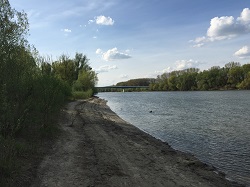
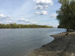
Samo dvije rijeke u Europi su jos uvijek u svom prirodnom,nepromijenjenom koritu: Lora u Francuskoj i donji tok Drave izmedu Slovenije, Madarske i Hrvatske.
Posjecujuci koordinate ovog EarthCache-a, imat cete priliku saznati zanimljive cinjenice o jedinstvenom koritu donjeg toka rijeke Drave. |
|
|
|
Unadulterated lower Drava
Europe's bigger rivers hold an important economic factor. A river is used for transportation, hydroelectric power stations are producing electricity, factories are using the water for their cooling systems, and wastewater is leaded into the river, just as drinking water is taken out of the river. River engineering is the key for maximizing the benefit a river can bring for business. In short, river engineering knows two methods: improve the flow of the river and holding back the flow.
Only two rivers in Europe are left in their natural, unadulterated riverbed: The Loire in France and the lower Drava between Slovenia, Hungary and Croatia.
Visiting the coordinates of this EarthCache you’ll have the chance to find out interesting facts about the unique riverbed of lower Drava. |
|
|
|
|
|
Kako se oblikuje rijecno korito
Voda slijedi gravitaciju. Voda koja ne moze daleko teci ce presusiti. Snaga koju tekuca voda ima zove se "competence" i ona se povecava s kolicinom vode te prema gradijentu. Ona moze erodirati odredene materijale iz rijecnog korita i rijecne obale. Dok se teret skupljenog taloga prenosi vodom, zapravo se dijelovi rijecnog korita prenose samim rijecnim koritom. Ako se („competence“) smanji, talog rijecnog korita ce se akumulirati na novim lokacijama. |
|
|
|
How a riverbed is formed
Water follows gravity. Water that cannot seep away will drain off. The force that floating water has is called "competence" and rises with the amount of water and the gradient. It can erode particulate material from the streambed and the riverbank. While suspended sediment load is carried in the water, bed load is carried over the riverbed. If the competence decreases, sediment and bed load will accumulate on new locations. |
|
|
|
|
|
Kako se razvija tok rijeke
Prema gradijentu, eroziji i nakupljanju taloga razvija se tok rijeke:
1. Ravno: Strmi gradijent uzrokuje visoku "competence". Talog se nece nakupljati. Rijecno korito ce biti ravno.
2. Razgranato: Ako je gradijent manji (obicno 4%-2%) rijecni talog (kamen,sljunak,…) ce se nakupiti u male otoke u rijeci, oblici takvih otoka obicno su rombovi. Tijekom susnih razdoblja, ti otoci ce se osusiti i rijeka ce ih obilaziti granajuci se.
3. Vijugavo: Gradijent manji od 2% ne moze uzrokovati eroziju rijecnog korita, ali nakupljeni talog moze erodirati, uglavnom vijugavo. Tijekom duljeg razdoblja dva zavoja se mogu pribliziti jedan drugome dok na kraju brana izmedu njih ne pukne. Voda tada tece kroz novo korito od starog nastane jezero rijecne okuke.
Uglavnom se kombiniraju ova tri tipa. |
|
|
|
How the course of the river is evolved
According to the gradient, erosion and accumulation of load are evolving the course of the river:
1. Straight: A steep gradient causes a high competence. Load will not accumulate. The riverbed will be straight.
2. Branched: If the gradient is less (usually 4% to 2%) bed load (stone, gravel and grid) will accumulate to small islands in the river, usually the shape of those islands is rhombical. During low water periods, those islands will fall dry and the river will go around them in small streams.
3. Meander: A gradient less than 2% is not able to perform an erosion of bed load, but suspended sediment load can erode, mostly at meanders (curves). Over a long period two meander can move towards each other and finally the bank between them can break. Water then floats through the new riverbed and the old stays as oxbow lake.
Mostly those three ideal types are combined. |
|
|
|
|
|
Otkrij geologa u sebi
Kada procitas tekst iznad i kada si na mjestu, nece biti tesko pronaci odgovore na ova pitanja:
1. U blizini ces pronaci dva primjera „kako se razvija tok rijeke“. Imenuj ih i povezi s jednom od tri tocke u tom odlomku.
2. Odgovarajuci na prvo pitanje moci ces procijeniti gradijent rijeke Drave na tom podrucju. Kakav ocekujes da je?
Na pitanja slobodno odgovori na hrvatskom, engleskom ili njemackom jeziku. |
|
|
|
Discover the geologist within you
When you read the text above and you are in place it will not be hard to find out the answers to these questions:
1. Nearby you will find two examples according to "How the course of the river is evolved". Name them and relate them to one of the three points in that paragraph.
2. Answering question no. 1, you should be able to estimate the gradient of river Drava in this area. What do you expect it to be?
Feel free to answer those questions in Croatian, English or German. |
|
|
|
|
|
Kako se ulogirati u ovaj cache?
EarthCache nema materijalni unos; ne moras naci nista osim odgovora na gore postavljena pitanja. Posalji odgovore koristeci „Send Email“ na mojem profilu ili cak jos bolje na email earthcache@existinguser.de sa svojim imenom na geocaching.com. Nakon sto posaljes odgovore, mozes taj cache objaviti kao pronaden. Ukoliko nesto nije u redu s tvoji odgovorima, ja cu te kontaktirati. |
|
|
|
How to log this cache?
An EarthCache has no material log; you do not have to find anything but the answers to the asked questions above. Send the answers using "Send Email" on my profile or even better by email to earthcache@existinguser.de containing your name at geocaching.com. After you send the answers, you can log this cache online as found. If something in your answers is not right, I will contact you. |