Saulkrastu baltā kāpa EarthCache
-
Difficulty:
-

-
Terrain:
-
Size:  (other)
Please note Use of geocaching.com services is subject to the terms and conditions
in our disclaimer.
Baltā kāpa

Baltā kāpa ir dabas un kultūras piemineklis Inčupes labajā krastā pie upes ietekas jūrā. Savu nosaukumu kāpa ieguvusi no baltajiem, sacietējušo smilšu slāņiem, kas vizuāli lidzinās smilšakmenim. Tos kāpā laika ritumā ir sablīvējis un ar ūdens palīdzību sacementējis vējš.

The White Dune is a natural and cultural monument on the right bank of the Inčupe River falling into the sea. It is the pride of the town of Saulkrasti. The white petrified sand layers were still clearly visible in the second third of the 20th century. Although these sand layers look similar to the sandstone, they actually are different. It is believed that the wind solidified the white sand with the help of water.
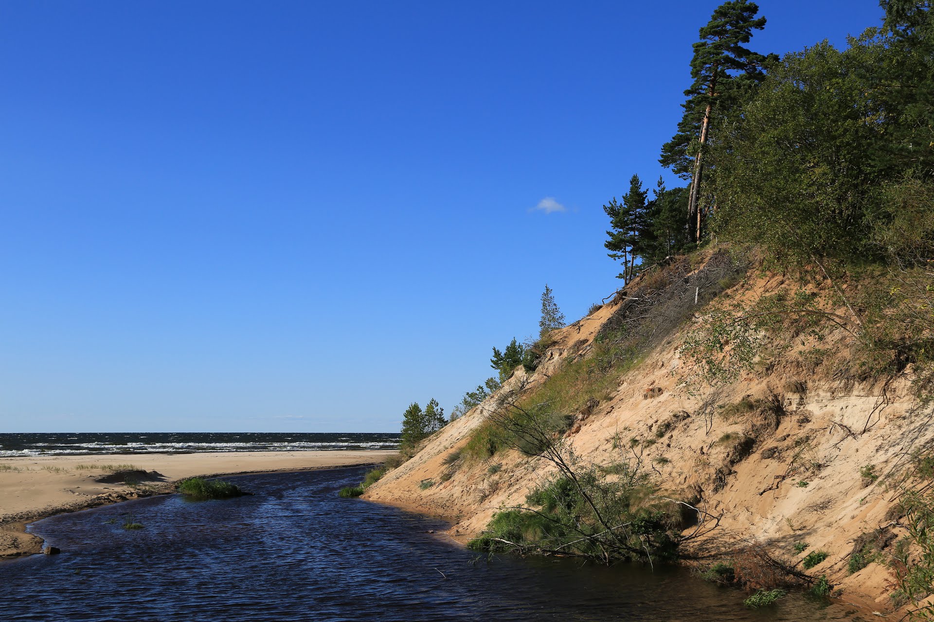
Kāpas baltais, 18 m augstais smilšu atsegums senatnē kalpoja kā orientieris vietējiem zvejniekiem. Baltie smilšu slāņi bija skaidri saskatāmi vēl 20. gs. otrajā trešdaļā. Uzskata, ka Baltā kāpa veidojusies, pāri Baltijas ledus ezera mālainajiem nogulumiem vējam dzenot pludmales smiltis. Pirms 200-150 gadiem kāpa vēja ietekmē pārvietojusies, par ko liecina vairākas kāpas apraktās augsnes kārtas. Baltā kāpa tika dalēji noskalota 1969. g. vētrā, kad jūras pusē izveidojās 4-6 m augsta krauja. Tagad kāpu atkal pielīdzinājušas vēja uzpūstās smiltis. Lai ari kāpa ir nostiprināta ar klūgu pinumiem un apaugusi ar priežu mežu, arvien redzama tās stāvā, uz jūru vērstā nogāze. Kāpas apkārtne ir labiekārtota un sakopta, bet tās nogāzes - nostiprinātas. Kāpas virsotnē 2003. g. ierīkots skatu tornis un skatu laukums.
No kāpas paveras skaists skats uz jūru, Inčupes grīvu un plašo pludmali. Pie Baltās kāpas uzņemti kadri Rīgas kinostudijas mākslas filmām Kā gulbji kalti padebeši iet (1956) un Nauris (1957).
Inčupe sākas Dzelves purva apkārtne. 12 km garumā, ieslēpusies zemos, purvainos un pārplūstošos krastos, tā likumo cauri mežiem, lidz pie Baltas kāpas ieplūst jūrā. Lai arī Inčupe liekas sīka upīte, rudeņos tajā iepeld laši, bet attekās mitinās līdakas. Vēl nesen Inčupes krastos ganījies melnais stārķis.
Pludmale un kāpas, kas kalpojušas kā aizsardzība no krasta, ir noskalotas. Šī iemesla dēļ Saulkrastu kāpu zona un pelēkās dūņas tika daļēji noskalotas. Tās kāpu daļas, kas ir apaugušas ar mežu ir iekļautas Eiropas Savienības aizsargājamo biotopu sarakstā. Īpaši nozīmīgi ir senie kāpu meži, kas ir ļoti reta parādība Latvijā. Šādi meži sastopami arī Saulkrastos, kur priežu audzes sasnied pat 170- 190 gadu vecumu.
The 18 meter high dune was created when wind blew beach sand to the clay bottom of the ancient Baltic Ice Lake. For 200-150 years, the White Dune was a moving dune. In the year 1969, part of the dune had been washed away by a storm. As a result, a gap of 4-6 meters deep had been created. Over the years, the dune got covered with sand, partly overgrown with forest and additionally, it got stabilized by man with braided wicker mats. In 2003, an observation tower and a viewing platform has been built on top of the dune.
The Inčupe River flows from the surroundings of the Dzelves swamp. For 12 kilometers, the river winds its way through low, swampy and flooded banks. It makes curves through the woods and finally flows into the sea at the White Dune. The glacial valley of the river proves that this river was at that time the widest river in Saulkrasti. In its whole course, Inčupe has preserved its natural look because no land improvements and excavations have been made.
At low water level in the fall, salmons come to the Inčupe, pikes are living in the tributaries. Also, black storks can be spotted on the banks of the river. The alluvium which is formed before the western and southern coast of the Gulf of Riga, causes the river to flow north. Heavy northwestern storms cause obstructions or changes to the river bed.
The beach and the dunes serve as protection from the coastline being washed away. Because of this, the front and the gray dunes in the area of Saulkrasti have only been partly preserved. The dunes which have been overgrown with forests, are among the protected habitats of the European Union. Particularly valuable are the ancient dune forests, which are very rare in Latvia. Such forests are also seen in Saulkrasti, where pines can grow more than 170 to 190 years old.
Lai pielāgotu šo slēpni kā atrastu, jums ir jāapmeklē Bālta kāpa, jānoskaidro atbildes uz zemāk dotajiem jautājumiem un jāatsūta tās man uz šo saiti. Savam logam nekādā gadījumā nepievienojiet atbildes!
1. Apskatiet kāpu. Aprakstiet tās krāsas un augošo veģetāciju.
2. Aptuveni 200 gadus Baltā kāpa ir pārvietojusies. Kas par to liecina?
3. Kas izveidoja kāpas stāvo nogāzi?
4. Ne obligāti: būtu jauki, ja jūs pievienotu savu vai savas komandas attēlu pie Inčupes.
Please answer the following questions in order to log the Earthcache. Do not post them here, but instead send them by using this link.
1. Take a look at the dune, and explain the colouring and vegetation.
2. For around 200 years, the Baltā kāpa has been a moving dune. How was this evidenced?
3. What created the dune's steep slope?
4. Optional: it would be nice if you would place a picture of you or your team in front of the Inčupe River.
Additional Hints
(No hints available.)