|
Introduction :
“Craie”, chalk in French, comes from the term "Créta" in Latin and it is a white rock, quite friable, composed of two elements:
- From a biological perspective, this rock is made of more than 50% of coccolith (word coming from the Greek "stone"). These are small circular calcite plates serving as protection of marine unicellular algae: the coccolithophorids.
- From a chemical point of view, it consists of a majority (90%) of calcite (which is one of the crystalline forms of calcium carbonate) and some clay. Calcite is a carbonate which has a role in cementing the rock.
Formation :
The chalk is a sedimentary rock formed by marine remains of unicellular algae "shells". These algae, called coccolithophorids, are part of the foraminifera group. They live in the lagoons where the water is shallow and warm.
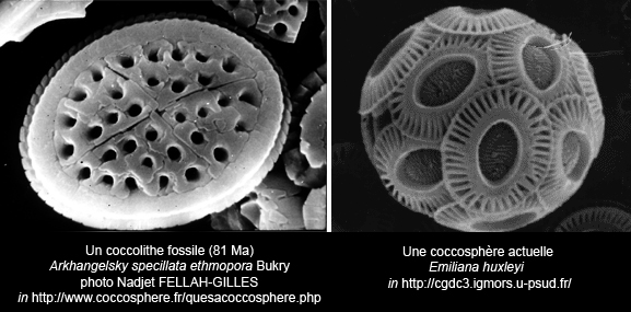
Their test (limestone skeleton) is formed of an assembly of plates, called coccolith, which are made of calcite. To create these plates, they use the calcium dissolved in the water and the hydrogen ions.
When they die, their tests accumulate on the seabed and form a carbonated sludge. Over time, these remains compact and assemble to form a calcite cement.
The Earthcache :
Basement
The basement of the department consists essentially of chalk soils of the Tertiary, soft rock, cracked, with a soluble feature.
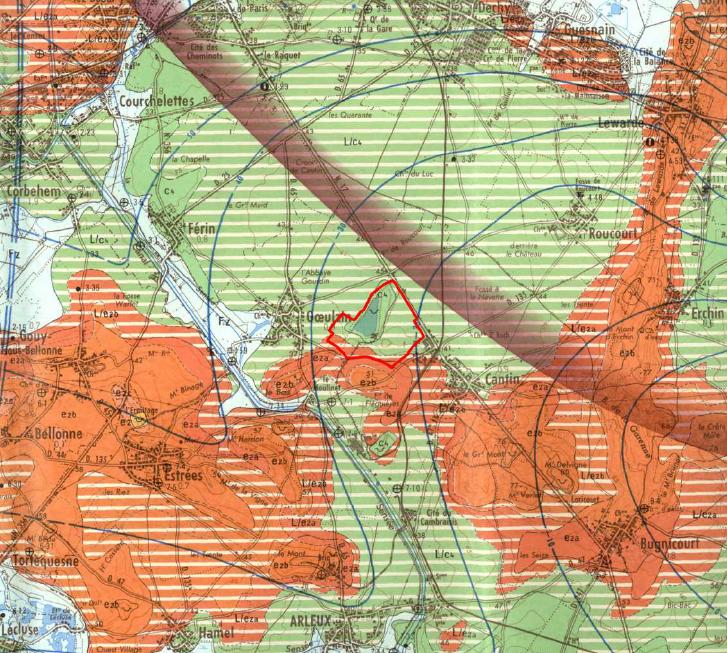
The following geological analysis aims to explain in a simplified manner the geological context that led to the current model of landscape and the existence at the same site of two quarries exploiting different materials: clay and chalk. The different geological strata present in the sector of Cantin are (see map below):
- White chalk of the Senonian, ie from the period 88 million years to 65 million years ago (Late Cretaceous, Secondary era). This set of poor white chalk flint measures thirty meters deep. This chalky set lays on the marl of the Middle Turonian, and then on plastic marls of Lower Turonian (-92 to -88,000,000 years).
- In the south remain some mounds of clay or sand (Landenian or Thanetian) formed during the Tertiary.
In Quaternary, yellowish silt were deposited on these upland areas and covered several meters of the white chalk Senonian.
From the structural point of view, the chalky formations from the Cretaceous sink slowly to the northeast, towards the Bay of Orchies.
Geomorphologie
The natural morphology of the area is the one of a flat ground. The digging of the chalk quarry has created cliffs, slopes and a fringe where the banks are directly accessible.
Cliffs
High of 15 to 20 m, they have an almost vertical profile with the layer of chalk visible, covered by a softer layer having a profile at 45°.
Vegetation tends to make the vertical parts imperceptible. These cliffs are particularly dangerous for their configuration. As chalk is not a frost-resistant rock, it is necessary to take into account the risk of collapse of the walls.
Banks
They are most often of sand, rather steep (45 °) and high from 2 to 4 meters, they represent no significant danger. They correspond to the first extraction layer (such as cliff tops). Around the lake, they form a natural barrier.
Reminder on "Earthcaches": There is no container or logbook on the given coordinates. Just visit the site and answer the questions by e-mail. There is no need to wait for my reply, feel free to log immediately after. If the answers are incorrect, I will let you know. Happy caching!
To validate your visit:
1-. Reading the description, what types of soils form the Cantin Lake?
2-. From what is chalk created?
3-. Why the extraction of clay and chalk is stopped (explain it in a few words)?
4-. How many meters long is the yellow pedestrian path?
You can contact me in: English, French, Catalan or Spanish.
|