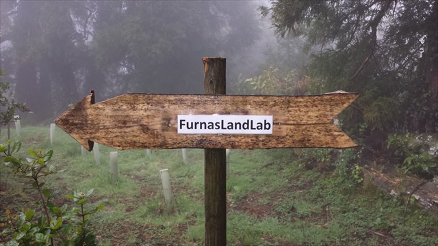
FURNAS LANDSLAB
PT 3/11 – TRILHO DO PLANALTO
Português

FURNAS LANDSLAB
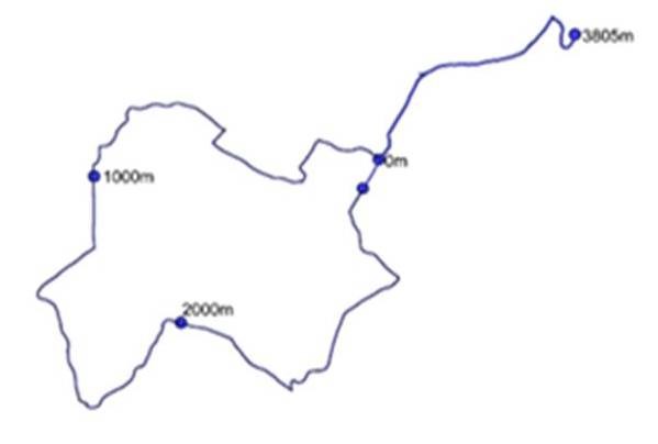
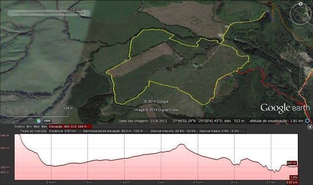
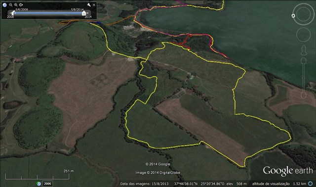
Este power-trail pretende divulgar o Laboratório de Paisagem das Furnas, que se insere na área de Paisagem Protegida das Furnas, do Parque Natural da Ilha de São Miguel. Este PT é constituído por 12 caches (11 caches tradicionais e 1 cache-enigma bónus). O PT é constituído pelo trilho do Pico do Ferro, o trilho do planalto e o trilho da Grená. Recomendamos que seja percorrido de forma circular, começando e terminando na zona das caldeiras da Lagoa das Furnas. Numa situação “normal” será percorrido em cerca de cinco horas.
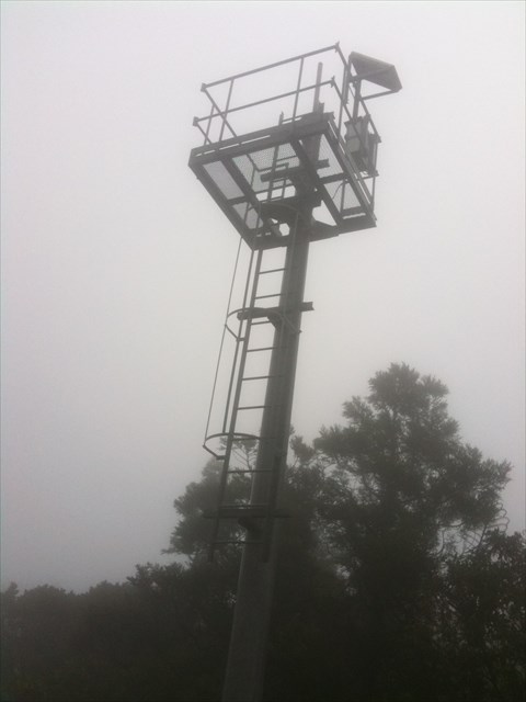
Na zona do planalto, poderão visitar: a Floresta Encantada, a Serpentina, Os Arboretos do Reinfforce, a ICCA (International Congress and Convention Association), o MIT GREEN ISLANDS – WOODY BIOMASS/ Pomares de Uva-da-Serra e o SATA Forest. Também poderá visitar o PTLogo.
TRILHO DO PLANALTO
O aumento de consciência ecológica e a visível degradação da paisagem, em termos estéticos e ecológicos, na massa de água e nas terras envolventes de uma zona tão emblemática das ilhas e um hotspot do turismo açoriano, foi o motor da criação de uma legislação rigorosa.
O Plano de Ordenamento da Bacia Hidrográfica da Lagoa das Furnas (POBHLF) tem como objetivo principal a recuperação da qualidade da água da lagoa, cumprindo-se assim a Diretiva Quadro da Água.
As principais linhas de orientação do Plano de Ordenamento que guiaram todas as ações implementadas foram:
· Reduzir as cargas afluentes à lagoa;
· Aumentar a biodiversidade
· Salvaguardar a sustentabilidade dos rendimentos
· Diversificar e consolidar a base económica local;
Assim nasceu o Laboratório de Paisagem das Furnas(Furnas LandLab), que obedece às medidas do POBHLF e da Área de Paisagem Protegida das Furnas. A qualidade da paisagem e a sustentabilidade em todas as vertentes – ecológica, económica, social, cultural e estética – é o seu paradigma de referência.
O Laboratório de Paisagemé o homólogo dos parques tecnológicos, mas vocacionado para o campo das Ciências Naturais. Em vez de laboratórios e escritórios num edifício, existem canteiros e talhões experimentais ao longo da paisagem.

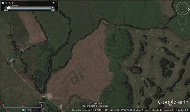
Fundação PT, foi plantada uma área de um hectare (100m X 100m) que se denomina o PTLogo, e que é uma representação no terreno do logótipo da empresa. As áreas azuis deste logo foram plantadas com cedro-do-mato (Juniperus brevifolia), uma espécie endémica cujos rebentos anuais são de coloração azulada. É uma parceria que envolveu diretamente cerca de 70 funcionários da PT e respetivos familiares numa ação de voluntariado e Teambuilding. A divulgação desta ação no seio do grupo PT, deu a conhecer este projeto e o Furnas LandLab aos 10.000 funcionários da PT presentes no Pavilhão do Atlântico para o jantar de Natal de 2010.
O cedro-do-mato é uma espécie de crescimento relativamente lento, mas têm sido realizados cortes de erva que já permitem visualizar o logótipo da PT, apesar de as árvores ainda não terem a dimensão necessária, para esse efeito. Atualmente o PTLogo já é visível através do GoogleEarth, ou do topo dos domos vulcânicos adjacentes.
LABORATÓRIO DE PAISAGEM DA LAGOA DAS FURNAS
A Unidadede Paisagem da Lagoa das Furnas: é o extenso plano de água, complementado pela existência das caldeiras e fumarolas a Norte, que centralizam a composição desta paisagem e determinam a existência de elevadas potencialidades para o recreio e lazer. Ao longo da sua margem foram-se estabelecendo as atividades humanas de produção e de lazer, ocupando uma estreita faixa de contacto entre o plano de água e as vertentes abruptas que a limitam. Aqui localizam-se importantes valores culturais que testemunham a evolução desta paisagem e que constituem importantes elementos patrimoniais representativos da arte paisagística do séc. XIX: a Mata de José do Canto e a Mata da Grená. Posteriormente, assistiu-se à construção, nestas margens, de residências de veraneio com os respetivos jardins. As terras altas da Achada das Furnas integram esta unidade, que apresenta várias subunidades enunciadas na Fase B da elaboração do Plano de Ordenamento da Bacia Hidrográfica da Lagoa das Furnas.
A Área de Paisagem Protegidadas Furnas, com 3150 ha, situa-se no interior de uma caldeira que resultou do colapso da estrutura de um dos vulcões mais ativos de São Miguel, o vulcão das Furnas. A geomorfologia e hidrologia singular desta caldeira conduziram à classificação desta área como área de paisagem protegida. Destacam-se na paisagem, a lagoa das Furnas e os fenómenos de vulcanismo secundário, tais como os campos fumarólicos e as nascentes de águas termais.
O Laboratório de Paisagemé o homólogo dos parques tecnológicos, mas vocacionado para o campo das Ciências Naturais. Em vez de laboratórios e escritórios num edifício, existem canteiros e talhões experimentais ao longo da paisagem. Os estudos e as experiências, conduzidas ao ar livre, abarcam disciplinas como a Silvicultura, a Agronomia, a Horto-Fruticultura, a Biologia, a Ecologia, a Bioengenharia, a Biotecnologia, a Psicologia Ambiental, o Paisagismo, a LandArt e o Turismo.
A CACHE:

A caixa tem um formato NÃO convencional.
Deve levar consigo material de escrita.
Por favor, não nem postem fotos que possam denunciar a cache.


FURNAS LANDSLAB
PT 3/11 – “PLANALTO” TRAIL
ENGLISH

FURNAS LANDSLAB
This power-trail intends to promote Furnas Landscape Laboratory, which is included in the protected landscape area of Furnas, the Natural Park of São Miguel Island. This PT consists of 12 caches (11 traditional caches and cache 1-puzzle bonus). The PT consists of the Iron Peak Rail, the rail and the rail plateau of Garnet. We recommend that you traveled in a circular fashion, beginning and ending in the area of boilers of Lagoa das Furnas. In a "normal" situation is traversed in about five hours.
In the area of the plateau can visit: the Enchanted Forest, the Streamer, arboreta of REINFFORCE, the ICCA (International Congress and Convention Association), MIT GREEN ISLANDS - WOODY BIOMASS / Orchards Grape-of-Serra and the SATA Forest. You can also visit the PTLogo.
“PLANALTO” TRAIL
Increased environmental awareness and the visible landscape degradation in aesthetic and ecological terms, in the water and surrounding land such emblematic area of the islands and an Azorean tourism hotspot, was the driving force behind the creation of strict legislation.
The Plan of Planning of the Hydrographic Basin of Lake Furnas (POBHLF) aims to recover the pond water quality, thus fulfilling up to the Water Framework Directive.
The main guidelines of the development plan that guided all the actions taken were:
· Reduce loads tributaries to the pond;
· Increase biodiversity
• To safeguard the sustainability of income
• Diversify and strengthen the local economic base;
Thus was born the Landscape Laboratory Furnas(Furnas LandLab), which follows the steps of POBHLF and Protected Landscape Area of Furnas. The quality of the landscape and sustainability in all aspects - ecological, economic, social, cultural and aesthetic - is your reference paradigm.
The Landscape Laboratoryis the same technology parks, but devoted to the field of Natural Sciences. Instead of laboratories and offices in a building, there are experimental plots and plots across the landscape.
PT Foundation, was planted an area of one hectare (100m x 100m) which is called the PTLogo, and that is a representation on the company logo of the land. The blue areas of this logo were planted with cedar-eating fox (Juniperus brevifolia), an endemic species whose annual shoots are bluish. It is a partnership that directly involved about 70 employees of PT and respective family members in a voluntary action and Teambuilding. Disclosure of this action within the PT Group, informed this project and the Furnas LandLab to 10,000 employees of PT present in the Atlantic Pavilion for the 2010 Christmas dinner.
The cedar of the woods is a relatively slow-growing species, but have been conducted grass courts already let you see the logo of PT, although the trees have not yet the size required for this purpose. Currently the PTLogo is already visible through the GoogleEarth, or the top of the adjacent volcanic domes.
LABORATÓRIO DE PAISAGEM DALAGOA DAS FURNAS
The Landscape Unit of Lagoadas Furnas is the extensive water plan, complemented by the existence of boilers and fumaroles the North, that centralize the composition of this landscape and determine the existence of high potential for recreation and leisure. Throughout its margin were being established human activities of production and leisure, occupying a narrow contact zone between the water level and the abrupt slopes that limit. Here are located important cultural values that testify to the evolution of this landscape and that are important representative assets of the landscape art of the century. XIX: Joseph corner of Forest and Forest Garnet. Later, saw the construction, these margins of summer residences with the respective gardens. The highlands of Pembrokeshire Furnas part of this unit, which has several subunits set out in Phase B of the preparation of the River Basin Management Plan Lagoa das Furnas.
The Protected Landscape Area of Furnas,with 3150 ha, is located in the interior of a crater that resulted from the collapse of the structure of one of the most active volcanoes of São Miguel, the Furnas volcano. The geomorphology and hydrology of this singular boiler led to the classification of this area as a protected landscape area. Stand out in the landscape, the lagoon of Furnas and the phenomena of secondary volcanism, such as fumarolic fields and of the thermal springs.
The Landscape Laboratoryis the same technology parks, but devoted to the field of Natural Sciences. Instead of laboratories and offices in a building, there are experimental plots and plots across the landscape. The studies and experiments conducted outdoors, cover subjects such as Forestry, Agronomy, the Horto-Fruits, Biology, Ecology, Bioengineering, Biotechnology, Environmental Psychology, the landscaping, the LandArt and Tourism.
THE CACHE:
The box has a NO conventional format.
You should carry written material.
Please do not to post pictures that can report the cache.