

NOTE: This is an earthcache, there is no physical container to find. To get your smiley for the cache, e-mail your answers for the questions below to the cache owner.
This earthcache can be completed on board a ship or anywhere around the bay as long as you can see the tombolo. The actual earthcache coordinates are located outside the Falmouth port gates and are accessible to the public. If you are arriving by car please park across the street in the lot (N 18 29.299, W 77 38.980) and walk across the road safely. The port has asked us not to park on the water side of the road. If you are within the port gates and you would like to go out to the earthcache coordinates you will need to go out and in the main public entry/exit at (N 18 29.537, W 77 39.072). The gates right near the earthcache coordinates are for buses and do not allow public entry/exit. Permission for placement is from Mark A. Hylton Falmouth Cruise Ship Terminal Port Authority of Jamaica.
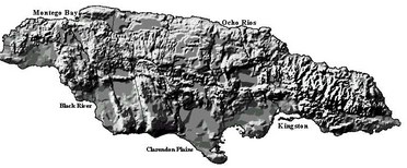
The Island of Jamaica:
Jamaica is the third largest island in the Greater Antillean archipelago. The island of Jamaica is 147 miles long and 50 miles wide. The island was first formed by an arc of ancient volcanoes that rose out of the sea millions of years ago. An interesting fact about the island of Jamaica is that it is tilted with the northern coast being pushed up. Due to this tilt the northern coast experiences more erosion and has rugged coastline with wave cut cliffs, arches, sea caves and inlets. In contrast the southern coast is mostly depositional and has more plains and black sand beaches.
Bays:
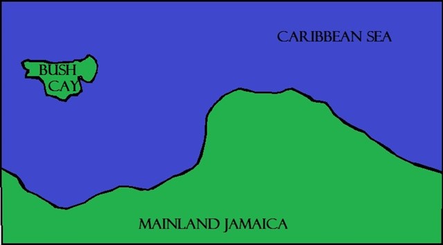
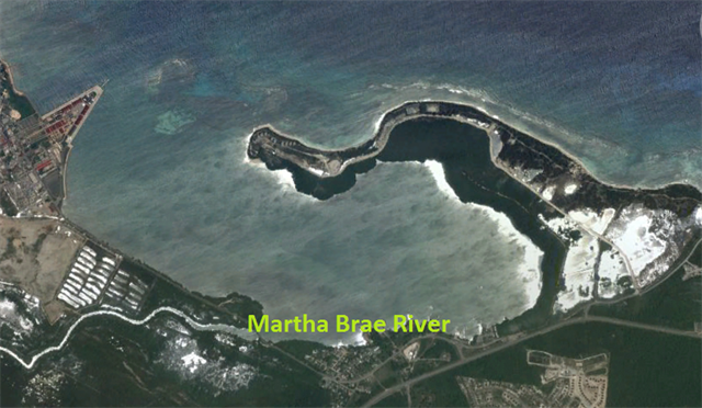
A bay is defined as a body of water partially surrounded by land. Bays can also be called lagoons, sounds, and bights. Most bays have brackish water. Brackish water is water that has a greater salt content than fresh water, but not as much salt as the ocean. The bay you are viewing for this earthcache is called Oyster Bay. Sometimes it is also referred to as Glistening Waters Luminous Lagoon due to the tiny bio-luminescent micro-organisms that glow and emit a blue light when disturbed or agitated at night. They bay is bordered on the north by a peninsula called Bush Cay. Bush Cay wasn’t always as you see it now, connected to Jamaica, and this is where our story begins.
Bush Cay used to be an island off of Jamaica:
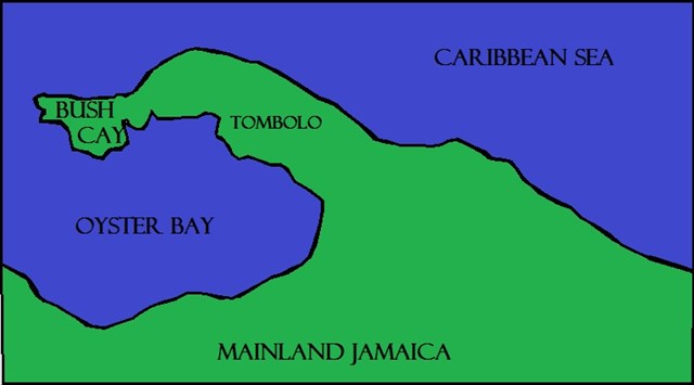
The Forming of Oyster Bay:
The action of long shore current straightens coastlines due to the creation of barriers, barriers slowly cut off bays from the sea. As the long shore current moved sediment west from the main island of Jamaica towards Bush Cay island, the gap between them filled up. The geological term for a feature that is built when an island is attached to the mainland is called a TOMBOLO. When the mainland of Jamaica became attached to Bush Cay island it formed the North boundary of Oyster Bay. The South boundary of oyster bay is formed by the island of Jamaica itself.
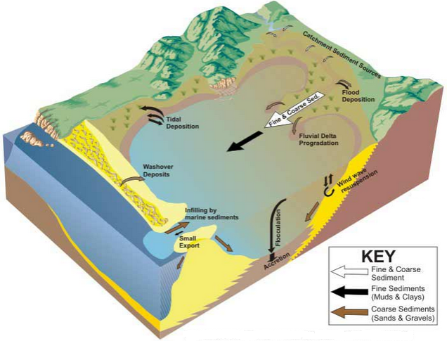
Sediment Transport in Bays:
Sediment that moves down a river and is deposited into a bay is both fine and coarse. Coarse sediments which usually consist of gravel and sand are deposited at the head where the river meets the bay and also sink to the bottom of the bay. Fine sediment which usually consists of muds, clays, and organic materials flow down to the center of the bay and are deposited along the edges of the bay. At the entrance where the ocean water comes into the bay tidal water moves coarse sediments of sand and gravel from the ocean into the bay. Fine sediments such as muds, clays, and organic material flow out into the ocean but at a much slower rate than the coarse sand and gravel coming in. The exception to more sediment going out the inlet than coming in is during spring tides or flood events.
Sediment and Oyster Bay:
Sediment is moved on the outside of the peninsula (ocean side) by long shore current and wind. In contrast sediment on the inside of the bay is moved by current which is created by the nearby Martha Brae River flowing into the bay. The Martha Brae River flows into Oyster Bay through an large wetland system which is found along the limestone foothills that run parallel to the coastline. As The River empties into Oyster Bay it brings silt. This silt overtime has become highly compacted and is known to extend to depths of 100 feet. Currently the floor of the bay is flat and the water is rather shallow with a depth of typically 3-15 feet. Due to the constant flow of the Martha Brae River and because the waves in the bay are weaker and are unable to move sediment out of the bay as quick as it comes in, sediment in the bay is building up, which leads to some questions....
To get credit for the cache, please answer the questions below. When answering the questions do your best. It is more important that you learn a new concept about our earth and can apply your knowledge, rather than have a precise answer.
Questions:
1- At the time of your visit, estimate the width of the opening between the tip of Bush Cay and the tip of the port dock.
2- Considering how Oyster Bay was formed, what is your prediction for its future shape, say 200 years from now?
3- Which do you believe is the main force that will change its shape (The ocean and/or The Martha Brae River)? Please give your reasoning.
Thank you for visiting this earthcache. Please send your answers to the above questions to the cache owner. In your "found it" log feel free to write about your experience, but don't include the earthcache answers. Thanks and we hope you enjoy beautiful Jamaica!

Sources:
http://en.wikipedia.org/wiki/Geography_of_Jamaica
http://faculty.gvsu.edu/videticp/longshore.htm http://en.wikipedia.org/wiki/Tidal_range
https://www.elaw.org/system/files/OysterBayEIA-Report.pdf
http://www.scubanautsintl.org/teacher/dbml_field_guide_final.pdf
http://gsj.monainforma
http://www.scubadivejamaica.com/glistening-waters-luminous-lagoon-in-jamaica/tixltd.com/trelawny.html
http://www.discoverjamaica.com/gleaner/discover/geography/features.htm
http://fotajam.net/didyoukno1.html
http://en.wikipedia.org/wiki/Tombolo
https://ih-igcse-geography.wikispaces.com/2.2.+Coastal+features
http://cruisejamaica.com/
http://education.nationalgeographic.com/education/encyclopedia/bay/?ar_a=1
http://www.ozcoasts.gov.au/conceptual_mods/geomorphic/wde/wde_sed_trans.jsp