Svensk version:
För att logga cachen skall du skicka svaren på följande frågor till adressen du finner på min profilsida (skicka meddelande):
1.Är stenarna i åkern kantiga eller runda? Varför tror du de har den form de har?
2.Varför tror du att det inte finns någon vegetation förutom mossor och lavar på det här klapperstensfältet.
3.Hur stora är stenarna på koordinaterna? Då menar jag stenarna under dina fötter när du står på koordinaterna.
4.Varifrån har Yoldiahavet fått sitt namn?
Ladda inte upp bilder av stenåkern i din logg!
Du kan logga meddetsamma, men jag kommer att radera loggar där inget svar kommit in. Om svaren är fel kommer jag att kontakta dig.
Postglacial landhöjning är landhöjning orsakad av att jordskorpan återvänder till ett mekaniskt viloläge efter att ha befriats från tryck av inlandsis.
I slutet av senaste istiden var delar av norra Europa och Nordamerika täckta av ett upp till 4 km tjockt istäcke. Isen pressade genom sin tyngd ner jordskorpan i manteln. När isen smälte undan, började landet stiga igen. På grund av jordmantelns höga viskositet tar denna process tusentals år.
Forskning har visat att landhöjningen inledningsvis var omkring 75 mm/år. Denna fas pågick i cirka 2 000 år, då isen tunnades ut och drog sig undan. När isen hade försvunnit, minskade landhöjningen till cirka 25 mm/år, och avtog sedan exponentiellt. Landhöjningen beräknas pågå i cirka 10 000 år till. Där landhöjningen idag är som störst kan 50–100 m landhöjning återstå. Exempelvis beräknar man att Kvarken kommer att torrläggas, vilket leder till att Bottenviken blir en sötvattenssjö med älvförbindelse till Bottenhavet.
Östersjön är, ur geologiskt perspektiv, mycket ung. Under de senaste 12 000 åren har detta vattenområde växlat från smältvattensjö till atlantvik till insjö till brackvattenhav. Detta har genom årtusendena medför stora påfrestningar på de djur och växter som försökt leva här.
Under de senaste ca 2,5 miljonerna år, den så kallade kvartärperioden, har Norden varit täckt av mäktiga inlandsisar vid ett antal tillfällen. I dag anses det att den senaste istiden började uppe i den skandinaviska fjällkedjan för ca 115 000 år sedan.
För ungefär 22 000 år sedan nådde isen sin maximala utbredning och kort efter det började inlandsisens avsmältning. Isavsmältningen skedde i djupt vatten och isbergskalvningen var effektiv, så att isfrontens reträtt var snabb. Med några hundra meter per år frilades Åland från is för ca 11 000 år sedan, men låg då ännu under havet.
Det vi kallar Yoldiahavet fanns för ca. 11 500-10 700 år sedan och uppvisar en öppning mot Atlanten. Det stora utflödet av smältvatten hindrade saltvatten från att komma in trots den vid det här laget ganska stora öppningen mot Atlanten. Vid slutet av nedisningen, under senaste istid för ca. 10 000 år sedan, låg hela Åland täckt av vatten. När isen försvann började Åland resa sig ur Yoldiahavet. Först upp var Orrdalsklint (129 m. ö. h), Ålands högsta berg, följt av Långbergen båda i Saltviks kommun. Landhöjningen är idag vertikalt 4-5 mm/år.
Stenåker, ej den som är aktuell i cachen
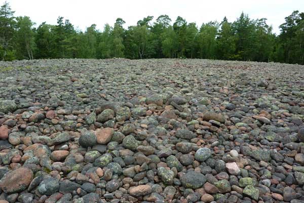
Stenåkrar, Stentorg, Klapperstensfält
När man rör sig på höjder omkring 100 m.ö.h på Åland hittar man ofta stenåkrar (klapperstensfält eller häxåkrar) med strandterrasser vid sidan av högre berg. Klapper är stenar och mindre block som slipats och nötts av vågorna och blivit släta och rundade. Namnet kommer från det klapprande ljud som uppstår när stenarna slår mot varandra under vågornas inverkan. Ett stentorg är en fossil strand, en strand som på grund av landhöjningen tappat kontakten med havet och inte längre påverkas av vågorna. Det är det ursvallade ytskiktet av morän som sköljdes av havet, när havet blev till strand i samband med landhöjningen. På de högsta höjderna är det strandlinjer från Yoldiahavet som vi idag ser som stenåkrar. Det finns flera större och mindre stenåkrar i området.
Några meter under ytan kan man se att underlaget utgörs av morän, det vill säga ett mer osorterat material med olika partikelstorlekar. Stenåkrarna saknar oftast högre vegetation, men dom är täckta av skorplavar i olika vackra färgnyanser. Titta på lavarna på nära håll, riktiga små konstverk.
Var försiktig och rubba inte några stenar. Om man vänder på dem förstörs ofta lavarna och det kan ta hundratals år att återbilda dem.
Vid koordinaterna står du vid kanten av ett stort Stentorg.
Uppe på Ålands högsta berg, Orrdalsklint, (höjden är 129,1 m ö.h.) finns flera geocacher, som man kan nå via promenader. Det är ett ganska svårorienterat område utan ordentliga markeringar. Från Orrdalsklint kan man hitta till denna earthcache via en stig. Den stigen går sedan vidare mot Grottan (den cache som kallas Orrdalsklint). Så om du vill besöka Grottan, kan du gå förbi den här earthcachen. En annan startpunkt kan vara stage 2 i waypointlistan.
English version:
Send answers to me via my profile. You can log right away, but I will delete the logs, where no answer is received. If the answers are wrong, I will contact you.
1. Are the stones of the field angular or round? Why do you think they have that shape?
2. Why do you think there is no vegetation except mosses and lichens in this shingle field?
3. How big are the stones at the coordinates? Here I mean the stones you stand on when you are at the koordinates.
4. From where did the Yoldia Sea get its name?
Don't upload any pictures of the shinglefield described in this cache!
You can log right away, but I will delete the logs, where no answer is received. If the answers are wrong I will contact you.
Shingle fields at Orrdalsklint
Post-glacial land elevation is uplift caused when the earth's crust returns to a mechanical rest position after having been freed from the pressure of the ice sheet.
At the end of the last ice age parts of northern Europe and North America were covered by a 4 km thick ice cap. By its weight, the ice pressed down the crust into the mantle. When the ice melted, the land began to rise again. Due to high viscosity of the earth mantel, this process takes thousands of years.
Research has shown that uplift was initially about 75 mm / year. This phase lasted approximately 2000 years, as the ice thinned out and retreated. When the ice had disappeared the uplift decreased to about 25 mm / year, and then declined exponentially. The land uplift is expected to last for about 10,000 years. Where uplift today is the greatest, 50-100 m uplift can still remain. For example, it is estimated that the Quark will be drained, leading to the Gulf of Bothnia becomes a freshwater lake with river connection to the Bothnia Sea.
The Baltic Sea is, from a geological perspective, very young. Over the past 12,000 years this body of water changes from a lake of melted water, to a gulf of the Atlantic Ocean, to inland lake, to brackish water. This has been a big strain to the animals and plants that have tried to live here through the millennia.
Over the past about 2.5 million years, known as the Quaternary period, the Nordic countries have been covered by mighty ice sheets on a number of occasions. Today it is considered that the last ice age started in the Scandinavian mountain chain about 115 000 years ago.
About 22 000 years ago the ice reached its maximum extent and shortly after that the deglaciation began. The deglaciation occurred in deep water, and the retreat of the ice front was fast. 11 000 years ago the ice retreated from the area with some hundred meters per year, but it was then still under the sea.
What we call Yoldia Sea existed for approximately 11500-10700 years ago and has an opening towards the Atlantic. The large outflow of meltwater prevented salt water from entering, despite the, by now, quite large opening towards the Atlantic. At the end of glaciation during the last ice age ca. 10,000 years ago the whole of Åland was covered by water. When the ice disappeared Åland began to rise from the Yoldia Sea. First up was Orrdalsklint (129 m asl), Åland's highest mountain, followed by Långbergen both in the community of Saltvik. The land uplift is today vertically 4-5 mm / year.
A shingle field (not the one described here)
Shingle fields (Swedish Stenåkrar, Klapperstensfält)
When moving at elevations around 100 meters above sea level in Åland you often find stone fields (shingle fields) with beach terraces alongside the higher mountains.Swedish “Klapper” are rocks and small blocks that were polished and worn by the waves and become smooth and rounded. The name comes from the rattling noise that occurs when the stones hit against each other during the wave impact. A “stone square” is a fossil beach, a beach, that due to uplift, lost contact with the sea and is no longer affected by the waves. Shingle fields are swelled surface layers of moraine that was washed by the sea, when the sea became beach during the uplift. At the highest elevations, the shorelines of the Yoldia Sea are what we today see as shingle fields. There are several large and small shingle fields in the area.
A few meters below the surface, one can see that the substrate consists of moraine,that is a more unsorted material with different particle sizes.
Shingle fields often lack higher vegetation, but they are covered by crustose lichens in various beautiful shades. Look at the lichens at close range, real works of art.
Be careful not to dislodge any stones. If you turn them, the lichens are often destroyed, and it can take hundreds of years to regenerate them.
At the coordinates you stand at the edge of a large Shingle field.
Up on the highest hill in Åland, Orrdalsklint, (elevation is 129.1 m asl) are several geocaches, that can be reached by walking. It is a rather difficultly oriented area without proper markings. From Orrdalsklint you can find your way to this earth cache via a path. The trail continues towards cave (the cache called Orrdalsklint). So if you want to visit the cave, you can pass this earth cache. Another starting point might be Stage 2 in the waypoint list.
Källa/Source: Carlsson, Ralf, Åland – Grundkurs i kvartärgeologi inom en liten yta. Geografiska Notiser • Årgång 71 (2013) • Nummer 1