english version 
The Geology of Karpathos - or: what is a rejection ?
With the exception of the extreme south, where expands a larger level, Karpathos is very mountainous.
A powerful ridge cross the island, existing mainly from various limestone and flysch.
To the north it takes more and more bizarre and grandiose forms and continues in the island of Saria.
Steep fall off the edges, from which the sea has been eaten coves and caves.
Its highest elevation reached this rugged mountain range in Kali Limni, with 1,215 meter race at the highest mountain in the Dodecanese.
Limestone, that means you walk on the Mesozoic; a more than 100 million years ago formed seabed.
In the early Tertiary, which was 70 to 20 million years ago, this seabed was raised gradually
by forces within the earth or under the pressure of African raised to the Eurasian plate.
Karpathos was part of a young mountain folds, which stretched from the Peloponnese to the present day Turkey.
In the late Tertiary, million before 20 to 2 years, it came as a result of the uplift of the Alps and the pressure of the various tectonic plates again to massive earthworks.
Along faults (geological fault lines) the \\\\\\\"Aegean Country\\\\\\\" broke in a mosaic of individual floes, the different depths be raised again, and then come down again to a large extent.
From the south, the Mediterranean, the area was flooded and thereby created about the current form of the Aegean Sea.
What stands out today as islands fact, only the volcanic islands, as there are Santorini or Nissiros.
The Earth is not resting in this area until today :
Greece has an annual average of about 270 earthquakes, of which, however, most can only be measured with sensitive equipment.
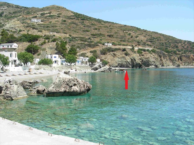
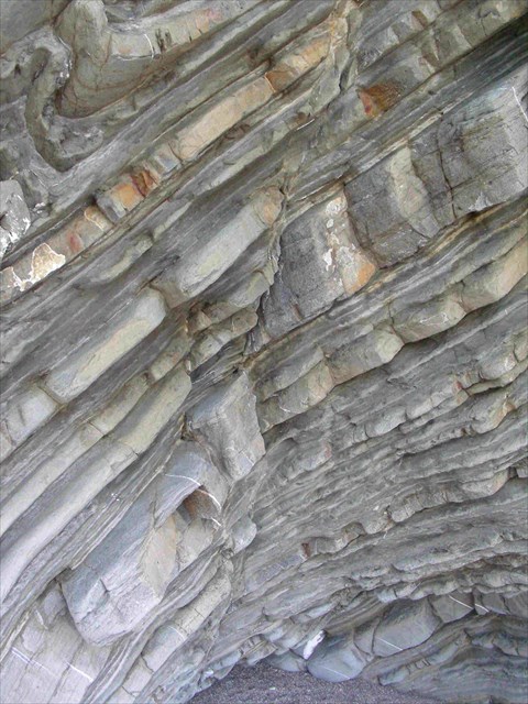
This EarthCache show you a impressive rejection of the limestone mountains and you can imagine the big forces from the inner earth which are working in this area.
But what is a rejection ?
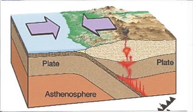
A rejection is a planar fracture or discontinuity in a volume of rock, across which there has been significant displacement along the fractures as a result of earth movement. Large faults within the Earth\\\'s crust result from the action of plate tectonic forces, with the largest forming the boundaries between the plates, such as subduction zones or transform faults. Energy release associated with rapid movement on active faults is the cause of most earthquakes.
A fault line is the surface trace of a fault, the line of intersection between the fault plane and the Earth\\\'s surface.
Since faults do not usually consist of a single, clean fracture, geologists use the term fault zone when referring to the zone of complex deformation associated with the fault plane.
The two sides of a non-vertical fault are known as the hanging wall and footwall. By definition, the hanging wall occurs above the fault plane and the footwall occurs below the fault. This terminology comes from mining: when working a tabular ore body, the miner stood with the footwall under his feet and with the hanging wall hanging above him.
To log this EarthCache, please answer the following questions:
- What direction has this rejection (North-South / East-West / ????? )
- How strong do you think is the inclination of the rejection ?
- Can you find differences between the single layer ?
- Describe the look of the layers ( color, structure, how does it feel to the material )
Please send the answers to our profile or to Teamchritho@go4more.de
You can log the cache immediately, we will contact you if there was anything wrong.
Sources: Karpathos, Antje & Gunther Schwab, Michael Müller Verlag GmbH, Erlangen, 2007
Marc Szeglat • Oberhausen
wikipedia
greek version 
Geo̱logía ti̱s Karpáthou - í̱ :̱ Ti eínai to sfálma ?
Me exaíresi̱ to akraío nóto , ópou epekteínei éna megalýtero epípedo , i̱ Kárpathos eínai polý oreinó.
Éna ischyró , kyrío̱s apó diáfores asvestólitho kai flýschi̱ ypárchon koryfogrammí̱ diaschízei to ni̱sí .
Paírnei sta vóreia ólo kai pio paráxenes kai megaloprepeís morfés kai synechízetai sto ni̱sí ti̱s Sarías .
Apótomes pésoun ta ákra , apó to opoío i̱ thálassa échei fáei ormískous kai spi̱liés .
Sto ypsi̱lótero si̱meío tou fthásei se af̱tó to oroseirá sti̱n Kalí̱ Límni̱ , me 1.215 métro̱n koúrsa sto ypsi̱lótero vounó ti̱s Do̱dekaní̱sou .
Asvestólithos , pou si̱maínei óti boreíte na perpatí̱sete sto Mesozo̱ikoú ?̱ chrónia prin , páno̱ apó 100 ekatommýria pou prokýptoun gýro̱ apó pró̱i̱n vythó , i̱ opoía í̱tan 70 me 20 ekatommýria chrónia prin , stis archés ti̱s dekaetías Tritováthmia , apó tis dynámeis ti̱s mésa sti̱ gi̱ í̱ káto̱ apó ti̱n píesi̱ ti̱s Afrikí̱s stadiaká na af̱xi̱theí i̱ ev̱rasiatikí̱ pláka .
Kárpathos í̱tan méros enós nearoú vounó ptychó̱seis , i̱ opoía ekteinótan apó ti̱n Pelopónni̱so méchri sí̱mera i̱ Tourkía .
Sta téli̱ ti̱s Tritováthmias , ekatommýria prin apó tis 20 éo̱s 2 éti̱ , í̱rthe o̱s apotélesma ti̱s anátasi̱s to̱n Álpeo̱n kai ti̱n píesi̱ to̱n diafóro̱n tektonikó̱n plakó̱n kai páli se mazikés cho̱matourgikés ergasíes .
Mazí vláves ( rí̱gmata ) éspase to «Aegean Chó̱ra \" se éna mo̱saïkó to̱n atomikó̱n onkópagoi , ta diaforetiká váthi̱ absenkten na af̱xi̱theí kai páli , kai sti̱ synécheia na katévei kai páli se megálo vathmó .
Apó ti̱ nótia , ti̱ Mesógeio , i̱ periochí̱ pli̱mmýrise kai étsi di̱miourgí̱thi̱ke schetiká me ti̱n tréchousa morfí̱ tou Aigaíou .
Af̱tó pou xecho̱rízei sí̱mera o̱s ta ni̱siá pragmatikóti̱ta , móno ta i̱faisteiaká ni̱siá , di̱ladí̱ i̱ Santoríni̱ í̱ i̱ Nísyros
Óti i̱ Gi̱ eínai polý na mi̱n érthei se af̱tó to do̱mátio gia na xekourastoún , deíchnoun ta pollá seismoús .
I̱ Elláda échei katá méso óro eti̱sío̱s perípou 270 seismoús , to̱n opoío̱n , ómo̱s , oi perissóteroi boreí na metri̱theí móno me ev̱aísthi̱to exoplismó .
Af̱tó earthcache sas deíchnei energoún me entypo̱siakó trópo póso ischyrí̱ eínai oi dynámeis ti̱s Gi̱s sti̱n periochí̱ af̱tí̱ sí̱mera kai óles oi oreinés si̱kó̱sei gia na schi̱matísoun exárthro̱si̱ .
Allá ti akrivó̱s eínai éna sfálma ?
Éna sfálma ( spasména , álma , kíni̱si̱ , í̱ diatarachí̱ ypó ti̱ stení̱ énnoia tou órou) eínai éna tektonikó schisméno , kátagma sto vrácho , se merikés dekádes í̱ ekató chiliómetra í̱ dýo periochés ti̱s rok tmí̱mata floioú prostíthetai se apostáseis ekatostá kymaínontai méchri sí̱mera .
Af̱tés oi periochés onomázontai fterá rok kátagma , blok , í̱ blok .
I̱ metatópisi̱ af̱tí̱ anaféretai o̱s ýpsos álma kai álma apóstasi̱ .
Enó̱ o genikós óros diatarachí̱ se mia ev̱rýteri̱ énnoia , diáforoi týpoi plastikí̱s paramórfo̱si̱s boreí na perilamvánei ti̱ chrí̱si̱ móno to apotélesma enós ylikoú thráf̱si̱s paramórfo̱si̱ onomázetai apórripsi̱
Oi antístoiches tektonikí̱ onomázetai provli̱matikí̱ .
Vláves O̱s ek toútou, di̱miourgoúntai pánta sto anó̱tero tmí̱ma tou floioú ti̱s Gi̱s
I̱ tomí̱ ti̱s vlávi̱s me ti̱n epifáneia tou edáfous í̱ sti̱n epifáneia tou ypováthrou onomázetai , grammí̱ sfálma grammí̱s vlávi̱s í̱ vlávi̱s ti̱s grammí̱s .
Gia na syndetheíte sti̱ mní̱mi̱ cache , parakaloúme na apantí̱sete stis akólouthes ero̱tí̱seis ek to̱n protéro̱n :̱
Parakaloúme apantí̱ste sta angliká í̱ sta germaniká ! Pollés ef̱charistíes !
1. Se poia katéf̱thynsi̱ perná to sti̱móni ? ( Vorrá-Nótou / anatolí̱ - dýsi̱ /?̱?̱?̱?̱?̱ )
2. Póso ektimáte ti̱n klísi̱ to̱n orató̱n stró̱seo̱n edó̱ ?
3. Boró̱ na sas po̱ tis diaforés sto páchos to̱n memono̱méno̱n stró̱seo̱n deíte ?
4. Perigrápste ti̱n emfánisi̱ to̱n stro̱máto̱n ( chró̱ma , yfí̱ , pó̱s aisthánetai gia to ylikó )
Afoú apantí̱sete stis ero̱tí̱seis pou tha ypográpsei améso̱s , emeís tha epikoino̱ní̱soume mazí sas an ypárchei káti láthos !
prí̱ximo :
Karpathos, Antje & Gunther Schwab, Michael Müller Verlag GmbH, Erlangen, 2007
Marc Szeglat • Oberhausen
wikipedia
german version 
Geologie von Karpathos - oder : Was ist eine Verwerfung ?
Mit Ausnahme des äußersten Südens, wo sich eine größere Ebene ausdehnt, ist Karpathos sehr gebirgig. Ein mächtiger, im Wesentlichen aus verschiedenen Kalksteinen und Flysch bestehender Gebirgsrücken durchzieht die Insel.
Er nimmt nach Norden hin immer bizarrere und grandiosere Formen an und setzt sich in der Insel Saria fort.
Steil fallen die Flanken ab, aus denen das Meer Buchten und Höhlen herausgefressen hat.
Seine höchste Erhebung erreicht dieser zerklüftete Gebirgszug im Kali Limni, mit 1.215 Meter immerhin der höchste Berg Dodekanes.
Kalkgebirge, das bedeutet, man spaziert auf einem im Mesozoikum; vor mehr als 100 Mio. Jahren entstandenen ehemaligen Meeresboden herum, der vor 70 bis 20 Mio. Jahren, im Alttertiär, durch Kräfte im Erdinnern bzw. aufgrund des Drucks der afrikanischen auf die eurasische Platte allmählich emporgehoben wurde.
Karpathos war ein Teil eines jungen Faltengebirges, das sich vom Peloponnes bis in die heutige Türkei erstreckte.
Im Jungtertiär, vor 20 bis 2 Mio. Jahren, kam es als Folge der Heraushebung der Alpen und des Drucks der verschiedenen Erdplatten erneut zu gewaltigen Erdbewegungen.
Entlang von Verwerfungen (geologische Störungslinien) zerbrach das „Ägäische Land“ in ein Mosaik aus einzelnen Schollen, die sich unterschiedlich tief absenkten, wieder hoben, um sich dann erneut zum großen Teil zu senken.
Vom Süden her, vom Mittelmeer, wurde das Gebiet überflutet und dadurch in etwa die gegenwärtige Form des Ägäischen Meeres geschaffen.
Was heute als Inseln daraus herausragt, sind nur die vulkanischen Inseln, also Santorini oder Nissiros.
Das die Erde in diesem Raum noch längst nicht zur Ruhe gekommen ist, zeigen die vielen Erdbeben.
Griechenland weist einen Jahresdurchschnitt von etwa 270 Beben auf, von denen allerdings die meisten nur mit empfindlichen Geräten messbar sind.
Dieser EarthCache zeigt euch auf beeindruckende Weise welch starke Kräfte des Erdinneren in dieser Region bis heute wirken und ganze Gebirge emporheben und so Verwerfungen bilden.
Aber was genau ist eine Verwerfung ?
Eine Verwerfung (auch Bruch, Sprung, Verschiebung oder Störung im engeren Sinne) ist eine tektonische Zerreiß- oder Bruchstelle im Gestein, die über Distanzen vom Zentimeterbereich bis zu einigen Dutzend bis hundert Kilometern zwei Gesteinsbereiche oder Krustenteile gegeneinander versetzt. Diese Gesteinsbereiche werden Bruchflügel, Blöcke oder Schollen genannt. Den Versatz bezeichnet man als Sprunghöhe bzw. Sprungweite. Während der Überbegriff Störung im weiteren Sinn auch verschiedene Arten plastischer Verformung mit einschließen kann, wird als Verwerfung nur das Resultat einer bruchhaften Verformung bezeichnet. Die entsprechende Tektonik wird als Bruchtektonik bezeichnet. Verwerfungen sind daher stets im obersten Teil der Erdkruste entstanden. Die Schnittlinie einer Verwerfung mit der Geländeoberfläche bzw. der Oberfläche des anstehenden Gesteins wird als, Störungslinie, Bruchlinie oderVerwerfungslinie bezeichnet.
Um diesen EarthCache zu loggen, beantworte bitte vorab folgende Fragen:
- In welche Himmelsrichtung verläuft die Verwerfung ? (Nord-Süd / Ost-West / ????? )
- Wie stark schätzt du die Neigung der hier sichtbaren Schichten ?
- Kannst du Unterschiede in der Dicke der einzelnen Schichten erkennen ?
- Beschreibe das Aussehen der Schichten (Farbe, Struktur, wie fühlt sich das Material an)
Nach Beantwortung der Fragen dürft ihr sofort loggen, wir melden uns falls etwas nicht stimmen sollte !
Quellen: Karpathos, Antje & Gunther Schwab, Michael Müller Verlag GmbH, Erlangen, 2007
Marc Szeglat • Oberhausen
wikipedia