Borbecker Mulde EarthCache
-
Difficulty:
-

-
Terrain:
-

Size:  (other)
Please note Use of geocaching.com services is subject to the terms and conditions
in our disclaimer.
Borbecker Mulde
Das äußere Bild der Ruhrlandschaft mit ihren Bergen und Tälern stimmt nicht immer mit dem Schichtenaufbau des Steinkohlebergbaus überein.
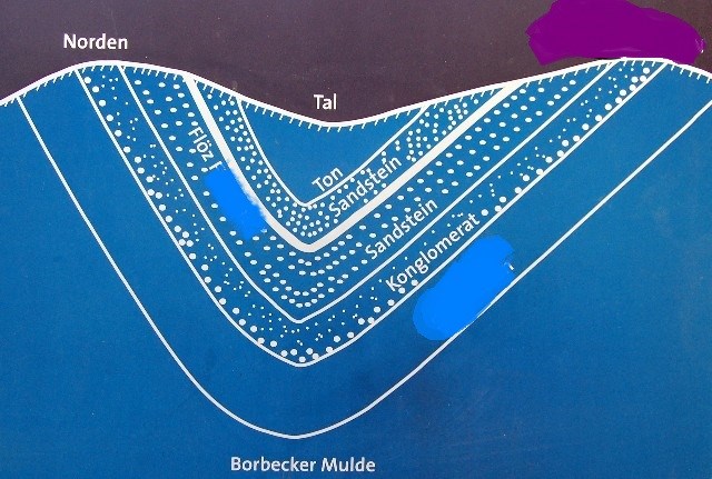
An dieser Stelle bietet sich die die seltene Gelegenheit, eine Gebirgsmulde (Borbecker Mulde) auch als ausgeprägtes Tal zu sehen.
Die unter dem Flöz liegende harte Konglomeratbank (Sandstein mit Kies) bildet die Höhenrücken.
Der weiche Tonschiefer wurde vom Wasser abgetragen, so dass östlich das Tal direkt über der geologischen Mulde liegt.
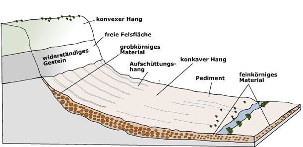 Mulden besitzen ihren Namen aufgrund ihres muldenförmigen Talquerprofils. Kennzeichnend sind sanfte Übergänge zwischen dem tiefsten Teil des Tales und den umgebenden Hängen. Bei der Entstehung von Muldentälern ist der Einfluss der Flächenspülung dominierend. Tiefenerosion fehlt hingegen weitgehend.
Um den Cache loggen zu können sind folgende Fragen zu beantworten.
- Wie heißt der Flöz der durch die Borbecker Mulde geht?
- Auf welcher Höhe befindet sich der konvexe Hang in südlicher Richtung?
- Wie heißt die untereste Schicht der Mulde?
Ein Foto von euch vor der Infotafel wäre schön. (Kein Muss)
Schicke mir deine Antworten per Mail. Loggen fertig.
Sollte was nicht stimmen melde ich mich !!!
Logs ohne Antworten werden nachträglich gelöscht.
The external image of the Ruhr area with its mountains and valleys does not always match with the layer structure.
At this point, offers the rare opportunity to see a mountain hollow (Borbecker Muldel) as a distinct valley.
The lower than the coalbed hard conglomerate rock (sandstone with gravel) forms the ridge.
The soft argillaceous shale was removed from the water, so that east of the valley lies directly on the geological hollow.
To log the cache you have to answer these questions.
- What is the name of the seam that goes by the Borbecker hollow?
- In what height located the convex slope in a southerly direction?
- What is the lowest seam of the hollow?
A photo of you in front of the information board would be nice. (Not a must)
Send the answers via our geocaching-account. Then you may log. There will be no separate log-permission, if there is something wrong, we will contact you. Please send along an e-mail-adress for fast reply, because it is time-consuming to answer the involved party! Logs without answers will be deleted later!

Additional Hints
(No hints available.)