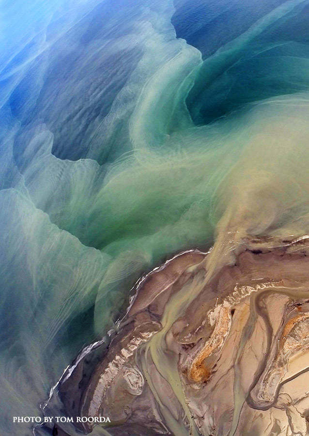
THIS IS THE MOUTH OF THE ELWHA RIVER SINCE THE DAMN HAS BEEN REMOVED.
**You may log your find immediately, however, if I do not receive your answers by the following day, your "found it" claim will be deleted.
In order to claim the Earthcache as a find, send your answers to the following questions via the message center to me, the cache owner. Note: I will contact you promptly if more information is needed.
Please do not include these answers in your online "found it" log.
1. List at least one physical difference between the North and South shorelines of the spit. Why do you suppose such a dramatic difference?
2. List at least one visible difference between the surface of the water on the North and South sides of the spit. What would you deduce is the reason for this difference? Is the color of the water affected on the day of your visit?
3. For what reason did the City of Port Angeles and the US Army Corps of Engineers enhance Ediz Hook? (see the informational sign at GZ)
4. How was the spit created and how will the removal of the Elwha River dams be beneficial to the health of the spit?
Note: The answer can be found in the story below.
Ediz Hook is a 3-mile-long (4.8 km) sand spit that extends from the northern shore of the Olympic Peninsula at Port Angeles northeasterly into the Strait of Juan de Fuca. It is a relatively narrow spit at points, but broader toward the base and the northeast tip.
The spit is accessible by car by way of Ediz Hook Road. Several parks with picnic areas are available along the way, as well as views of Port Angeles and the Olympic Mountains. A panoramic view of the peaks of Mount Angeles and Klahhane Ridge can be seen in the southwest. To the north marine traffic can be observed, as well as Orca pods, Harbor Seals, and other marine life.
"The Hook" was created by wind and tidal action that carried sediment from the Elwha River eastward. The sand spit creates a natural harbor to the south, with the spit sheltering the area of Port Angeles from the large ocean-sourced swells that roll eastward down the Strait.
The calm waters of the harbor and sandy beaches attracted people to the area long before the appearance of European explorers and settlers. Recently uncovered archeological evidence indicates that a community, known today as Tse-whit-zen, was occupied for generations by the Klallam Native American people.[1]
After settlement in the area, Ediz Hook Light was established to guide ships safely by the spit in low-visibility conditions. Currently, the end of the spit serves as a home for the Coast Guard Air Station Port Angeles.
Notable erosion of Ediz Hook has occurred in the last few decades. The cause was believed to be the presence of the Elwha River dams which reduced the amount of sediment carried by the river. The Elwha Ecosystem Restoration has since performed dam removal to restore the original flow of the Elwha River. Several projects have added large boulders to the northwest side of the spit to slow its erosion and protect the Port Angeles Harbor.

*Note: Information source Wikipedia