|
|
|
|
|
|
|
Geovallesans - pioletdefusta
|
|
|
|
|
|
Som un grup de geocatxers, alguns ens coneixem personalment, d'altres no, però tots tenim un vincle en comú: som del Vallès. Per aquest motiu, hem escollit el territori de Gallecs, per ser una gran zona verda i el pulmó del Vallès, per a fer una sèrie peculiar. Cada equip posarà un catxé, així tindrem una gran sèrie amb diferents tipus d'amagatalls, dificultats i terrenys. Esperem que us agradi!
|
|
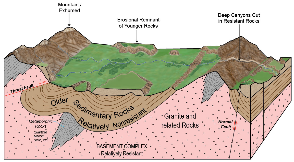
Tall geològic
Què és un tall geològic?
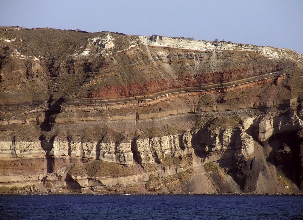
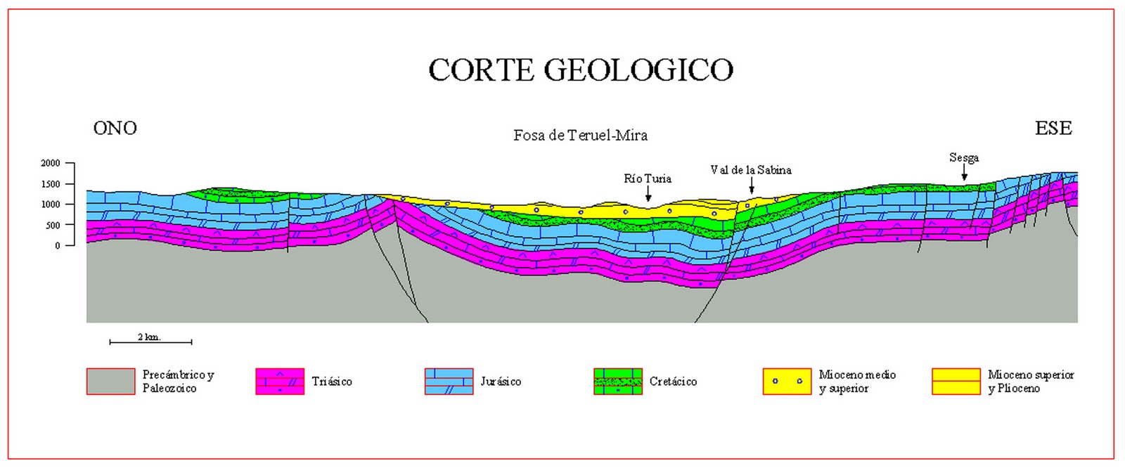
Un tall geològic és la representació d’una secció del terreny a partir de les dades obtingudes del mapa geològic, que permet veure la disposició dels materials geològics en profunditat en una zona determinada.
Un corte geológico es la representación de una sección del terreno a partir de los datos obtenidos del mapa geológico, que permite ver la disposición de los materiales geológicos en profundidad en una zona determinada.
A geological cross-section is the representation of a section of the subsurface from the data obtained from a geological map, that allows you to view the available geological materials in depth in a particular area.
Els talls geològics
Un tall geològic és una representació gràfica de la intersecció dels cossos geològics en el subsòl amb un pla vertical d'una orientació determinada. És una secció del terreny on es representen els diferents tipus de roques, llur constitució i estructura interna i les relacions geomètriques entre elles. És un model aproximatiu a la distribució real de les roques en fondària, coherent amb les informacions de superfície i de subsòl disponibles. També s'hi pot representar l'extensió dels materials i de les estructures que ja hagin estat erosionats per damunt de la superfície topogràfica.
Els talls són un complement indispensable dels mapes geològics; mapes i talls són fruit de la interpretació de la disposició de les roques a partir de diversos tipus de dades, normalment incompletes i amb diferents graus d'incertesa. Ambdós són representacions bidimensionals de la realitat geològica i conjuntament permeten comprendre l'estructura tridimensional dels volums rocosos i, en conseqüència, la història geològica d'una zona.
Els talls tenen una importància econòmica i social molt rellevant. Són la base per a planificar obres d'enginyeria, fonamentalment les obres lineals que afecten la superfície i el subsol (carreteres, túnels, canalitzacions) i per a l'exploració i la producció dels recursos geològics, hidrics, petris, minerals i energètics.
Los cortes geológicos
Un corte geológico es una representación gráfica de la intersección de los cuerpos geológicos en el subsuelo con un plano vertical de una orientación determinada. Es una sección del terreno donde se representan los diferentes tipos de rocas, su constitución y estructura interna y las relaciones geométricas entre ellas. Es un modelo aproximativo de la distribución real de las rocas en profundidad, coherente con la información disponibles sobre superficie y subsuelo. También puede representar la extensión de los materiales y de las estructuras que ya hayan sido erosionados por encima de la superficie topográfica.
Los cortes son un complemento indispensable de los mapas geológicos; mapas y cortes son fruto de la interpretación de la disposición de las rocas a partir de varios tipos de datos, normalmente incompletos y con diferentes grados de incertidumbre. Ambos son representaciones bidimensionales de la realidad geológica y conjuntamente permiten comprender la estructura tridimensional de los volúmenes rocosos y, en consecuencia, la historia geológica de una zona.
Los cortes geológicos tienen una importancia económica y social muy relevante. Son la base para planificar obras de ingeniería, fundamentalmente las obras lineales que afectan la superficie y el subsuelo (carreteras, túneles, canalizaciones) y para la exploración y la producción de los recursos geológicos hídricos, pétreos, minerales y energéticos.
The geological cross-sections
A geological cross-section is a graphic representation of the intersection of the geological bodies in the subsurface with a vertical plane of a certain orientation. It is a section of the terrain where the different types of rocks, their constitution and internal structure and the geometric relationship between them are represented. It is an approximate model of the real distribution of the rocks in depth, consistent with the information available on the surface and the subsurface. It can also represent the extension of the materials of the structures that have been eroded above the topographic surface.
The cross-sections are an indispensable complement of the geological maps; maps and cross-sections are fruit of the interpretation of the arrangement of the rocks using diverse types of data, normally incomplete and with different degrees of uncertainty. Both are bi-dimensional representations of the geological reality and jointly allow us to understand the tri-dimensional structure of the rocky volumes and, in consequence, the geological history of a zone.
The geological cross-sections have a very relevant economic and social importance. They are the basis for planning engineering works, fundamentally the lineal works thjat affect the surface and the subsurface (roads, tunnels, utilities) and for the exploration and production of geological resources: water, stones, minerals and energy.
Construcció d'un tall geològic
La construcció d'un tall geològic implica d'interpretar la disposició de les roques, tant en profunditat, com damunt de la superfície topogràfica. Consisteix a interpolar totes les dades disponibles, de superfície i de subsòl, amb l'objectiu de construir un model geològic coherent. Per aquesta raó, la construcció dels talls geològics requereix aplicar tot el coneixement de les característiques geològiques de la regió, interpretat en el marc dels coneixements teòrics del moment.
Les dades de superfície s'obtenen directament sobre el terreny (direcció i cabussament dels estrats o d'altres estructures, tipus de contactes, potència de les unitats estratigràfiques, relacions laterals esntre aquestes, etc.) o s'extreuen d'un mapa geològic efectuat prèviament (formació geològica o unitat cartogràfica, tipus de roca, angle d'intersecció amb la superfície topogràfica, dades puntuals).
Animació
Construcción de un corte geológico
La construcción de un corte geológico implica interpretar la disposición de las rocas, tanto en profundidad, como sobre la superficie topográfica. Consiste en interpolar todos los datos disponibles, de superficie y de subsuelo, con el objetivo de construir un modelo geológico coherente. Por esta razón, la construcción de los cortes geológicos requiere aplicar todo el conocimiento de las características geológicas de la región, interpretado en el marco de los conocimientos teóricos del momento.
Los datos de superficie se obtienen directamente sobre el terreno (dirección y buzamiento de los estratos o de otras estructuras, tipos de contactos, potencia de las unidades estratigráficas, relaciones laterales entre estas, etc.) o se extraen de un mapa geológico efectuado previamente (formación geológica o unidad cartográfica, tipo de roca, ángulo de intersección con la superficie topográfica, datos puntuales).
Animación
Construction of a geological cross-section
The construction of a geological cross-section involves the interpretation of the rocks arrangement, both in depth and on the topographic surface. This consists of interpolating all the available data, of surface and subsurface, with the objective of building a coherent geological model. For this reason, the construction of the geological cross-sections requires the application of all the knowledge of the geological characteristics of the region, interpreted within the framework of the theoretical knowledge of the moment.
The data on the surface are obtained directly on the field (direction and dip of the strata or other structures, types of contact, thickness of the stratigraphical units, lateral relationship between them, etc.) or they are extracted from an existing geological map (geological formation or cartographic unit, type of rock, angle of the intersection with the topographic surface, spot data).
Animation
Bibliografia:
- Institut Geològic de Catalunya (igc) i Institut Cartogràfic de Catalunya (icc), ATLES GEOLÒGIC DE CATALUNYA, març 2010
- http://www.igc.cat/web/ca/mapageol_atles_talls.html
- http://ocw.innova.uned.es/cartografia/cortes_geologicos/cog_01.htm
Validació de l'earthcache / Validación del earthcache / Earthcache validation
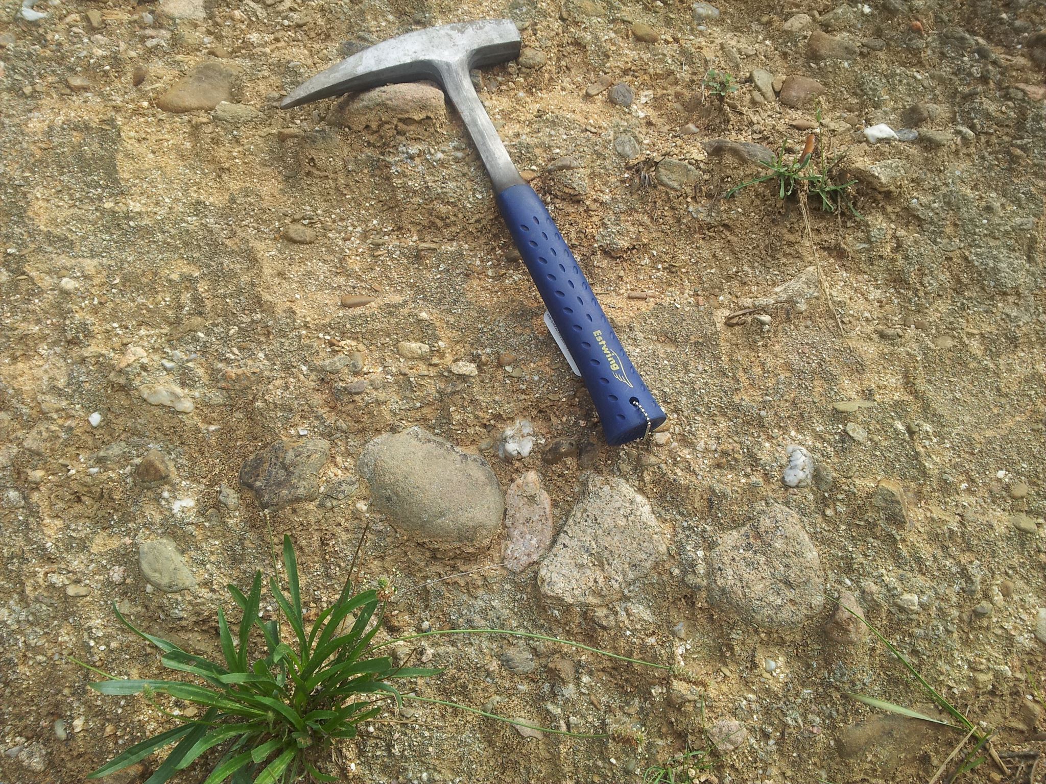
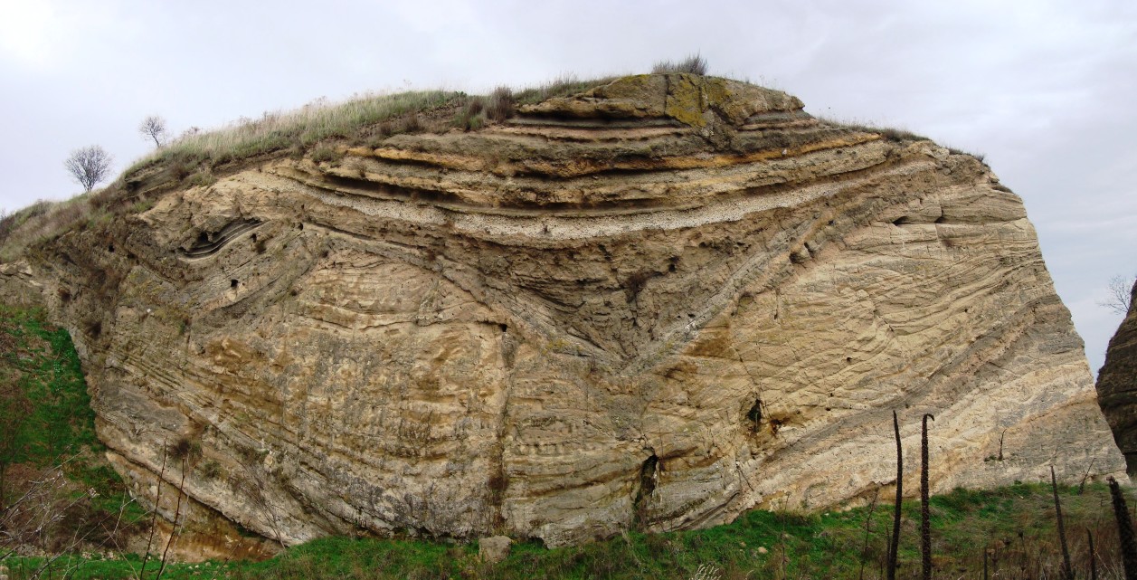
A les coordenades trobaràs un tall geològic natural de Gallecs. Respon a les preguntes següents:
1) Les roques que veus a la paret, ¿són ígnies, metamòrfiques o sedimentàries?
2) Explica en poques paraules la diferència que hi ha entre un "horst" i un "graben" ¿En quina de les dues estructures en trobem?
3) Quant mesura el mànec blau del meu martell de geòleg? (Pots mesurar les pedres del costat, ben visibles, i fer una regla de tres).
En las coordenadas encontrarás un corte geológico natural de Gallecs. Responde a las preguntas siguientes:
1) Las rocas que ves en la pared, ¿son ígneas, metamórficas o sedimentarias?
2) Explica en pocas palabras la diferencia que hay entre un "horst" y un "graben" ¿En cuál de las dos estructuras encontramos?
3) ¿Cuánto mide el mango azul de mi martillo de geólogo? (Puedes medir las piedras que tiene al lado, claramente visibles, y hacer una regla de tres).
In the coordinates you will find a natural geological cross-section of Gallecs. Answer the following questions:
1) The rocks you see on the wall, ¿are igneous, metamorphic or sedimentary?
2) A few words explain the difference between a "horst" and a "graben" ¿In what the two structures we are?
3) How long is the blue handle of my geological hammer? (You can measure the stones next to it, clearly visible, and make a rule of three).
e-mail
ignasif@gmail.com