Le Rocher de Roquebrune. EarthCache
-
Difficulty:
-

-
Terrain:
-

Size:  (other)
Please note Use of geocaching.com services is subject to the terms and conditions
in our disclaimer.
 Français.
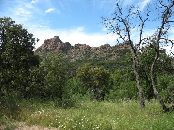
Le Rocher de Roquebrune, qui ne fait pas partie d'un ensemble montagneux, se dresse seul au milieu de la plaine de l'Argens.
Il est classé site d'intéret national.
Il sépare les Maures de l'Estérel.
De quoi est-il formé ?
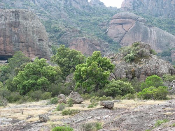
C'est un poudingue, c'est-à-dire un conglomérat de blocs, de galets et de fer emprisonnés dans un ciment silicieux très dur.
Il est majoritairement constitué de roches exogènes détritiques. Celles-ci proviennent de l'accumulation de fragments de minéraux et de roches préexistantes continentales, formées à la surface de l'écorce terrestres comme le grès, le sable, le limon, l'argile...
Comment s'est-il formé ?
Son histoire débute à l'ère primaire.
Il y a 400 millions d'années, il n'y a que la mer.
Au fond de celle-ci, se creuse une dépression où se déposent au cours des millénaires des épaisseurs considérables de sédiments.
Lors de mouvements tectoniques, il y a 300 millions d'années, des pressions considérables sont exercées sur cette fosse.
Le plissement des sédiments forme alors une très haute chaine de montagne.
C'est au Permiens, il y a 280 millions d'années, que la chaine de montagne est arasée, se transformant en plateau.
Puis, sous l'effet de violentes pressions, ce massif se fracture, formant des failles parallèles, par où va
remonter du magma, qui comble les reliefs.
La falaise qui surplombe le socle métamorphique et granitique (formé par le magma) subit de violentes
érosions.
Des débris rocheux arrachés de la paroi s'accumulent pour former un gigantesque cône de déjection composé de blocs de granit, de gneiss et d'embrechites, ainsi que d'éclats de pyroméride.
On y trouve aussi du sable et des galets de rhyolite.
De l'une des failles jaillissent des eaux chaudes très riches en silice qui s'infiltrent au coeur des sédiments
formant finalement la roche très dure caractérisant le Rocher.
L'affaissement du massif des Maures dégage le Rocher de Roquebrune.
L'érosion lui donne au fur et à mesure son aspect définitif.
Pour valider cette cache, vous devez répondre à 3 questions et m'envoyer les réponses par mail.
Une photo de vous ou de votre gps à l'endroit de la Earth cache serait appréciée, mais reste optionnelle.
Question 1 : Quelle est la couleur dominante de la roche à l'endroit où vous vous trouvez ?
Question 2 : Quel élément lui donne cette couleur ?
Question 3 : Versez un petit peu d'eau sur de la roche, près de là où vous êtes. La roche est-elle perméable ou imperméable? (une roche est perméable lorsqu'elle laisse pénétrer l'eau, imperméable quand l'eau ruisselle dessus sans s'infiltrer)
Un très grand merci à Elia's pour tout ses conseils.

English.
The Rocher de Roquebrune, which is not part of a mountain range, stands alone in the middle of the plain of Argens.
It is classified a site of national interest.
It separates the Maure of Esterel.
What is it formed?
It is a poudingue, that is to say a conglomerate of boulders, iron and pebbles trapped in a siliceous cement very hard .
It consists mostly of detrital rocks exogenous. They come from the accumulation of Minerals fragments and continental pre-existing rocks, formed on the surface of the earth's crust as sandstone, sand, silt, clay ...
How was it formed? :
His story begins in the primary era.
There are 400 million years there is only the sea.
At the bottom of it, is widdening a depression which are deposited during thousands of years considerable thickness of sediment.
During tectonic movements, there is 300 million years, considerable pressure is put on the marine trentch.
The folding of the sediments then forms a high mountain chain.
At the Permians, there is 280 million years, the mountain range is leveled, turning into plateau.
Then, under the influence of violent pressure this massif fractures, forming parallel faults, allowing passage for the magma, who fills up the reliefs.
The cliff overlooking the metamorphic and granitic basement (formed by magma) is subject to severe erosion.
Torn off the wall rock debris accumulate to form a giant alluvial cone composed of blocks of granite, gneiss, embrechites and splinters of pyroméride.
There are also sand and pebbles of rhyolite.
In one of the flaws shoot up hot water with lot of silica, infiltrating the heart of the sediment, eventually forming the very hard rock characterizing the Rocher de Roquebrune.
The collapse of the Massif des Maures release the Rocher de Roquebrune.
Erosion gives to him his final appearance.
Questions / conditions:
To valide this cache, you must answer corectly at this 3 questions :
Question 1: What is the dominant color of the rock where you are ?
Question 2: What element gives it this color ?
Question 3: Pour a little water on a rock near your position. Is the rock permeable or impermeable? (a rock is permeable when the water is able to creep in, imperméble when water runs over without infiltrate)
A picture of you at the spot will be appreciate, but is optional.
Please send your replies to my account.
Additional Hints
(No hints available.)