No, this has nothing to do with our poorly maintained roads!
Only attempt this cache at low tide and with slight seas. Not only will you risk life and limb if the waters are high or washing over the rocks, you won't be able to see what you're looking for.
Some of the rocks around the headland can be very slippery. Treat any wet rock as slippery until you can feel that it's not. I recommend bare feet or shoes with good grip, not thongs!
Potholes, also known as caldrons, cisterns, ephemeral pools, tanks, tinajas, waterpockets and weathering pits, are holes eroded away in otherwise relatively flat bedrock. They can be found in a wide variety of environments, including tidal coastline, river beds, deserts and tundra. Depending on the environment, they may be formed by one or more different mechanisms.
Direct mechanical erosion occurs when pebbles and grit are caught in eddy currents produced by water moving over the pothole, enlarging the hole from within. For this to occur, the eroding agent must have a hardness greater than or equal to the bedrock, hence such potholes are more commonly found in softer rocks such as sandstone.
Alternatively, biological weathering can be the dominant agent, whereby cyanobacteria, algae and fungi form a biofilm which breaks down the siliceous minerals in the pothole for nutrients, resulting in further weathering. Organisms on and within the rock form a “weathering front” in which water is retained and the pothole enlarged through a combination of biological and physical means.
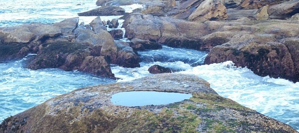
At the listed coordinates, on the end of the rock shelf at the base of the headland, you'll see several large potholes about a metre across, each containing a semi-isolated aquatic ecosystem. Lying between the high water and low water marks, these holes are permanently filled with seawater, with waves breaking over them depending on the tide and seas. Here's a picture of one so you know what you're looking for:
Question 1: How many of these large potholes can you see in the immediate vicinity?
Question 2: Is the interior diameter of the hole biggest at the top, middle or bottom? Why might that be?
Eventually, over time, the wall of the pothole will erode through, opening the hole to the sea and draining it at low water.
Question 3: Can you see the remains of any such eroded-through holes? (Include a photo or provide a description of it in relation to the other potholes).
If it is safe to do so (remember, only come here at low tide and with slight seas), get as close to one of the holes as you can.
Question 4 (optional): Describe what you can see at the bottom of the hole. Does this give any clue as to how they were formed?
You may email you answers to geocaching@barefoottimes.net, or send a message via my profile page. Feel free to attach any photos you have to corroborate your answers, but they aren't a requirement for logging. I'll try to respond to your answers as soon as I can but there's no need to wait for that before logging your find.
Enjoy your visit and take your time on the way back to check out some of the other rock formations on the headland.
Footnote: When I set this cache, the water in the potholes was crystal clear, but it appears to go cloudy at times. If this is the case and you have trouble answering some of the questions, just make a note of it in your answers.
Tide times can be found at http://www.bom.gov.au/australia/tides/#!/nsw-patonga and forecast sea conditions are at http://www.bom.gov.au/nsw/forecasts/huntercoast.shtml.