L'
Earthcache
Dans le texte ci-dessous ainsi que sur le panneau d'information du site des coordonnées, vous allez obtenir les informations nécessaires pour répondre aux questions suivantes. Celles-ci doivent m'être renvoyées par courriel afin de procéder à votre enregistrement comme trouvée. Sinon, se traduira par sa suppression sans préavis. Vous n'avez pas besoin d'attendre la permission pour faire votre enregistrement. Si il ya un problème, vous serez contacté pour le résoudre.
- Dans les Alpes Mancelles, qu'est-ce qui frappe l’imagination, comme le feraient autant de pics élevés?
- Quels sont les processus géologiques qui ont contribué à créer ce paysage d'aujourd'hui?
- Qui est le témoin des dernières glaciations dans le Perrier du "Grand Patis"?

The Earthcache
In the text below, as well in the place pointed by the coordinates, one can find the necessary information to answer the following questions. These should be sent to my email in order to make a found log. Failing to do this will result in the deletion of your log without notice. You don't need to wait for permission to log. If there is a problem you will be contacted to resolve it.
- What strikes the imagination, as would many lofty peaks, in the Mancelles Alps?
- What are the geological processes that helped create the today’s local landscape?
- What is witnessed in the "Grand Patis" scree?
Les Alpes Mancelles
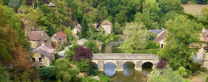
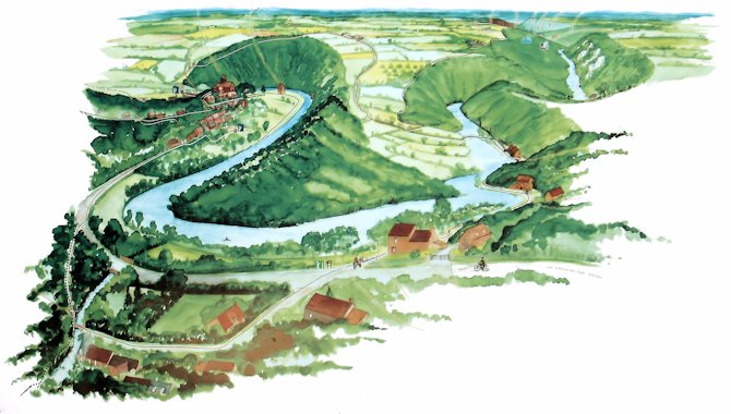
Situées à la limite du Maine et de la Normandie, les Alpes Mancelles constituent une région naturelle des départements de la Sarthe, de la Mayenne et de l'Orne, appartenant au massif armoricain. Elles se caractérisent par leurs vallées encaissées où coulent la Sarthe et certains de ses affluents.
Les Alpes Mancelles prétendent au titre de "montagnes les plus proches de Paris". Bien sûr, ces Alpes vues de haut n’ont rien de montagnes. Mais, du fond des vallées, la raideur des pentes, l’ampleur des dénivelés, les crêtes et les pierriers, frappent l’imagination comme le feraient autant de cimes altières.
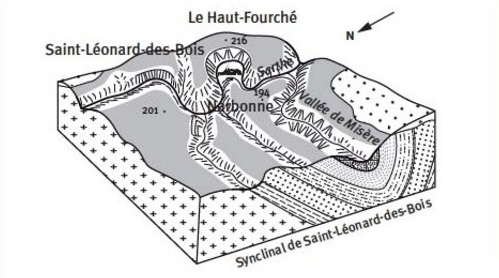
La variété des paysages résulte d’une histoire géologique complexe, marquée par des phases successives de plissements et d’érosion.
Plis
Un pli géologique se produit lorsque l'un ou un empilement de surfaces plates et initialement planes, telles que des couches sédimentaires, sont coudées ou courbées à la suite d'une déformation permanente.
Érosion
L'érosion est le processus par lequel le sol et la roche sont retirés de la surface de la Terre par des processus exogènes telles que le vent ou l'eau couler, puis transportés et déposés dans d'autres endroits.
La légende
D’après une légende locale, le nom d’Alpes Mancelles aurait été donné au VIIème siècle par deux frères, originaires de Spolète en Ombrie, Céneri (de son vrai nom Serenicus ou Genericus) et Cerenède, qui, ayant quitté Rome pour le royaume des Francs et franchi les Alpes, décidèrent de n’arrêter leur marche qu’en présence d’un paysage leur évoquant des sites alpestres; ce qu’ils firent dans cette partie escarpée de l’actuel département de la Sarthe.
Les deux frères devinrent ermites, un monastère fut construit après leur mort sur l’actuelle commune de Saint-Céneri-le-Gérei mais il fut détruit par les Normands au début du Xème siècle.
The Mancelles Alps
Situated at the limit of Maine and Normandy, the Mancelles Alps are a natural region of the of Sarthe, the Mayenne and Orne departments, belonging to the Armorican Massif. Crossed by the Sarthe, they are characterized by deep valleys where the Sarthe and some of its tributaries flow.
The Mancelles Alps claim the title of "the mountains closest to Paris". Of course, these Alps viewed from a high point do not resemble any mountain. However, the valleys, the steep slopes, the magnitude of elevations, ridges and scree, strike the imagination as would many lofty peaks.
The variety of landscapes resulted from a complex geological history, marked by the successive phases of folding and erosion.
Fold
A geological fold occurs when one or a stack of originally flat and planar surfaces, such as sedimentary strata, are bent or curved as a result of permanent deformation.
Erosion
Erosion is the process by which soil and rock are removed from the Earth's surface by exogenous processes such as wind or water flow, and then transported and deposited in other locations.
The Legend
According to a local legend, the name of Mancelles Alps was given in the seventh century by two brothers from Spoleto in Umbria, Céneri (real name of Serenicus or Genericus) and Cerenède, who had left Rome to the Kingdom of the Franks and crossed the Alps, decided to stop their journey in the presence of a landscape evoking their alpine locations, which they did in this steep the current Sarthe part.
The two brothers became hermits, and a monastery was built after their death on the current commune of Saint-Céneri-the-Gérei but it was destroyed by the Normans in the early tenth century.