15km North West of Mackay there are a number of significant topographic features that dominate the surrounding landscape. They are quite visible from the Bruce Highway when heading north or south, and on closer inspection, they can also provide insights into the volcanic origins of this area. Rising to some 550m, with its flat top and steep sides of exposed granite, Mount Jukes is pretty obvious.
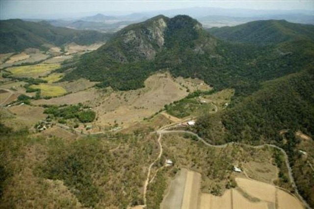
But what really enforces the peak’s apparent volcanic origins, is the surrounding valley. The valley arcs around the central peak of Mount Jukes, with a sharp and distinct apparent rim. The valley, cleared for cane farming and grazing, combined with the sheerness of Mount Jukes, adds to the appearance that it is the remnants of a large volcanic crater, with the central peak a large volcanic plug. This is very apparent when viewing the area in aerial or remote sensed imagery … like the imagery available in Google earth, or by turning the Satellite / imagery layer on, in the Geocaching Map page (found in top right hand corner).
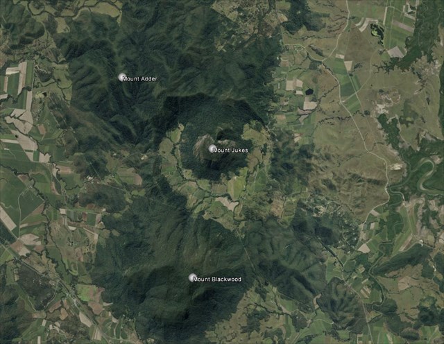
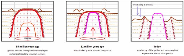
Well it may look like an ancient massive volcano … but what we actually have here, is a more recent plutonic intrusion within a much older intrusion. The granite dome of Mount Jukes occupies the central part of the Neilson leucogabbro, a much older circular intrusion occurring approximately some 55 million years ago.
Gabbro refers to a large group of common, dark, course grained, mafic (high levels of heavier elements), intrusive igneous rocks. The prefix ‘lueco’ is derived from the Greek word leukos, meaning white or lacking colour, and is used in geology to describe rocks that are much lighter in colour than the normal or average. So leucogabbro differs from gabbro, in that whilst it has similar composition and origins, it is much lighter in colour to most forms of gabbro, due to increased amounts of felsic minerals (like plagioclase). This gabbro intrusion pushed up through the surrounding older Permian sedimentary layers of the Carmila beds (a series of sandstones and shales), creating a narrow hornfels aureole, a ring of hardened metamorphosed rocks around the intrusion’s contact perimeter. Subsequent weathering and erosion has left the hard steep ridges evident to the east and west of Mount Jukes today, with the narrow ridges delineating the extent of the original gabbro intrusion.
The peaks in the Mount Jukes Complex (Mount Jukes and Mount Blackwood) were produced by subsequent plutonic intrusions, pushing up through the then existing sedimentary and intrusive formations, some 32 million years ago, 20 million years after the leucogabbro intrusion. Mount Blackwood (to the south with the repeater on top) is a massive irregular intrusion of quartz syenite, which has intruded through the southern part of the leucogabbro. Syenite is similar to granite, but usually higher levels of alkali feldspar (orthoclase) and lacking quartz in its composition. Quartz syenite therefore seems like an oxymoron, but although the descriptor is used, it still has very low levels of quartz present, it just has more than regular syenite.
Studies of the formations, and analysis of the composition of the subsequent tertiary intrusions associated with the more recent activity, indicates that the Mount Jukes intrusion (granophyric granite), and those to the north (Seaforth microgranite) and south (Mount Blackwood quartz syenite), may have actually occurred at different times. Mount Jukes itself, is thought most likely to be, the most recent intrusion in the complex. Mount Jukes is classified as a ‘boss’ shaped intrusion. The characteristics of a ‘boss’ intrusion are: a small (<100sqkm) roughly circular igneous (or plutonic) intrusive structure. The presence of brecciated rock along contacts and concentric dykes, radiating out from the intrusion, suggest that the granite of Mount Jukes was forcibly pushed through the Neilson leucogabbro.
The current features dominating and surrounding the valley, are as a result of the different age and composition of the rocks, subsequent geological activity, and persistent weathering of the original intrusion material, and the various formation’s (intrusion’s) resistance to weathering … leaving us with the landscape we can see today.
As Mount Jukes itself is inaccessible (no public access), to claim a find on this earthcache, you will need to take a drive through the valley, stopping at the listed waypoints, and send me your answers to the following questions and tasks. (Please include the name and code of the cache on the first line).
1. Estimate the size of the Mount Jukes ‘boss’ intrusion, and approximate the diameter of the Neilson leucogabbro, which the boss structure of Mount Jukes has intruded. By the definition, are both intrusions 'boss's?
2. Visit the following waypoints and briefly note and comment on the geology present / observed:
Only a quick drive by is required at Waypoints 1 & 2, but a closer inspection is required at Waypoint 3.
Waypoint 1: S 21 00.236 E 148 56.327
– what is in the creek bed?
Waypoint 2: S 21 00.002 E 148 55.818
– is layering evident?, what other geological structures are present?
Waypoint 3: S 21 00.372 E 148 55.941
(parking and turning available just up the road at S 21 00.414 E 148 55.987)
– what colour is the rock?, are layers still observable?,
… think about the geology observed at the waypoints visited, and …
3. describe briefly how the 3 sites visited fit into confirming the presence of the original intrusion.
As you look across the valley, what can you determine about the geology here, compared to the gabbro.
And finally …
4. At Waypoint 3 there is also another geological feature present in the exposed rock face. What do you think it is? Describe it and approximate its width. Examine the apparent strike and contact between the rock types. Which major intrusion do you think it is associated with?
And for a bonus (but not required) …
Can you spot the other geological feature within this feature and approximate its width.
References
P.J. Stephenson, Geological Society of Australia, Field Conference Notes 1985
Commonwealth of Australia, Geological Reports and Geological Map Notes 1966, 1968
Queensland Government, National Parks Management Plan, DERM 2011