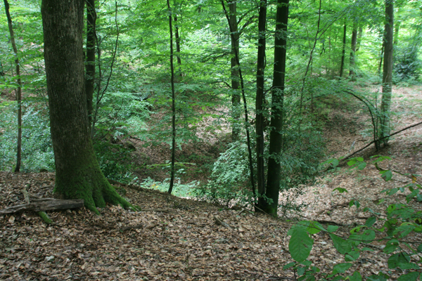
La fosse Martin Godard
Un phénomène de la nature
A. Devos, O. Lejeune
EA 3795 G.E.G.E.N.A. (Groupe d’Etude sur les Géomatériaux et les Environnements Naturels et Anthropiques), UFR Lettres et Sciences Humaines, 57 rue Pierre Taittinger, 51096 Reims Cedex,
alain.devos@univ-reims.fr , et olivier.lejeune3@libertysurf.fr
La craie champenoise est considérée comme une roche d’une grande homogénéité. Ceci implique des transmissivités généralement comprise entre 10-3 à 10-1 m2/s. Pourtant les pollutions ponctuelles semblent apparaître ponctuellement mais très rapidement dans les captages d’eau potable de la ville de Reims situés dans le bassin-versant de la Vesle ; laissant penser à des arrivées d’eau ayant de fortes vitesses de transit.
Afin d’expliquer la présence ponctuelle de ces polluants, les membres du G.E.G.E.N.A. ont été mandatés depuis 2004, afin d’étudier les modalités d’infiltration et de restitution des eaux dans le bassin-versant de la Vesle et en Montagne de Reims.
Ainsi, ce rapport, réalisé le cadre du programme AQUAL et PIREN-Seine, doit faire le bilan des dernière années de recherches sur le modalités d’infiltration et de circulation des eaux dans la zone vadose. Nous ferons aussi le point sur les modalités de restitution de eaux via la zone noyée. Nous établirons aussi un bilan de l’année 2006, sur les dernières avancées sur la connaissance de la géométrie des formations superficielles sur les versants et les formations du fond de la vallée de la Vesle.
1. Modalités d’infiltrations en zone crayeuse
Les caractéristiques hydrodynamiques de la craie campanienne lui confèrent en général une modélisation de ses écoulements relativement simple à un, voire à deux réservoirs. Les 20 à 30 m de la partie supérieure de la craie proche de la surface constituent une zone à forte détente mécanique correspondant à un réservoir à porosité efficace et à forte productivité. A l’ouest du bassin Vesle, elle a connu plusieurs épisodes régressifs et transgressifs à l‘Eocène (Thanétien) qui lui donnent une surface irrégulière (dénivelée inférieure à 5 m) et fissurée à blocs de marnes durcies. Durant le Pléistocène, de nombreux cycles cryoclastiques ont produits des grèzes remaniées par la déflation éolienne (graveluches) propices à l’infiltration rapide et bien représentées dans l’est du bassin (Laurain et al., 1995).
A l’inverse, en profondeur, la craie peu fissurée détermine un autre réservoir à faible productivité (micro-porosité) dont la porosité efficace dépend directement du degré de fissuration. Sans fissures, les caractéristiques intrinsèques des craies du bassin de la Vesle déterminent une forte porosité totale (43%) qui cache une porosité efficace très faible comprise entre 2% et 6% (mesurées en laboratoire et sur le terrain). Les vitesses d’infiltration potentielles sont alors très faibles, de l’ordre de 0,5 m/an (Barbin V. et al., 1993) ce qui pose un sérieux problème de résilience de l’aquifère. La transmissivité est généralement comprise entre 10-3 à 10-1 m2/s et le coefficient d’emmagasinement est compris entre 1 et 5%.
Les modalités d’infiltration sont donc largement inféodées à la fissuration de la craie qui détermine le type de porosité et les écoulements souterrains préférentiels.
Les linéaments observés sur le terrain, sur les cartes et les photographies aériennes témoignent d’orientations préférentielles NNW (320 à 330°) et NNE (25 à 35°) qui ont manifestement calé l’installation du réseau de talweg (Laurain, 1980, Laurain et al., 1981). Moins de 25% de ce réseau est drainé par un cours d’eau intermittent ou pérenne, ce qui souligne d’une part l’héritage pléistocène de ces formes d’incision et d’autre part l’importance de l’infiltration généralisée dans le bassin.
Les vallées et les vallons affluents sont donc en général des secteurs à forte productivité et à plus grande perméabilité à la différence des interfluves.
A la différence des craies de Normandie et de Picardie, les craies de Champagne sont affleurantes ou subaffleurantes et dénuées de formations superficielles favorables au ruissellement. L’infiltration généralisée prédomine, déterminant ainsi une large part aux débits de base souterrains qui constituent plus de 80% des écoulements des cours d’eau indigènes à la craie.
A. Modalités d’infiltration et front de karstification
Durant ces trois années, un front de karstification a été mis en évidence sur le flanc nord de la Montagne de Reims sur le front de la cuesta d’Ile de France correspondant au versant sud du bassin Vesle à l’aval de Sept-Saulx (figure 1).
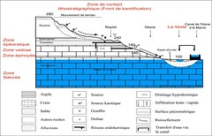
Figure 1 : Schéma fonctionnel du karst du bassin-versant de la Vesle
Un karst de contact lithostratigraphique perché dans l’Eocène.
C’est sur les replats structuraux des sables grésifiés du Thanétien que la karstification s’opère car ils correspondent à un contact lithostratigraphique majeur à perméabilités contrastées. Ils constituent une zone d’infiltration des eaux ruisselantes sur les formations imperméables de l’Eocène au contact des roches perméables (grès et craie) vers 220 m d’altitude soit 60 m au-dessus de la surface piézométrique de la nappe de la craie.
Le liséré exokarstique est représenté par des dolines métriques et décamétriques en cuvette et en entonnoir, des gouffres et de rares vallées aveugles aux pieds d’un versant réglé développé dans les formations éocènes argileuses favorables aux ruissellements concentrés. Ces derniers s’organisent dans des ravins qui ont pour exutoire les dolines ou des gouffres formant ainsi des vallons aveugles.
Un karst étagé.
On observe deux niveaux de karstification : d’une part au niveau du contact litho-stratigraphique de l’Eocène et d’autre part dans la craie sous-jacente.
Le premier a pour vocation de recueillir et de concentrer les écoulements de surface par des collecteurs horizontaux alors que le second est un karst d’infiltration verticale et concentrée.
Les réseaux endokarstiques dentritiques ou méandriformes à collecteur unique (Fontaine Pleureuse, Creusin) se développent horizontalement sur plusieurs centaines de mètres dans les grès thanétiens. Les collecteurs pénétrables recrutent des affluents à accès difficile mais l’ensemble correspondre à des galeries ovoïdes de petite taille (1,5 m de diamètre) localement retouchés par l’homme. Ces collecteurs concentrent les écoulements vers des puits et gouffres de la craie tout en drainant l’aquifère perché des sables grésifiés.
De rares collecteurs reconnus spéléologiquement affectent la craie (systèmes de Trépail sur le versant Marne et de la Fontaine de Verzy sur le versant Vesle). Leur accès difficile (AEP, effondrement) limite considérablement leur connaissance.
Les descriptions faites par les spéléologues ainsi que les premières reconnaissances effectuées par nos soins témoignent de galeries méandriformes, callées sur fractures, de belle facture (hauteur atteignant 20 m de hauteur) avec des développements importants pour le secteur (plus de 500 m pour le système de Trépail et 540 m pour la Grande Fontaine). Le déficit en endokarst crayeux constaté s’expliquerait davantage par le manque d’information et la faible anthropisation du plateau forestier. Les deux grands systèmes karstiques sont explorés qu’après des travaux importants ou des effondrements de voûtes (Rodet J., 1991). le G.E.G.E.N.A. mène des travaux de recherche (en cours) sur le collecteur que depuis octobre 2006 en collaboration avec le conseil Municipal de Trépail.
Un karst couvert.
Le karst de la craie qui présente les plus gros conduits est sous couverture de type cap-rock sablo-gréseux (gouffres-aveugles). Celle-ci peut s’effondrer brutalement sous son propre poids trépanant ainsi le toit voire le plancher des collecteurs des sables grésifiés (Creusin) ouvrant béant des gouffres en surface et laissant apparaître toutes les formations concernées (craie, sables et argiles sus-jacentes) comme à la Fosse martin Godard. Ce phénomène illustre l’importance de la macro-porosité efficace de type karstique au niveau du front de karstification dans le bassin Vesle.
Pour valider votre log, merci de répondre aux questions suivantes sur mon profil :
Quel est le nombre des principaux karsts sous couverture ?
Quel est le type de karst rencontré en Champagne ?
Avec quoi est en relation la Fosse Martin Godard ?
Joindre une photo de la Fosse et si vous le souhaitez, de vous.
English version
A. Devos, O Lejeune
EA 3795 G.E.G.E.N.A. ¶(Group of Study on the Natural Géomatériaux and Environments and Anthropiques), UFR Letters and Social sciences, 57 street Pierre Taittinger, 51096 Reims Cedex,
The chalk Champagne is regarded as a rock of a great homogeneity. ¶This implies transmissivities generally ranging between 10 -3 to 10 -1 m 2 / S. Pourtant specific pollution seem to appear punctually but very quickly in drinking water collectings of the town of Reims located in the basin-slope of Vesle; ¶letting think on water arrivals having strong speeds of transit.
In order to explain the specific presence of these pollutants, the members of the G.E.G.E.N.A. were elected since 2004, in order to study the methods of infiltration and restitution of water in the basin-slope of Vesle and in Mountain of Reims.
Thus, this report/ratio, carried out the framework of program AQUAL and the PIREN-Seine, must take stock of last the years of research on the methods of infiltration and circulation of water in the zone vadose.¶We will give also a progress report on the methods of water restitution via the drowned zone. ¶We will establish also an assessment of the year 2006, on the last projections on the knowledge of the geometry of the surface formations on the slopes and the formations of the bottom of the valley of Vesle.
1.¶Methods of infiltrations in chalky zone.
The hydrodynamic characteristics of the chalk campanienne in general confer to him a modeling of its flows relatively simple to one, even with two tanks.¶The 20 to 30 m of the higher part of chalk close to surface constitute a zone with strong mechanical relaxation corresponding to a reserve with effective porosity and strong productivity.¶In the west of the Vesle basin, she knew several regressive and transgressive episodes with l`Eocene (Thanétien) which give him a surface irregular (uneven lower than 5 m) and fissured with blocks of hardened marls.¶During Pleistocene, many cycles cryoclastic produced grèzes altered by wind deflation (graveluches) favourable with the fast infiltration and represented well in the east of basin (Laurain et al..>.>, 1995).
Conversely, in-depth, the chalk little fissured determines another reserve with low productivity (microporosity) whose effective porosity depends directly on the degree of cracking.¶.>Without cracks, the intrinsic characteristics of chalks of the basin of Vesle determine a strong total porosity (43%) which hiding place a very low effective porosity ranging between 2% and 6% (measured in laboratory and on the ground).¶.>Potential speeds of infiltration are then very low, about 0,5 m/an (Barbin V et al..>.>, 1993) what poses a serious problem of impact strength of the aquifer.¶.>The transmissivity generally lies between 10 -3 to 10 -1 m 2 / S and the coefficient of storage lies between 1 and 5%.
¶The methods of infiltration are thus largely pledged with the cracking of the chalk which determines the type of porosity and the underground flows preferential.
¶The features observed on the ground, the charts and the photographs air testify to preferential orientations NNW (320 to 330) and NNE (25 to 35) which obviously fixed the installation of the network of thalweg (Laurain, 1980, Laurain et al..>.>, 1981).¶.>Less than 25% of this network is drained by a river intermittent or perennial, which underlines on the one hand the heritage pleistocene of these shapes of incision and on the other hand the importance of the infiltration generalized in the basin.
The tributary valleys and small valleys are thus in general sectors with strong productivity and greater permeability to the difference of the interfluves.
With the difference of chalks of Normandy and Picardy, the Champagne chalks are levelling or subaffleurantes and stripped of surface formations favorable to the streaming.¶The generalized infiltration prevails, thus determining a big part with the underground basic flow which constitutes more than 80% of the flows of the indigenous rivers to chalk.
A. Methods of infiltration and face of karstification.
During these three years, a face of karstification was highlighted on the northern side of the Mountain of Rheims on the face of the cuesta of Island of France corresponding to the southern slope of the Vesle basin to the downstream of Sept-Saulx (figure 1).
A karst of lithostratigraphic contact perched in the Eocene.
It is on the structural projecting ledges of grésifiés sands of Thanétien that the karstification takes place because they correspond to a major lithostratigraphic contact with contrasted permeabilities.¶They constitute a zone of infiltration of water streaming on the impermeable formations of the Eocene in contact with the permeable rocks (sandstone and chalk) around 220 m of altitude is 60 m above the piezometric surface of the tablecloth of chalk.
¶The bordered exokarstique one is represented by dolines metric and decametric out of basin and funnel, pits and rare valleys plug with the feet of a regulated slope developed in the argillaceous Eocene formations favorable to the concentrated streamings.¶The latter are organized in ravines which have for discharge system dolines or of the pits thus forming blind small valleys.
A staged karst.
One observes two levels of karstification:¶on the one hand on the level of the lithostratigraphic contact of the Eocene and on the other hand in chalk subjacent.
¶First A for vocation to collect and concentrate the flows of surface by horizontal collectors whereas the second is a karst of vertical and concentrated infiltration.
¶The networks endokarstic dentritic or méandriformes with single collector (Whining Fountain, Creusin) develop horizontally on several hundred meters in the sandstones thanétiens.¶The penetrable collectors recruit affluents with difficult access but the unit to correspond to ovoid galleries of small size (1,5 m diameter) locally improved by the man.¶These collectors concentrate the flows towards wells and pits of chalk while draining the aquifer perched of grésifiés sands.
¶Rare collectors recognized spéléologiquement affect the chalk (systems of Trépail on the Marne slope and of the Fountain of Verzy on the Vesle slope).¶Their difficult access (AEP, collapse) limit considerably their knowledge.
¶The descriptions made by the speleologists as well as the first recognitions carried out by our care testify to galleries méandriformes, callées on fractures, of beautiful invoice (height reaching 
20 m height) with significant developments for the sector (more than 500 m for the system of Trépail and 540 m for the Large Fountain).¶The deficit in chalky endokarst noted would be explained more by the lack of information and the weak anthropisation of the forest plate.¶The two great karstic systems are explored that afterwards significant work or collapses of vaults (Rodet J, 1991).¶the G.E.G.E.N.A. undertakes research tasks (in progress) on the collector that since October 2006 in collaboration with the town council of Trépail.
A covered karst.
The karst of the chalk which presents largest conduits is under cover of sablo-sandy the cap rock type (pit-blind men).¶This one can break down brutally under its own weight thus trépanant the roof even the floor of the collectors of grésifiés sands (Creusin) opening open pits on the surface and letting appear all the formations concerned (chalk, sands and overlying clays) as with the Pit Martin Godard.¶This phenomenon illustrates the importance of the effective macroporosity of karstic type on the level of the face of karstification in the Vesle basin.
To validate your log, thank you to answer the following questions to my profil :
Which is the number of principal the karsts under cover?
Which is the type of karst met out of Champagne?
With what in relation the Pit Martin Godard is?
To join a photograph of the Pit and if you wish it, of you.