Attention:
You have not to wait for our permission but send the answer e-mail immediately together with the log! No logs like: "Will send the answers later, when back home, when having better internet", etc. Such kind of logs we will delete without prior notification.

The "Ladies Cave" at the beach of Saundersfoot
Pembrokeshire is the most south-westerly Welsh county and with over 270 km of coastline, it has a wide variety of geological features. If you enter this area, please be careful with nature.
For accessing the Ladies Cave no special permission is needed, but is open to the public as a part of the southern beach of Saundersfoot. However, it is only accessible on foot at low tide. At these times it's rest and relaxation area for many people. Hence the name of the cave: ladies are searching for shelter from the rain. Please inform yourself about the tides at relevant websites such as Timetable . Most web pages are related to the disclosures of Milford Haven, Wales. For your own safety you should assume that the flood will reach its highest level here about 30 min. earlier than indicated for Milford Haven.
So if you stay there too long and the water level begins to rise, the way back through the port may not be possible. In this case you'll have to use the stairs at the coordinates of waypoint 4 as an "emergency exit". It is located in approximately half the distance to the port and you can save some time. Please note: In full flood it is also not accessible.
At this site you have an excellent opportunity to explore the processes of folding of the rock layers.
Earthcache Lesson 1:
The rock consists of sandstone and mudstone; therefore one can conclude that the area was located in an estuary before the folding began. The entrained mineral and rock pieces encamped there in layers. If the grain size from 0.002 to 0.079 inches and the fraction of these at least 50%, it is referred to as sandstone. The solidification took place by cementation. In the process loose sand and finer or coarser sediment particles such as clay, silt and cobbles are cemented together. This is accomplished by the precipitation of minerals in the voids between the sand grains. This precipitation stops when the proportion of fine grained clay increases. Then the permeability is reduced and thus with formation, water cannot penetrated. Now it is referred to as mudstone. Here both processes are easy to recognize clearly demarcated layers.
Earthcache Lesson 2:
A fold is the bending or curvature of one or more geological boundaries such as the layering of sedimentary rocks described above.
During the folding are visible changes of the course of the rock layers. The folding originated in the geological process through extreme lateral forces on the rock strata.
The Ladies Cave was formed about 290-300 million years ago at the end of the Carboniferous period by the collision of continental plates. Here the profiles of the individual layers of rock and the nature of the geological form are, even for laymen, not hard to see and very easy to discover.
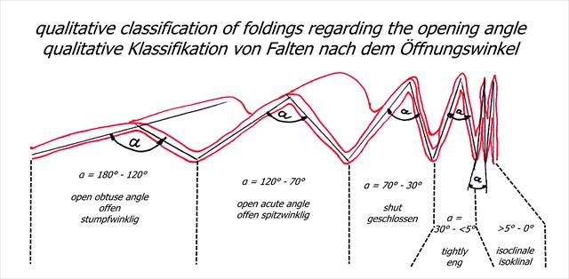
Folds may come in various sizes, positions and shapes. Geologically they are classified among others according to the opening angle. See the following drawing:
Near WP2 (+/- 100 feet) you'll find a very special deformation, which even geologists describe as "really trippy and extremely rare".
Please answer to the following questions:
1. Near the coordinates of WP 2 (+/- 100 feet) there is a very special geological obtrusiveness - almost a circular formation, originated in the process of folding. Determine its size! Please take the exact coordinates and tell us these coordinates in your message.
2. Classify the folding of Ladies Cave's opening angle and how big is it?
3. How long is the right leg/side of the cave, if you look from the sea side toward the cave?
4. Which kind of rock forms mainly the layers of the Ladies Cave?
Please send us the answers by message or e-mail. Don't send it via the geocaching app please. It seems that there are often problems with the transmission.. Do not provide the answers in the log but tell the time of your presence there. It would be great if you could include a picture in the log with you and/or the GPS in front of the surrounding beach - we would be very happy. . Of course, this is not a log condition. You can log immediately. If something is wrong, we will contact you.
Für die deutsche Übersetzung/for the german translation click hier/here.
