La coupe d'Aizac EarthCache
-
Difficulty:
-

-
Terrain:
-

Size:  (other)
Please note Use of geocaching.com services is subject to the terms and conditions
in our disclaimer.
|
LA COUPE D’AIZAC
|
|
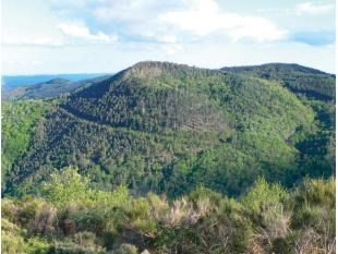 Ce volcan strombolien, comme celui de Jaujac, dessine une forme quasi parfaite.
La Coupe d’Aizac se rattachent à l’avant dernier épisode éruptif (au plus 80.000 ans)
La Coupe (# 500 mètres de diamètre), largement constituée de projections scoriacées, culmine à 808 mètres.
L’égueulement, situé du côté N-NO du cône à la cote 690 mètres, a offert le passage à une unique coulée que l’on peut suivre jusqu’aux confins de Vals (Pont de Bridou).
En effet la coulée,après buté sur le socle à l’aplomb de la Coupe, a suivi le ruisseau de Fuels sur 1500 mètres.
Parvenue à la latitude de Chastagnier, elle a emprunté le talweg de la Volane.
Du fait de l’encaissement de la vallée à cet endroit, la coulée a d’une part reflué sur 800 mètres dans le lit de la Volane (jusqu’à l’éperon du Bouchet) et d’autre part comblé partiellement les lits de la Bise et du Mas.
Le trop plein a ensuite suivi le cours de la Volane vers le sud. Ainsi que nous l’avons vu, on en retrouve la trace la plus distale à Pont de Bridou, à la porte de Vals les Bains.
Cette coulée a un profil en long très disséqué et la cote actuelle du talweg est fréquemment 20 à 30 mètres au - dessous des lambeaux conservés.
Cette érosion significative est en accord avec le fait que la Coupe d’Aizac ne relève pas du dernier épisode éruptif de l’Ardèche mais bien du précédent.
De larges lambeaux de la coulée, qui avait empli la vallée du Mas, sont encore bien observables,en rive droite du ruisseau de celui-ci. la vraie colonnade comme l’entablement sont en effet bien mis en valeur par l’érosion fluviatile
Ce que vous devez faire :
1 - PHOTO Vous pouvez vous prendre vous ou votre G.P.S. en photo devant le site (optionnel).
2 - QUESTIONS Pour se conformer aux nouvelles directives éducatives pour les Earthcaches vous devez répondre aux questions suivantes en faisant quelques recherche.Toutes les réponses sont sur les 8 panneaux d'information du sentier géologique créer que vous trouverez en montant au somment du volcan.M’envoyer un email (courriel) avec les résultats. Attendez mon accord pour faire un "found it" sur la earthcache. Merci
1 - On trouve ici des scories de différentes couleurs.Quelles sont ces couleurs?
2 - Expliquer la raison de ces différentes couleurs?
3 - Pourquoi trouve-t-on du sable sur ce volcan ?
4 - Arrivé au sommet du volcan donner l'âge des 3 autres volcans ?
5 - Pour preuve de votre présence sur les lieux .au sommet du volcan de quelle couleur est la borne qui désigne le sommet?
|
THE CUP AIZAC
|
|
This Strombolian volcano, such as Jaujac, draws a nearly perfect shape.
The Aizac Cup relate to the penultimate eruptive episode (more than 80,000 years)
Cup (# 500 meters in diameter), made up largely of projections scoriaceous, rises to 808 meters.
This lava, located on the N-NO cone 690 meters to the side, gave passage to a single casting that you can follow to the ends of Vals (Bridge Bridou).
Indeed casting after stumbled on the base at the base of the cup, followed the creek 1500 meters.
Reached the latitude of Chastagnier she borrowed the trough Volane.
Due to the collection of the valley at this point, has a casting receded 800 meters in the bed of the River Volane (up to spur Bouchet) hand and secondly partially filled beds rivers Bise and Mas.
The overflow then followed the course of the Volane south. As we have seen, we found the most distal trace Bridou Bridge, at the door of Vals les Bains.
This lava flow has a very long profile dissected and the current rating of the trough is frequently 20 to 30 meters - below shreds preserved.
This significant erosion is consistent with the fact that the Aizac Cup is not within the last eruptive episode of the Ardèche but the previous one.
Wide strips of casting, which had filled the valley of Mas are still observable on the right bank of the stream thereof. real colonnade as the entablature are indeed well highlighted by the fluvial erosion.
What you should do:
1 - PHOTO You can take you or your GPS photo to the site (optional).
2 - QUESTIONS To comply with the new educational guidelines for Earthcaches you must answer the following questions by doing some research. All responses are the 8 information panels create the geological trail you will findmuch at the summit of the volcano. Send me an email (e-mail) with the results. Wait for my agreement to a "found it" on earthcache. thank you
1 - Can be found here slag different colors What are these colors.?
2 - Explain the reason for the different colors?
3 - Why have found sand on the volcano?
4 - At the top of the volcano to the age of three other volcanoes?
5 -. Proof of your presence on the scene at the top of the volcano what color is the terminal which is the top?

Additional Hints
(Decrypt)
Enccryrm-ibhf dhr p'rfg har rnegupnpur, qbap vy a’l n av obîgr av ybtobbx !Erzrzore gung guvf vf na Rnegupnpur: Gurer vf ab obk naq ab ybtobbx !