|
Le Cirque de St Même
|

|
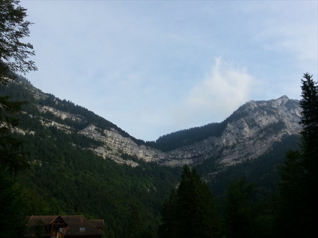 Le cirque de Saint-Même est un cirque naturel situé à l'extrémité est du massif de la Chartreuse dans les départements français de la Savoie (au nord) et de l'Isère (au sud), départements séparés par le Guiers Vif, rivière traversant le cirque.Situé à 900 m d'altitude sur les communes de Saint-Pierre-d'Entremont, le cirque fait en outre partie de la réserve naturelle des Hauts de Chartreuse.
Il est caractérisé par des couches importantes de roches urgoniennes, où se forment quatre cascades (de haut en bas : cascade des Sources, Grande cascade, cascade Isolée, Pisse du Guiers) dominées par des falaises calcaires de 500 mètres de hauteur.
La formation de ce cirque est étroitement liée à la structure tectonique du secteur, plus précisément au passage d'une grande faille, le décrochement du col de l'Alpe. Cette cassure coupe le synclinal de la Chartreuse orientale et le décale dans le sens dextre en ramenant vers l'ouest la barre de falaises urgoniennes qui forme la barrière méridionale du cirque, jusqu'en face de l'échine tithonique du Colleret (qui ferme le cirque du côté ouest). L'évidement du cirque résulte de l'ablation des terrains tendres (marnes de Narbonne) que la faille avait amené ici, dans le compartiment nord, en face de l'Urgonien du fond du synclinal du compartiment sud.
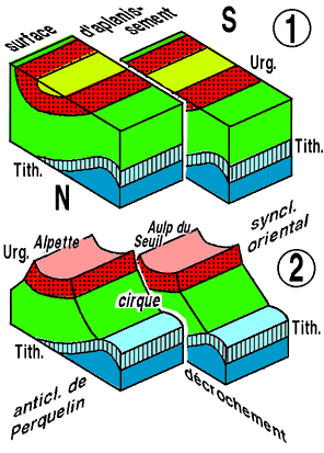 Schéma expliquant la formation du cirque de Saint-Même
1) Après le jeu du décrochement du col de l'Alpe, l'érosion du massif de la Chartreuse débute par un aplanissement qui enlève les parties saillantes des plis, quelle que soit la nature de la roche.
2) L'érosion ultérieure se fait surtout par ruissellement. Elle enlève avant tout, au contraire, les terrains les plus tendres, là où ils sont déjà mis à nu, c'est-à-dire à l'emplacement de Saint-Même. La tranche de l''Urgonien du compartiment méridional du décrochement est ainsi dégagée et le fond de la gouttière urgonienne du synclinal oriental peut laisser sortir à l'air libre les eaux qu'elle draine. Ces écoulements provoquent progressivement le retrait de la falaise, ce qui accentue le renfoncement du cirque, là où se trouvent maintenant les sources du Guiers Vif.
Source : http://www.geol-alp.com
Ce que vous devez faire :
1 - PHOTO Vous pouvez vous prendre vous ou votre G.P.S. en photo devant le site (optionnel).
2 - QUESTIONS Pour se conformer aux nouvelles directives éducatives pour les Earthcaches vous devez répondre aux questions suivantes en faisant quelques recherche.Toutes les réponses sont sur le panneau d'information (R1) .M’envoyer un email (courriel) avec les résultats. Attendez mon accord pour faire un "found it" sur la earthcache. Merci
1 : Depuis combien d'année se creuse ce cirque (millions d'années) ?
2 : Que c'est il passé il y a 110 millions d'année ?
3 : Quelle fossile ont été retrouvé ici ?
4 : Pour preuve de votre présence sur les lieux . Arrivé au point Final à quelle altitude êtes vous ? (Inscrit sur le piquet)
|
Cirque of St Même
|
|
The circus of Saint-Même is a natural cirque located at the east end of the Chartreuse in the French departments of the Savoie (to the north) and of the Isere (to the south), separate departments by the Guiers Vif, river crossing the circus.Located at 900 m of altitude on the commons of Saint-Pierre -d'Entremont, the circus is also part of the natural reserve of Chartreuse..
It is characterized by large sections of rocks urgoniennes, or form four cascades (from top to bottom: cascade of Sources, Great Waterfall, cascade Isolated, Piss of the Guiers) dominated by limestone cliffs of 500 meters of height.
The formation of this circus is closely linked to the tectonic structure of the sector, more specifically to the passage of a major flaw, the recess of the neck of the Alpe. This fracture cut the limestone synclinal fold of the Chartreuse eastern and the shifts in the direction dextre in bringing it back toward the west the bar of urgoniennes cliffs which form the southern barrier of the circus, up in front of the cowering tithonique of Colleret (which closes the circus of the west coast).The recess of the circus result of the ablation of the tender land (marls of Narbonne) that the flaw had brought me here, in the North Bay, in front of the Urgonien from the bottom of the limestone synclinal fold compartment of the south.
Diagram explaining the formation of the cirque de Saint-Même
1) After the game the unsticking of the neck of the Alpe, the erosion of the Chartreuse started by a flattening which removed the projecting parts of the folds, whatever the nature of the rock.
2) The erosion later is done primarily by runoff. It removed before all, on the contrary, the land the more tender, where they are already laid bare, that is to say, the location of Saint-Même. The installment of the 'Urgonien the southern compartment of the recess is thus clear and the bottom of the gutter urgonienne of east limestone synclinal fold can be let out in the open air the waters that it drains. These flows gradually cause the withdrawal of the cliff, which accentuates the recess of the circus, where are now the sources of the Guiers Vif.
Source : http://www.geol-alp.com
What you need to do:
1 - PHOTO You can take you or your G. P.S. in photo in front of the site (optional).
2 - QUESTIONS to comply with the new educational guidelines for Earthcaches you must answer the following questions by making a few research.All the answers are on the information panel (R1) .send me an email (e-mail) with the results. Wait for my agreement to do a "found it" on the earthcache. Thank You
1: What's happened there 110 million years?(approx.; in thousands years B.C.) ??
2: How many years have widened the circus (millions of years)
3: What fossil fuels have been found here ?
4: For evidence of your presence on the premises . Arrived at the final point to what altitude are you ? (Inscribed on the picket line))