HÖHLEN BEI CALÓ DES MORO (MALLORCA) EarthCache
HÖHLEN BEI CALÓ DES MORO (MALLORCA)
-
Difficulty:
-

-
Terrain:
-

Size:  (other)
Please note Use of geocaching.com services is subject to the terms and conditions
in our disclaimer.
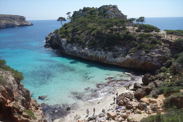
 Dieser Earthcache leitet dich zu einer unserer Lieblingsbuchten auf Mallorca: Caló des Moro. Da die Bucht recht früh im Schatten liegt, sollte dieser Earthcache nicht erst gegen Abend angegangen werden. Für diesen EC musst du zu zwei Höhlen schwimmen, anders lassen sich die Fragen nicht beantworten.
 This Earthcache guides you to one of our favorite beaches on Mallorca: Caló des Moro. Because this bay lies early in the shadow visit this spot before late afternoon. For this EC you have to swim into two caves, otherwise you could not awnser the questions.
 Esta earthcache está en uno de nos calas favorites en Mallorca: Caló des Moro. Porque la bahía es muy temprano en la sombra, esta earthcache no debe dirigirse tarde en la tarde. Para esto EC tienes que nadar a dos cuevas por responder a las questiones.
Wie kommt man zum Caló des Moro?
Parke an den gegebenen Parkkoordinaten. Folge der Treppe nach unten und geht nach links. Nutze den Durchgang vor den Häusern und folge dem Weg bis zum Mäuerchen. Nun musst du die letzten Höhenmeter bis zum Strand hinabklettern.
How do you get to Caló des Moro?
Park at the given co-ordinates of the parking area. Follow the stairs down and turn left. Use the path in front of the houses and follow it to the little wall. Now you have to climb down to the beach.
¿Cómo llegar a Caló des Moro?
Desde el aparcamiento tome las escaleras hacia abajo y vas a la izquierda. Tome el camino delante de las casas y seguis el camino hasta un muro pequeno. Ahora tiene que bajar a la playa.
Geologie:
Die Höhlen bei Caló des Moro sind durch verschiedene Erosionsarten entstanden.
Was versteht man unter Erosion?
Unter Erosion (von lateinisch erodere = abnagen) versteht man die Zerstörung bzw. Schaffung von Oberflächenformen durch die Abtragung von mehr oder weniger stark verwitterten Gesteinen einschließlich der Böden.
Man unterscheidet nach der Eorsionsform zwischen
1.) linienhafter(linearer) Erosion:
Darunter versteht man die Eintiefung der Erdoberfläche durch abfließendes Wasser in kleinen, kurzlebigen Rinnsalen (Rillenerosion) oder in Fließgewässern (fluviatile oder Flusserosion) bzw. die Entstehung V- oder U-förmiger Täler durch glaziale (durch Gletscher verursachte) Erosion.
2.) flächenhafter Erosion
Die flächenhafte Erosion erfolgt äolisch (durch Wind), marin (durch Meeresbrandung und -Strömung), glazial durch Inlandeis und gelegentlich auch direkt durch Niederschläge. Die großflächige Abtragung und Einebnung ganzer Landoberflächen wird als Denudation bezeichnet.
Beide Erosionsformen sind nicht klar voreinander abzugrenzen.
Natürliche Erosion erfolgt meistens unter Einwirkung von Wasser, Eis oder Wind (strömendes Medium).
Das Material des Untergrundes, welches vorher oft durch Verwitterung physikalisch und chemisch zu Lockermaterial (Gesteinsschutt, Sand, Boden) umgewandelt wurde, wird abgeführt, wenn die durch das strömende Medium erzeugte Scherspannung auf die zu erodierenden Partikel stärker ist als die Haftreibung der Partikel untereinander.
Erodiertes Material, das bereits vom strömenden bzw. fließenden Medium mitgeführt wird, kann dessen Erosionswirkung deutlich erhöhen.
Das Ausmaß der Erosion, welche durch die oben genannten Mechanismen hervorgerufen wird, hängt auch maßgeblich von der Geologie, sprich: der Beschaffenheit des Untergrundes ab. Die Erosionswirkung ist umso stärker, je geringer die Erosionsresistenz des Untergrundes ist.
Die Erosionsresistenz des Untergrundes ist abhängig von der Gesteinsart, aus dem er besteht. Lockermaterial ist leichter erodierbar als solider Fels, Sand also leichter erodierbar als Sandstein. Feinkörniges Material ist leichter erodierbar als grobkörniges Material, Tonstein also leichter erodierbar als Sandstein. Magmatische Gesteine, wie Basalt oder Granit sind in der Regel schwerer erodierbar als Sedimentgesteine.
Je nach Art des strömenden Mediums und der entstehenden Erosionsform unterscheidet man z.B. Rillenerosion, Flusserosion, glaziale Erosion (durch Gletscher), Abrasion (durch Meer), äolische Erosion (durch Wind), Denudation (flächenhafte Abspülung durch Regen), Piping (Röhrenbildung), Efforation (durch hohen Wasserdruck), Weltraumerosion (durch Meteoriten), submarine Erosion...
Im folgenden sollen zwei dieser Erosionsarten näher erläutert werden:
1.) Abrasion = marine Erosion
Diese Erosionsform greift das Festland auf breiter Front an und lässt sich besonders gut an Steilküsten beobachten. Dort führt die Arbeit der Brandung am Kliff zur Entstehung von Brandungshohlkehlen und anderen Hohlräumen im Gestein, die mit der Zeit einstürzen. Dadurch wird die Küstenlinie ins Landesinnere zurückgedrängt und auf Meeresniveau entsteht eine immer breiter werdende Fläche, die Abrasionsplatte (auch: Brandungsplattform oder Felsschorre). Abrasion ist linear bis flächig.
2.) Winderosion = äolische Erosion
Wind wirkt vor allem dann erosiv, wenn er viel Material (Staub, Sand) mit sich führt (äolischer Transport), das dann ähnlich einem Sandstrahlgebläse am anstehenden Gestein des Untergrundes nagt (siehe z. B. Pilzfelsen). Dies tritt bevorzugt in ariden Gebieten (Wüste) bei geringer Vegetation und starker physikalischer Verwitterung auf. Winderosion ist vollflächig. Bei der Winderosion wird unterschieden nach Deflation (bezeichnet das Wegblasen von Feinpartikeln, die bei der Verwitterung angefallen sind) und Korrasion (bezeichnet die aktive Erosion, also die abschleifende Wirkung auf Felsen und Steine durch Sandpartikel).
Um diesen Earthcache als Found zu loggen maile uns vorher die Antworten auf folgende Aufgaben:
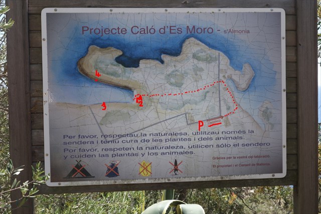
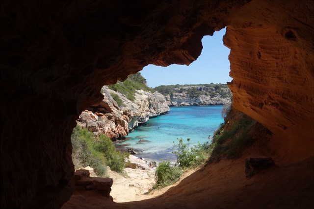
1.) Steige hinab zum Strand Caló des Moro und drehe dich dann um 180° zu der Wand um, die du gerade herunter geklettert bist. Dort siehst du den Eingang zu zwei Höhlen (Höhle 1 und 2).
a) Aus welchem Gestein bestehen sie? Sandgestein oder Kalkgestein?
b) Erkläre kurz durch welche Erosionsart, diese beiden Höhlen deiner Meinung nach entstanden sind.
c) Was findest du in der linke Höhle mehrfach auf Augenhöhe?
2.) Präge dir nun die weiteren Fragen gut ein, denn jetzt musst du zu zwei weiteren Höhlen schwimmen. Die erste befindet sich auf der linken Buchtseite ca. 50m vom Strand (Höhle 3), die zweite auf der rechten Buchtseite, dort wo die größeren Felsblöcke im Wasser liegen (Höhle 4).
d) Begründe, ob deiner Meinung nach diese beiden Höhlen durch Abrasion entstanden sind.
e) Schätze jeweils die Länge der Abrasionsplatte (siehe Erklärung oben und Zeichnung) auf der jeweils linken Seite von Höhle 3 und 4, wenn man von innen nach außen schaut und versuche den Unterschied zu erklären.
f) Gibt es in einer der beiden Höhlen Anzeichen von Tropfsteinen?
g) Wie ist der Boden jeweils in den beiden Höhlen? Z.B. komplett sandig, hauptsächlich sandig, hauptsächlich felsig, komplett felsig...
h) Was befindet sich in der Höhle 4 ganz hinten an der Decke?
i) Edit: 2.8.2021: Foto von dir, Teilen von dir, deinem GPS... im Online-Log erforderlich (wiedererlaubt bei GC seit Juni 2019)
Hab viel Spaß in der Bucht und über hochgeladene Fotos freuen wir uns!
![]()
Geology:
The caves at Caló des Moro develope through different kinds of erosion.
What is erosion?
Erosion ( latin erodere = to gnaw sth.) is the destruction or the creation of surface shapes by the removal of more or less heavily weathered rocks including the floors.
The following distinction is made due to the form of erosion:
1.) linear Erosion:
This is the depression of the surface through running water in little. short living flows (rill erosion) or streaming water (fluvial erosion) or the evolution of V- or U-valleys through glaciers.
2.) areal erosion
Arial erosion occurs through wind (aeolic), marin (through breakers and currents), glacial and sometimes through rain. A big arial erosion and flattening of a hugh surface is called denudation.
Both forms of erosion are not clearly seperated.
Natural erosion is caused usually by the impact of water, ice or wind (drifty medium).
The material of the underlying ground, which was often converted physically and chemically through weathering into granular soil or sand, will be discharged if the tense through the drifty medium that acts on the eroded particle is higher then the adhesion of the particle among itsselves.
Eroded material, which is allready carried along with the drifty medium, might increase the eroding effect.
The extent of erosion, which is caused by the mechanisms mentioned above , also depends largely on the geology: the nature of the substrate of the underlying ground. The erosion effect is stronger the lower the erosion resistance of the substrate is.
The erosion resistance of the surface depends on the rock type, from which it is made. Unconsolidated material is more erodible than solid rock, sand more erodible than sandstone. Fine-grained material is more erodible than coarse-grained material, claystone more than sandstone. Igneous rocks, such as basalt or granite are usually more difficult to erode than sedimentary rocks.
Depending on the nature of the drifty medium and the resulting erosion form a distinction is rill erosion, river erosion,glacial erosion, abrasion (=marine erosion), aeolic erosion (wind), denudation (arial washing-up through rain). piping (evolition of tubes), efforation (through high water pressure), space erosion (through meteorites), submarine erosion...
In the following, two of these erosion types are explained in more detail :
1.) Abrasion = marine erosion
This erosion form attacks the mainland across the board and can be particularly well observed on cliffs. There the work of the surf on the cliff leads to the emergence of surf fillets and other cavities in the rock, which collapse with time. Thus, the shoreline is forced back inland and at sea level created an ever -widening area (abrasion platform). Abrasion is linear to areal.
2.) Wind erosion = aeolic erosion
Wind affects especially erosive if it carries along a lot of material (dust, sand) ( aeolian transport) , then the similar gnaws like a sandblaster on the surrounding rock of the substrate. This occurs primarily in arid areas ( desert ) with low vegetation and strong physical weathering. Wind erosion is areal. Wind erosion is distinguished by deflation (blowing of fine particles that are accumulated during the weathering ) and corrasion (active erosion , so the abrasive effect on rocks and stones by sand particles).
To claim this earth cache as a found mail us before online logging the awnsers to the following tasks:
1.) Climb down to the beach of Caló des Moro and turn around to the wall you just climbed down. There you will see the entrance to two caves (cave 1 and 2).
a) These caves are made of which stones? Sandstones or limestones?
b) Explaine shortly the type of erosion that causes these two caves in your opinion.
c) What is in the left cave several times in at eye height?
2.) Memorize now the other questions , because now you've got to swim into two other caves. The first is situated at the left side of the bay about 50m away from the beach (cave 3), the second one at the right side of the bay, there were the bigger rocks are lying in the water, about 60m away from the beach (cave 4).
d) Explain whether you think these two caves are formed by abrasion.
e) Suppose the length of each abrasion platform (see explanation above and my drawing) on each left side of the cavity 3 and 4 , when viewed from the inside outwards and try to explain the difference.
f) Are stalactites or -mites in one of these caves?
g) Tell me how is the ground in cave 3 and cave 4 respectively? For example completely sandy, almost sandy, almost rocky, completely rocky...
h) What is in cave 4 on the ceiling at the back of the cave?
i) Edit 2.8.21: Foto-upload of you, part of you, your GPSr... in your online-log is required (re-allowed by GC since June 2019)
Have fun at Caló des Moro! It would be nice if you upload some photos.
![]()
Geología
Esta es una traducción automática con www.babelfish.de. If someone is willing to do it better please feel free to contact us.
. Las cuevas de Caló de Moro desarrolladas por la erosión.
¿Qué es la erosión?
La erosión (lat. erodere = rosigar algo) es la destrucción o la creación de formas superficiales mediante la supresión de las rocas más o menos fuertemente resistidas.
Se hace una distinción según la forma de erosión entre
1.) erosión linear:
Esto se refiere a la erosión de la superficie de la tierra por el agua de escorrentía en pequeñas riachuelos efímeras o erosión fluvial o la génesis de valles en forma de V o U mediante de erosión glaciar.
2.) erosión bidimensional
La erosión bidimensional ocurre eólica (viento) , marino (por la resaca del océano y el flujo ) , el hielo glacial a través y en ocasiones directamente por las precipitaciones. La eliminación a gran escala y nivelación de toda la superficie de la tierra se llama la denudación.
Ambas formas de la erosión no se delimian claramente.
La erosión natural se produce principalmente por la acción del agua, el hielo o el viento (fluye medio).
El material del sustrato , que fue previamente menudo transformada por la intemperie física y químicamente para material suelto ( restos de roca , arena, tierra ) se descarga cuando la tensión de cizallamiento generada por el medio que fluye más sensibles a ser erosionado partículas que la fricción estática entre las partículas.
El material erosionado que ya está siendo llevado por el medio que circula o fluye puede aumentar su efecto erosión significativa.
El grado de erosión, que es causada por lo anterior mencionado mecanismos depende también de la geología, dice: la naturaleza de la subsuperficie hacia abajo. El efecto de erosión es más fuerte cuanto más baja sea la resistencia a la erosión del sustrato.
La resistencia a la erosión de la superficie depende del tipo de roca, de la que está hecha. Material no consolidado es más erosionable que la roca sólida, la arena que sea más erosionable de la piedra arenisca. Material de grano fino es más erosionable que el material de grano grueso, arcilla fácilmente como areniscas arcillosas. Las rocas ígneas , como el basalto o el granito son por lo general más difícil de desgastar a las rocas sedimentarias.
Dependiendo de la naturaleza del medio que fluye y la forma resultante es diferente , por ejemplo , la erosión fluvial , erosión glaciar , abrasión (por mar ) , la erosión eólica ( por el viento ) , la denudación ( areal lluvia enjuague) , piping ( formación de tubos ) , efforation (debido a la alta presión del agua ) , la erosión del espacio ( meteorito ), erosión submarina ...
En lo que sigue, dos de estos tipos de erosión se explican con más detalle:
1.) Abrasion = erosión marina
Esta forma de erosión ataca el continente a través del tablero y puede ser particularmente bien observó en los acantilados. Allí el trabajo de surf en el acantilado conduce a la aparición de garganta hueca surf y otras cavidades en las rocas que tiempo se derrumban. Así el interior de la costa será lanzado hacia atrás y a nivel del mar un expectante siempre más amplio, un plano de abrasion. Abrasion es linear hasta bidimensional..
2.) erosión eólica = erosión de viento
Viento afecta especialmente erosiva si lleva consigo una gran cantidad de material (polvo, arena) (transporte eólico), entonces roe el parecido un chorro de arena sobre la roca circundante del subsuelo. Esto ocurre principalmente en zonas áridas ( desiertos) en al vegetación baja y fuerte desgaste físico. La erosión eólica es de gran tamaño . Cuando la erosión eólica distingue por la deflación (denotado soplando de finas partículas que se acumulan durante la meteorización ) y corrasion ( designado a la erosión activa, por lo que el efecto abrasivo sobre las rocas y las piedras de las partículas de arena ).
Antes de que marcar esta Earthcache como Found me envía un e-mail, con las respuestas a preguntas a seguir:
1.) Bajar a la playa de Caló des Moro y girar alrededor de 180 grados a la pared a la que estás bajó. Allí podrá ver la entrada a dos cuevas (cueva 1+2).
a) Por alguna roca hechas? Arenisca o cal?
b) Explique brevemente qué type de erosión estas dos cuevas se forman en tu opinión.
c) ¿Qué encuentras en la cueva izquierda varias veces a la altura de tu ojos ?
2.) Memorice ahora las otras preguntas uno bueno, porque ahora tienes que nadar en dos aditional cuevas. El primero se encuentra en el lado izquierdo de la bahía a unos 50 metros de la playa (cueva 3), la segunda cueva se encuentra en el lado derecho de la bahía, donde los cantos rodados grandes estan en el agua (cueva 4).
d) Explique si crees que estos dos cuevas se forman por la abrasión.
e) Supongamos que la longitud de cada plano de abrasion (ver explicación arriba y mi dibujo) en cada lado izquierdo de la cueva 3 y 4 es, cuando se ve desde el interior hacia el exterior y tratar de explicar la diferencia.
f) ¿Hay estalactitas en una de los dos cuevas?
g) ¿Cómo es el piso en las dos cuevas? Por ejemplo totalmente arenoso, principalmente arena, principalmente rocky, totalmente rocky...
h) ¿Qué hay en la Cueva 4 en la parte posterior en el techo?
i) Edit 2.8.21: Foto-upload of you, part of you, your GPSr... in your online-log is required (re-allowed by GC since June 2019)
Have fun y sobre las fotos, nos complace.
Source: Artikel Erosion in www.wikipedia.de

Additional Hints
(Decrypt)
Qb abg sbetrg lbhe onguvat fhvg!