TRILHOS DE SÃO MIGUEL


Esta geocache é uma homenagem, justa e merecida, a todas as pessoas e organizações/entidades (Direção Regional do Ambiente, Serviços Florestais, grupos dos Trilhos,…) que criam e mantêm todos os trilhos que existem em S. Miguel e nos Açores, em geral. Estes trilhos são muito úteis à população em geral, aos escu(o)teiros, bem como a todos os turistas que nos visitam e muito em particular aos geocachers.
Lomba da Fazenda – Pico da Vara
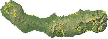
Este trilho começa na Lomba da Cruz, freguesia da Lomba da Fazenda, e termina no Pico da Vara. Após alcançar o cume pode-se descer pelo mesmo caminho ou optar pelo percurso PR-7-SMI que termina na Algarvia. O trilho inicia-se por um caminho de terra batida localizado numa zona de pastagens e após cerca de 400m chegará a um bebedoiro onde deverá seguir o caminho em frente entrando numa mata de Criptomérias. Depois de aproximadamente 1 km chegará a uma bifurcação onde deverá voltar à direita e, continuando sempre em frente, chegará a uma zona mais aberta com uma vista panorâmica sobre o Vale da Ribeira do Guilherme. Aqui o trilho, que entra numa zona de vegetação arbustiva, encontrando-se muitas espécies endémicas, torna-se mais estreito e segue sempre ao longo do cume até ao Pico da Vara.
A CACHE:
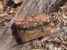
Atenção à foto spoiler e aos atributos.
Recomendado trabalho de equipa.
SÃO MIGUEL TRAILS


This geocache is a, just and deserved, tribute to all persons and organizations / entities (Regional Directorate of Environment, Forestry Services, Railings groups, ...) that create and maintain all the trails that exist in S. Miguel and the Azores, in general. These rails are very useful to the general population, the scouts/seascouts as well as all the tourists who visit us, and in particular to the geocachers.
Lomba da Fazenda – Pico da Vara
This trail begins in Lomba da Cruz village of Lomba da Fazenda, and ends at Pico da Vara. After reaching the summit you can go down the same path or opt for the route PR-7-SMI ending in the Algarvia. The trail begins by a dirt road located in a pasture area and after about 400m reach a bubbler where you should follow the path ahead entering a cedar wood. After approximately 1 km you will reach a fork where you should turn right and always continue straight, reach a more open with a panoramic view over the valley of Ribeira do Guilherme area. Here the trail that enters a shrub zone, lying many endemic species, it becomes narrower and always follows along the ridge to Pico da Vara.
THE CACHE:
Attention to the spoiler photo and attributes.
Recommended teamwork.