Système Britannique Modifié
Modified British System
Les forces armées engagées dans la deuxième guerre mondiale furent amenées à définir et à utiliser des systèmes de coordonnées géographiques spécifiques afin de préciser la localisation de sites ou de cibles situées sur le théâtre d'opérations.
En 1919, la Grande-Bretagne adoptait sur son territoire le "Système Britannique". Ce système était remplacé en 1927 par le "Système Britannique Modifié", plus adapté à la couverture de vastes zones géographiques et à une utilisation militaire opérationnelle par des forces terrestres ou aériennes.
Ce système "Britannique Modifié" allait être utilisé durant la seconde guerre mondiale par les armées britanniques et américaines en étant étendu aux théâtres d'opérations de l'Europe, de l'Afrique du Nord, du Proche-Orient et de l'Asie du Sud-Est.
L'imprécision de la détermination est évaluée entre 5 et 30 secondes d'arc, ce qui correspond
à un écart sur le terrain compris entre 150 et 1000 mètres. Vérifiez votre réponse au checker pour avoir les coordonnées précises.
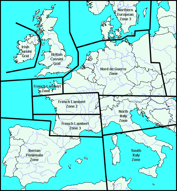
The Army Forces involved in the WWII were for the most brought to define and to use specific geographical coordinate systems in order to specify the localization of points or targets located on the theater of operations.
In 1919, Great Britain adopted on its territory the "British System". This system was superseded in 1927 by the "Modified British System", more adapted to the coverage of large areas and to a military operational use by terrestrial and aerial forces.
This "Modified British System" was going to be used during the World War II by the British and American Armies, while being extended to the European, North African, Middle East and South-East Asian theatres of operations.
The imprecision of the determination is evaluated between 5 and 30 arc-seconds (this corresponds to an imprecision varying from 150 to 1000 meters on the field) : check your answer for the real coordinates.
vT413759