Rocks at Lake Victoria in the heart of Africa EarthCache
Rocks at Lake Victoria in the heart of Africa
-
Difficulty:
-

-
Terrain:
-

Size:  (other)
Please note Use of geocaching.com services is subject to the terms and conditions
in our disclaimer.
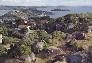
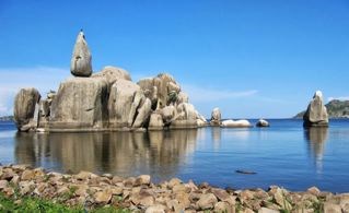
Mwanza (Tanzania) is called by its impressive rock formations - Rock City.
The stones and rocks are in, on and around the lake in the most beautiful formations, granular igneous plutonic rock and the stones, for millions of years in their places.
Their impressive geomorphological phenomenon is unique to this region.
Geography & History
Mwanza region is one of Tanzania's 30 administrative regions. The regional capital is Mwanza, located on Lake Victoria, the largest freshwater lake in Africa and the second largest lake in the world.
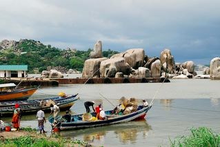
A sight closely associated with Mwanza if not a feature of the city, off shore in the lake are found the so called Bismarck-rocks, named after the most famous German Chancellor in the days prior to the World Wars, who served his Kaiser at a time when the notorious Berlin Conference, which divided Africa and Africans into colonial possessions, created boundaries over which modern African countries today still are in dispute.
But these rock formations are not just found off shore but also scattered around on land, huge boulders of rocks, a sight incidentally also found in the Serengeti where these rock outcrops, which look as if they have just escaped the earth, are called Kopjes.
Much myth and much history are attributed to some of those rocks by the African tribes which lived on the lake shores for time immemorial, since this part of Eastern Africa was long proven to be the cradle of mankind from which modern man evolved.
Geology
Bismarck-Rock, a natural balanced granite formation that lies within the main harbor of Mwanza, but several similarly impressive outcrops can be seen in the region.
The extremely heavy rock is granite rock, a granular igneous plutonic rock and the stones are for millions of years in their places. By movements of the earth's crust then get into more upper layers of the earth and solidify. It will be removed in the upper layers of soil over 10.000 of years and the stones slowly by further erosion and water rinses come to the surface and it incur the round shapes.
Granite caused by the solidification of molten rock (magma) within the continental crust, usually at a depth of more than 2 km below the surface. It solidifies at greater depths of the earth's crust of an intruding magma at about 700 ° C.
Did you know?
The extremely heavy rock is granite rock, a granular igneous plutonic rock and the stones are for millions of years in their places.
Structure & mineral components
Granite is an igneous rock with directionless - grained structure. It consists essentially of alkali feldspar and plagioclase, quartz and different sized proportions of hornblende and/or biotite. The grain diameter can be marked by several centimeters into the size.
Origin & appearance today
Rock formations are folded, fractured, uplifted and eroded again. Due to dynamic processes, over millions of years, the region was subject of orogeny several times. The look of today is characterized by the uplifted and eroded plutonic rocks.
Due to the still continuing, dating back to tectonic movement of the earth's crust uplift and accompanying erosion of the so-called cap rock, the rocks were eroded again.
The harder, more resistant to weathering rocks were carved out from the surroundings. Today they form distinctive shapes in the landscape. One such example are the granite boulders on the southern coast of Lake Victoria.
Did you know?
The rocks are large granitic boulders that form the exposed top layer of an extensive and mostly underground granite formation. The natural processes of weathering and erosion have created the various shapes of the boulders. Some of the boulders are naturally but precariously balanced atop one another or on larger rock formations.
The rocks are made of granite and are part of the top layer of a formation which penetrates the ground from below, like little geological islands, surrounded by sedimentary rocks. The granite was formed millions of years ago as a result of the hardening of magma within the Earth's crust. Thick layers of sedimentary rocks on top of the granite exerted extreme downward pressure on the granite. After some time, tectonic forces caused folding of the Earth's crust in the area, which lifted the granite and fractured the sedimentary rocks (eventually forming the ancient greenstone belts today), allowing the granite to come closer to the surface. As the pressure diminished, the granite expanded causing cracks to form, and then the larger formations began to separate into big, square blocks.
The next phase of the Bismarck-rock granite formation started when the blocks were exposed to water. The surface of the blocks began to decay under the influence of the water and a layer of loose material surrounded the individual blocks. When the blocks came to the surface completely, the loose material was eroded away by water and wind.
The rounding of the granite blocks is a result of chemical and physical (also called mechanical) weathering. Chemical processes cause the surface of the blocks to expand and contract, resulting in thin layers of rock coming off the boulder in a process called exfoliation. This process rounds the granite block because the chemical processes have more effect on areas with edges. The rock begins to look like it is made of layers like an onion. Only the outer few centimeters are affected by chemical weathering in a process called spheroidal weathering.
The boulders are affected more deeply by the extreme temperature differences between day and night in the region where the Mwanza is located. During daylight hours the rocks expand slightly and after nightfall they contract slightly, repeating the process every 24 hours. These repeated cycles of expansion and contraction, called thermal stress weathering, create cracks which sometimes go so deep that the boulder is completely split in half.
Did you know?
A special feature of the plutonic rocks is not the origin but in the art of its weathering and the resulting appearance in the landscape.
Picture 1:
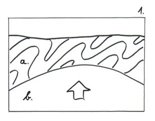 a.) Tectonically folded layers of sedimentary rocks (eventually forming the ancient greenstone belts today), formed the previous formation.
b.) The granite was formed millions of years ago as a result of the hardening of magma within the Earth's crust.
Picture 2:
Thick layers of sedimentary rocks on top of the granite exerted extreme downward pressure on the granite. After some time, tectonic forces caused folding of the Earth's crust in the area, which lifted the granite and fractured the sedimentary rocks, allowing the granite to come closer to the surface.
c.)As the pressure diminished, the granite expanded causing cracks to form, and then the larger formations began to separate into big, square blocks.
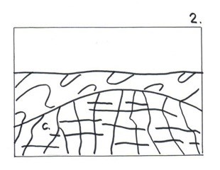
Picture 3:
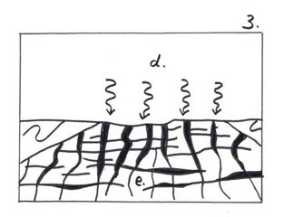
d.) The next phase of the granite formation started when the blocks were exposed to water.
e.) The surface of the blocks began to decay under the influence of the water and a layer of loose material surrounded the individual blocks.
Picture 4:
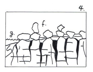
f.) When the blocks came to the surface completely, the loose material was eroded away by water and wind. The rounding of the granite blocks is a result of chemical and physical weathering.
g.) Victoria Lake and Bismarck-rock formation as today.
Their impressive geomorphological phenomenon is unique to this region.
Many residents see traditional forms in the rocks and in fact one can again see an elephant and ...
Otherwise, people arrange here with the rocks. Where they cannot be out of the way, you make your bed simply into the architecture, used as a picnic spot, climbing or hiding places for treasure hunting / geocaching.
Your task
To log this Earthcache you need to answer following questions:
1. Please go to the rock group and have a closer look (see picture). Please describe the arrangement and distribution of minerals included with your own words.
2. Port: What is the name of the famous rock group, which overlooks the lake on the left ?
3. Located in the background of the famous rock group - which of the great market can be seen in the distance? _ _ _ _ Market
or 3. Alternative question to the market: At which height above sea level is the famous rock group?
Please send your response via my profile in english oder german and log this Earthcache. If there is a problem, we will contact you to resolve it. If there is no problem, then your log simply stands.
If you like to, just take a picture of yourself and/or of your GPS with the granitic boulders in the background and upload it along with your log (optional).
Caution!
Please be careful when you go hiking on the trail below the rock group (rockfall hazard). The cache owner is not responsible for accidents!
In any case you should wear sturdy footwear and weatherproof clothing. You mustn't be afraid of heights.
Geology support and pictures 1-4 by ebbitroll
Thank you very much ebbitroll!

Additional Hints
(No hints available.)