|
*Introdução*
A única maneira de conseguirmos arrancar os recursos do interior da terra é criar maneiras para chegar a esses recursos. Uma das maneiras é construir galerias ligadas em rede para nos darem acesso a vários locais ao mesmo tempo tal como é feito numa mina. A entrada para uma mina tem o nome de galeria.
 *O que é uma galeria?* *O que é uma galeria?*
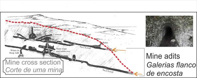
Uma galeria é uma abertura mais ou menos horizontal, que dá acesso (ou não) ao poço da mina. Normalmente é construída para que a boca da galeria esteja a uma cota mais baixa do que o seu ponto central dentro da mina para possibilitar a drenagem de águas do interior da mina. As galerias servem par nos permitir o acesso a jazidas. As galerias flanco de encosta são escavadas nos flancos de uma montanha.
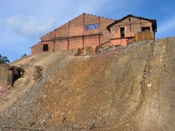
*A Mina do Lousal*
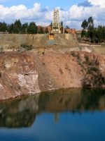
A mina de Lousal é uma mina de pirite abandonada em Portugal dentro da Faixa Piritosa Ibérica. A mina foi inaugurada em 1900 e fechada em 1988. É um depósito de sulfureto maciço vulcanogénico (VMS) hospedado em estrutura antiforma. Existem dois horizontes de sulfuretos n a estrutura antiforme do Lousal: o grupo ocidental formado pelos corpos Extremo Sul, Sul e Oeste e o grupo oriental formado pelos corpos de sulfureto António, Central, Miguel, José, Fernando, Norte e Nordeste. As rochas hospedeiras da mineralização são o CVS (Complexo Vulcano Sedimentar), que aflora na Faixa Piritosa Ibérica.
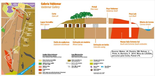
*A Galeria Valdemar*
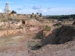
Esta galeria, construída em flanco de encosta permite realizar um pequeno percurso subterrâneo no sector sul da mina do Lousal. Com cerca de 280m de comprimento, o túnel liga a corta ao chapéu de ferro da massa Extremo Sul. A galeria possibilita a visita aos antigos paióis (quatro salas revestidas a betão) localizados do lado esquerdo do túnel, a um sector com entivação em madeira e aos poços Valdemar e Luís que, com uma profundidade aproximada de 35m, permitiam o acesso aos pisos inferiores.
Ao longo do trajecto observam-se xistos do Grupo Filito-Quartzítico (Famenniano) e xistos negros com níveis de sulfuretos oxidados do Complexo Vulcano Sedimentar de idade Estruniana. Estas duas formações encontram-se separadas por uma fractura importante, a falha de Corona.
 *Para reclamar esta EC*, devem enviar ao owner as respostas às seguintes perguntas: *Para reclamar esta EC*, devem enviar ao owner as respostas às seguintes perguntas:
1- A secção da entrada da galeria é redonda ou quadrada?
2- Estima a orientação de inclinação das rochas à entrada da galeria. Esta inclinam para norte, sul, este ou oeste?
3- Baseado na descrição geológica no painel informativo, que rochas pensas estarem a aflorar à boca da galeria?

*Introduction*
The only way to wrench the resources from the earth is to create ways in to get at those resources. One of the ways is to build an adit linked to a much wider network of shafts, tunnels and structures that make up a mine. The entrance to a mine is called an adit. An adit is a more or less horizontal opening,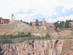 giving access to the shaft of a mine. It is made to slope gradually from the farthest point in the interior to the mouth, and by means of it the principal drainage is usually carried on. giving access to the shaft of a mine. It is made to slope gradually from the farthest point in the interior to the mouth, and by means of it the principal drainage is usually carried on.
*What is an adit?*
Adits are horizontal or slightly inclined tunnels excavated into the earth to allow access to orebodies. Adits are driven into the side of a hill or mountain, and are often used when an ore body is located inside the mountain but above the adjacent valley floor or coastal plain. In cases where the mineral vein outcrops at the surface, the adit may follow the lode or vein until it is worked out, in this case the adit is rarely straight. Adits can only be driven into a mine where the local topography permits. There will be no opportunity to drive an adit to a mine situated on a large flat plain, for instance. Also if the ground is weak, the cost of shoring up a long adit may outweigh its possible advantages.
*The Lousal Mine*
The*Lousal mine* is an abandoned pyrite mine in Portugal within the Iberian Pyrite belt. The mine was opened in 1900 and closed in 1988. It is a Volcanogenic Massive Sulphide (VMS) hosted in an antiform structure. Two massive sulfide horizons can be considered at Lousal antiform structure: the western group formed by 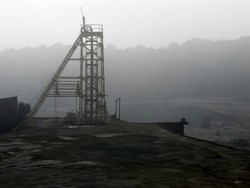 the Extreme South, South and West sulphide lenses and the eastern group formed by the Central, Miguel, José, Fernando, North, Northeast and António sulphide lenses. The host rocks of mineralization are the VSC (Volcanic Sedimentary Complex) common within the Iberian Pyrite belt. the Extreme South, South and West sulphide lenses and the eastern group formed by the Central, Miguel, José, Fernando, North, Northeast and António sulphide lenses. The host rocks of mineralization are the VSC (Volcanic Sedimentary Complex) common within the Iberian Pyrite belt.
*The Valdemar adit*
Located in the southern sector of the Lousal Mine, The Valdemar adit allows the connection between the open pit and the Valdemar and Luís shafts. The total extension is 280m and the depth of the mining works is 35m. The southern sector of the adit corresponds to the gossan area of the Extreme South orebody and where the Luís Shaft is located. The addit runs through four wider concrete lined openings that were used for explosives storage. Propping was done though timber casing and piles. Geologically, the adit traverses shales and phyllites of the PQ Group (Fammenian age) as well as black shales with oxidized massive sulphides of the VSC (Strunnian age).
*Claiming the EC*
Reply to the following questions and send them to the CO (leinadoligc@gmail.com) to validate your found.
1- Is the Cross section of the entrance of the adit round or square?
2- Estimate the orientation of the rocks at the entrance of the adit. i.e. do they dip to the north, south, east or west?
3- Based on the geological description of the rock types that are cut by this adit, what do you think are the rock types that outcrop at the entrance of the adit?
Stay safe and enjoy your stay.

|