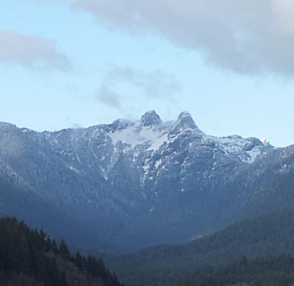
The Lions are an icon of Vancouver. There is a bridge, a football team, and a film production company named after them. The lions are represented at the south entrance to the Lions Gate Bridge, on the steps of the Vancouver Art Gallery downtown. There are miniature replicas on the deck of the Marine Building and on the bridge over the Stanley Park Causeway. North Shore Rescue, the SAR group that rescues lost and injured hikers on the North Shore mountains has them on their logo. The Lions are the most distinct of the local mountains.
The Squamish Nation name for the peaks is Ch'ich'iyúy Elxwíkn", or Twin Sisters. Somewhere around 1890 Judge John Hamilton Gray proposed renaming them The Lions from heraldry, reminiscent to the Lions of Trafalgar Square in London.
The Squamish name comes from legend. Two sisters were coming of age for marriage. A great potlatch was planned. The Squamish Nation had long been in battle with the Haida Nation. The girls asked their father to invite the enemy nation to their potlatch. As was custom the father could not refuse the request. The Haida came and the potlatch lasted for weeks and led to peace between the two warring nations. The great Sagali Tyee was so pleased he lifted the sisters and placed them for eternity where they remain today at the head of the Capilano Valley. For the full legend click HERE
Geology
Geologically The Lions are part of the Coast Mountain range, the most westerly of the numerous mountain ranges on the continental side of British Columbia. Formed in the Cretaceous Age, roughly 120 million years ago these are the oldest rocks on the West Coast of North America. As the North American Plate inches westward, the Juan de Fuca plate subducts (slips under) it as it moves eastward. The result is that the rock is uplifted and essentially squished into a mountain range.
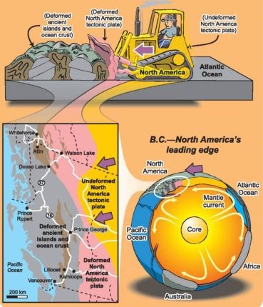
Graphic courtesy Natural Resources Canada
What shaped the Lions is somewhat unclear. The Lions do not have any notable formations that are different from the surrounding mountains. They are made up of a combination of igneous granitic type rock, primarily quartz diorite with horneblende or biotite. 15,000 years ago the Vancouver area was under about a kilometre of ice. The peaks of the Lions would have been above that level. Obviously the climate was much different then. While the rock under the ice was being eroded through grinding and pressure that smoothed and rounded the landscape, the peaks of the Lions were exposed to the elements and were subjected to freeze/thaw cycles that break apart rock from small cracks and fissures.
To log this Earthcache
1. The summit of the West Lion is located at N 49 27.468 W 123 11.183. Standing on a metal square close to GZ, calculate the distance the approximate bearing.
2. Compare The Lions (1646 M) to the mountains closest to you. Grouse Mountain (1231 M) is to your right as you face The Lions; and Mount Hollyburn (1326 M) is to your left. Name at least two differences between them as far as their physical appearance. Can you explain why?
3. Can you describe where you expect that the top level of glacier ice reached on The Lions? Why?
Please send your answers to me through my profile. Do not post any answers in your log. As always, pictures are appreciated. Thanks for visiting the Earthcache!
References:
http://www.gac-cs.ca/publications/VancouverGeologyMap.pdf
http://digital.library.upenn.edu/women/johnson/vancouver/vancouver-01.html
Vancouver, City on the Edge, John Clague & Bob Turner
Sea to Sky Geotour, Natural Resources Canada
http://publications.gc.ca/collections/collection_2010/nrcan/M4-83-7-2010-eng.pdf
Southern BC Geological Landscapes Highway Map, Natural Resources Canada
http://geogratis.gc.ca/api/en/nrcan-rncan/ess-sst/b5414e41-ae4e-5e96-88fd-221cb0f75b77.html