Lake William in Barboursville Park is a popular place for fitness walkers, anglers and visitors just wanting a quiet place to relax. The small impoundment is stocked with trout in January and March and warmwater fishing for bluegill, bass and catfish is available throughout most of the year.
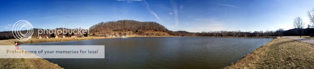
There are several ponds around Barboursville Park but Lake William is the only one developed with a walking path and fishing piers.
Limnologists consider ponds to be bodies of water that are shallow enough for light to penetrate to the bottom allowing emergent plants like cattail to grow. Other definitions of a pond are “bodies of water that hold water for at least four months a year and are between 1 square meter and 20,000 square meters in surface area”.
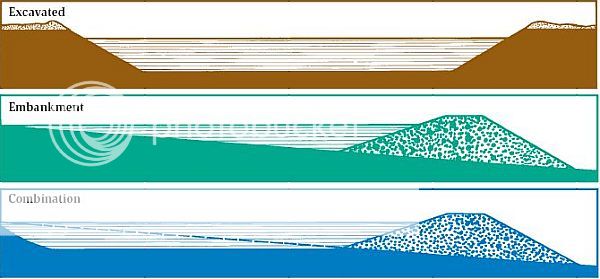
In West Virginia, most ponds are either excavated in which a depression is dug to retain water or are embankment ponds where a dam is constructed to retain water in a natural low area. Some ponds are also a combination of these two types of ponds. Most ponds are lined with local clay soil to assist in holding water in the pond. The colloidal particles of the clay swell with water and form an excellent liner.
Because of the topography and the way Lake William was constructed, it is not regularly shaped. However, it is roughly circular in shape.
As with all bodies of water, an important variable in supporting aquatic life is the dissolved oxygen available to organisms in the water. Generally, oxygen enters the water at the surface through diffusion. The more surface area a body of water has, the more oxygen that can diffuse into the water, all other variables (temperature, dissolved solids, water chemistry, etc) being equal. .
To claim this Earthcache please email the answers to the questions below to the cache owner prior to logging a find. Photos of Lake William or Barboursville Park are welcome. Logs with spoilers in the text or photos will be deleted without warning as will the logs of of cachers who have not emailed correct responses to the required questions.
- Set waypoints on opposite sides of Lake William then use the “measure” function of your GPSr to determine the distance across the lake in feet.
- Assuming that Lake William is circular in shape, use the distance you estimated in question 1 to calculate the surface area of Lake William in square feet.
- Since Lake William is a warm shallow lake with a small surface area and low oxygen level, what measures do you see at the lake to make the water better suited to the aquatic life and to the needs of the community.
- Use the image in the description of this Earthcache to determine whether Lake William is excavated, embankment or a combination of these.
This Earthcache is 100% handicap accessible and can be completed quickly and easily. However, please take the time to visit this beautiful park in Barboursville. Plenty of free parking is available as are picnic shelters, public bathrooms and recreational opportunities.
Special thanks to ScienceCacher for creating this Earthcache.