The Cliffs and Bluffs around this area of Southern California are some of the most beautiful and scenic in the world. The Formation that forms a lot of these Cliffs are also some of the most famous in the world. The Monterey Formation both helps form and hold a lot of Oil Deposits. Your kids may have asked you about this formation from school and it's the reason for those off shore oil rigs you see looking out towards the islands.

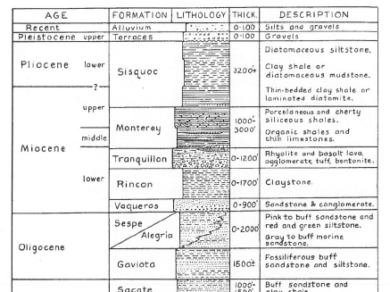
The Monterey Formation is made up mostly of hard shales, phosphatic shales (Microfossils in the shale that are only visible under electron microscope) and limestones. It also has large amounts of organic debris composed of microscopic plant and animal life.
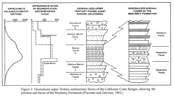
Monterey is fine-grained components (silica, carbonate and organic matter). These thin layers were largely deposited during an interval of Miocene warming. These sediments accumulated in Bathyal (deep water) depocenters (depositional basins). These bathyal environments were an oxygen-deficient environment.
Some of the strike slip faults in the area caused many fractures and within these you'll see calcite veins in some of the sea cliff exposures. The age of this Formation is Miocene approx. 5 million all the way to 23 million years ago. Over the years this Formation of jumbled rocks, broke, fractured, wrinkled and folded by tectonic shifts over millions of years trapped the marine life and organic matter and is rendered into oil through heat and pressure. The various seismic events have also helped this along.
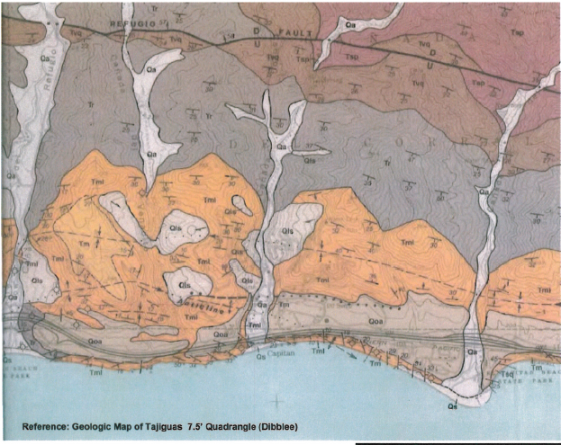
Tml is the Monterey Formation
The Monterey shale includes all the sediments lying above the Rincon Shale and below the Sisquoc formation. The boundary of the Monterey and Sisquoc formation can sometimes be seen along these cliffs as it goes from sedimentary to a thick layer of Conglomerate.
Logging Requirements: Please don't post pics of exact area, or answers on cache page
E-Mail me a note with:
1. The text "GC4V1NK Monterey at El Capitan"
2. How many people in your group today?
3. Do you see any tilt or angles of this Formation? What is the Tilt? or Angle?
4. Take a 3 foot section and count how many layers of rocks do you count?
5. In that 3 foot section, do you see two main colors? What are they?
6. Do you see any folds? If Yes describe them/it
The following Material were used for Reference:
- UCSB Geology Department
- U.S. Department of the Interior, Professional papers and Geological surveys
- California Parks.gov
- California Department of Conservation
- California Division of Mines and Geology, Geology report by T.W. Dibblee
- UC Davis Geology Department
- Wikipedia