Listing in serbian  and slovak
  language available below.
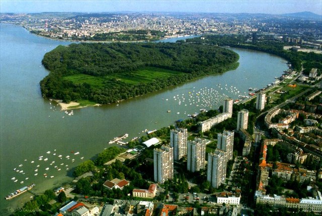
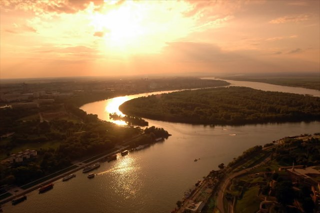
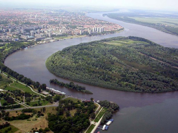
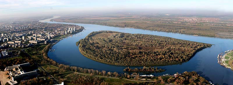
Great War Island - a phenomenon of wild environment in the middle of the big city.
Island gained its militant name because throughout the history Great War Island was an important strategic point either for the conquest or the defense of Belgrade. Turkish (1521) and Austria-Hungarian (1915) forces, used the island to launch their attacks against Belgrade.
Great War Island is protected natural area with three zones of protection: protection of nature zone, recreation zone and turism zone that includes the beach "Lido". Great and Little War Islands present the unique geological and morphological creation springing up from the underwather sandbank, with "emerged" during the 16th century. The surface layers of the island are alluvial sediment of the river Danube. The island is recognizable upon the unique community of flora and fauna. Swimimming beach Lido was arranged on the upstream tip of the Great War Island more than one hunderd years ago.
Geology:
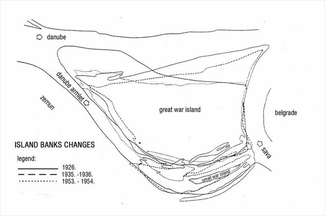
The geology of the island is very young, only about 500 years old and its shape is always changing. Rivers sediments are transported riverbed. In slowing its speed leads to their deposition and accumulation on the bottom. In the long process and the formation of the shallow swamps, which further slows down and change the flow of the river. It may create a new bank or island formed from sediments.This island is created based on a unique geological process, where the two big rivers (Danube and Sava) merge in the opposite direction of flow and dramatically slow their speed. Slowing down the river flow causes accumulation of alluvial sediments. This fact causes by the creation of island in this area. Sediments are predominantly from upper flow washed from the Alps and the Carpathians area. This material is so-called as "Danube sand" with a higher content of SiO2 and CaCO3. Great War Island is generally triangularly shaped and covers an area of 2.11 km². In the past was island several times completely disappeared, current island is there from the 16th century. It is low (the average altitude is 72m), for the most part marshy and often flooded by the Danube. In recent years only the coastal areas of island were flooded. The process of sedimentation is still not completed, therefore the shape of the island is still changing. So there is possibility of making a land connection to the bank of the Danube, because the island is relatively close to the banks.
On the south, halfway between the Great War Island and the city of Belgrade is the remnant of previously larger Little War Island. The main physical feature on the island is the canal of Veliki Galijaš. In time, the canal was cut off from the Danube and effectively turned into a lake, with an area of 0.24 km² and the major natural bird and fish spawning area on the island. During the droughty years the lake drains out completely causing damage to the closed eco-system centered around it. In 2007 the lake was connected to the Danube by the bioremediation.
Source: Wikipedia and info table on waipoint "INFO"
To log this cache, please send me answers to these questions:
- Which river sediments mostly created the island?
- Which river has at the confluence faster flow? This can be deduced from the position and shape of the island, and from the color of the water after confluence.
- (Optional) Estimate the distance from the river bank to the island near place of waypoint "INFO". CAUTION - This is variable, depending on the geological changes in the time and after the floods!
Please feel free to write log in your mother language, but please DO NOT put any spoilers via logs and photos, thanks!
See also the first Serbian EarthCache: Сићевачка клисура
 Serbia - If there are translation errors, please send a message to me via profile, with better translation in Cyrillic, thank you! (Извини за мој српски језик, нисам Србин)
Велико ратно острво - феномен дивље животне средине у сред великог града.
Острво добила име јер милитантни кроз историју Великог ратног острва јеважна стратешка тачка за било освајања или одбране Београда. Турски (1521) и Аустро-Угарске (1915) снаге, користи острво да покрене своје нападе против Београда.
Велико ратно острво је заштићено природно подручје са три зоне заштите: зона заштите природе, рекреативној зони и туризам зону која обухвата плажу "Лидо" Велики и мали рат Острва представити јединствену геолошку и морфолошку стварање ничу из ундерватхер спруду, са "појавила" током 16. века. Површински слојеви острву су алувијална седимент Дунава. Острво је препознатљив по јединственој заједници флоре и фауне. Плажа Лидо је уређен на узводном шпицу Великог ратног острва пре више од сто година .
Геологија :
Геологија на острву је веома млад, тек око 500 година, а његов облик се увек мења. Острво је креирана на основу јединственог геолошког процеса, где се две реке спајају у супротном смеру од тока и драматично успорити брзину. Успоравање тока реке изазива накупљање алувијалних седимената. Ова чињеница доводи до стварања острва у овој области. Седименти су претежно из горњег Дунава и да су опрали од Алпа и Карпата области. Овај материјал је тзв као "Дунав песак" са већим садржајем SiO2 и CaCO3. Велико ратно острво је генерално триангуларли облика и обухвата површину од 2,11 км². У прошлости је оток потпуно нестао неколико пута, струја острво је било од 16. века. То је низак (Просечна надморска висина је 72м ), највећим делом мочварно и често поплављена Дунава. У последњих неколико година само приобалним подручјима острва су поплављени. Процес таложења још увек није завршен, према томеоблик острва је и даље мења. Дакле, постоји могућност прављења копнена веза на обалу Дунава, јерострво је релативно близу обале.
На југу, на пола пута између Великог ратног острва и града Београда јеостатак претходно већег Малог Ратног острва. Основна физичка карактеристика на острву јеканал Велики Галијаш. Временом, канал је био одсечен од Дунава и ефикасно претворен у језеро, са површином од 0,24 км², анајвећи природни птица и риба мрести подручје на острву. Током сушна годинајезеро одводи у потпуности доводи до оштећења затвореном еко система центриран око ње. У 2007 језеро је повезан са Дунавом од биоремедијације.
Да бисте се пријавили овај кеш, пошаљите ми одговоре на ова питања:
- Који речних седимената углавном створио острво?
- Која река је на ушћу бржи проток? Ово се може извести из положају и облику острва, и од боје воде после ушћа.
- (Hеобавезан) Процена удаљености од обале на острву у близини места путање "Info"? ОПРЕЗ - Ово је променљива, у зависности од геолошких промена у времену и након поплава!
Slovakia
Velky vojensky ostrov – fenomen divociny uprostred velkomesta
Vojnove meno ostrova pochadza z historie, kedy ho turecke (1521) aj rakusko-uhorske (1915) vojska pouzili ako zakladnu pre obliehanie a utoky proti Belehradu. V novodobej historii, pravidelne pocas letnych sezon, budovala Juhoslovanska (a v sucasnosti Srbska) armada pontonovy most, ktory spaja ostrov s pravym brehom Dunaja.
Velky vojensky ostrov je chranene uzemie s troma zonami ochrany: chranene prirodne uzemie, rekreacna zona a turisticka zona s verejnou plazou Lido. Spolu s blizkym Malym vojenskym ostrovom vytvorili toto uzemie unikatne geologicke a morfologicke procesy, pohyby piesocneho dna a vodnych prudov.
Geologia:
Geologia ostrova je pomerne mlada, ma len priblizne 500 rokov a jeho tvar sa stale meni. Ostrov je vytvoreny unikatnym geologickym procesom na sutoku dvoch velkych riek - Dunaja a Savy. Rieky sa tu vlievaju do seba v opačnom smere toku - zrazaju sa v protismetre. To vyrazne spomaluje ich rychlost. Spomalenie toku rieky spôsobuje hromadenie naplavenin a sedimentov. Tato skutocnost spôsobila vytvorenie pevniny na tomto mieste. Sedimenty su prevazne z hornych tokov riek, donesene z Alpskej a Karpatskej oblasti. Povrchové vrstvy ostrova sú aluviálne sedimenty, tzv. "Dunajsky piesok" s vyssim obsahom SiO2 a CaCO3. Velky vojensky ostrov je priblizne trojuholnikoveho tvaru a ma rozlohu 2,11 km². V minulosti bol casto uplne zaplaveny pri povodniach, ktore vytvorili baziny na vychode ostrova. Po uprave horneho toku Dunaja su zaplavovane uz len okrajove casti ostrova. Zaujimavostou na ostrove je prirodny vodny kanal Veliki Gališ, ktory vzikol zaplavovou cinnostou. Neskor bol sedimentaciou od rieky odrezany a stal sa jazerom s unikatnym ekosystemom. Neskôr zaplavy opät sposobili jeho prepojenie s vodnym tokom a z jazera sa stal opät vodny kanal spojeny s riekou. Proces sedimentacie nie je dokonceny, preto sa tvar ostrova stale sa meni. Existuje moznost ze sa vytvori prirodne prepojenie ostrova s pevninou, pretoze ostrov je relativne blizko brehu.
Pre zalogovanie tejto EartCache mi poslite odpovede na nasledovne otazky:
- Zo sedimentov ktorej rieky je prevazne ostrov vytvoreny?
- Ktora rieka ma na sutoku rychlejsi prud? Je to mozne odvodit z polohy a tvaru ostrova, pôvodu sedimentov a farby vody za sutokom.
- (Nepovinne) Odhadnite sucasnu vzdialenost ostrova od brehu rieky na suradniciach waypointu "Info". Pozor - tato skutocnost sa moze casom menit, v zavislosti od geologickych zmien po zaplavach.
 The most exciting way to learn about the Earth and its processes is to get into the outdoors and experience it first-hand. Visiting an Earthcache is a great outdoor activity the whole family can enjoy. An Earthcache is a special place that people can visit to learn about a unique geoscience feature or aspect of our Earth. Earthcaches include a set of educational notes and the details about where to find the location (latitude and longitude). Visitors to Earthcaches can see how our planet has been shaped by geological processes, how we manage the resources and how scientists gather evidence to learn about the Earth. To find out more click HERE.