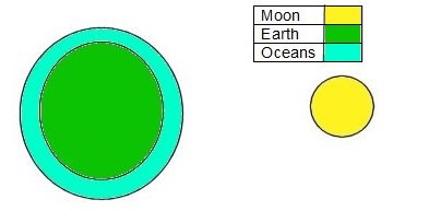
Tides – what are they all about? If you describe them to someone who’s not used to being around the sea they will laugh at you. The sea comes up the beach? On its own? To (pretty much) the same point and then over the next few hours recedes several yards? To pretty much the same point? And then it comes back again? And it does this constantly? As a native of a seaside town I have lost count of how many times I have told “in-land-ers” about tides. And I have lost count of how many times I have taken people to beaches and returned a few hours later to prove that the sea does indeed move up and down the beach seemingly of its own volition. But how does this happen? It’s all to do with the Moon. Imagine if you will the Moon in its orbit around the Earth. .
 ........
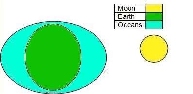
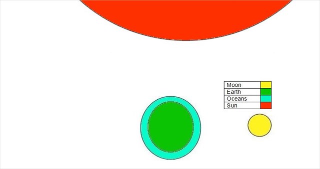
The Moon’s gravity pulls on the Earth, much as the Earth’s gravity pulls on the Moon. Because water flows more easily than anything solid, the water actually bulges out. The diagram below is extremely exaggerated, but in principle this is what happens:
 ........
So at any given time sea level is measurably higher at one point on Earth than it is in another.
 ........
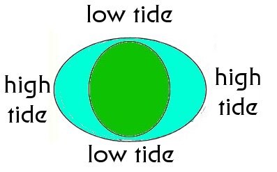
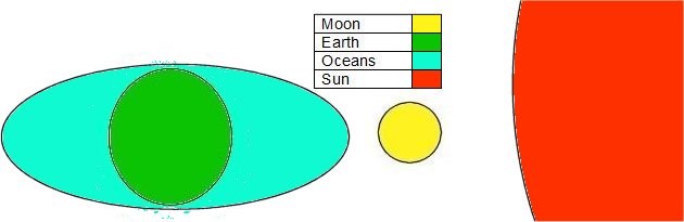
Now bear in mind that the Earth is spinning. It takes one day to spin once. And as it spins it spins through an ocean of water which is bulging toward the moon So imagine you are at a point on the Earth where it is high tide with the Moon overhead. As the Earth spins you will move away from the area of high tide into one of low tide, then into another high tide area (where you cannot see the Moon as it is on the other side of the Earth), and then through another low tide back to having the Moon overhead one day later than when you started. One day…? No. Not exactly. There is an added complication… the Moon is not fixed in space. It orbits the Earth once every twenty eight (and a bit) days. Therefore rather than having tides on a twenty-four hour cycle we have tides (at Dungeness) we have a cycle which is slightly more than twenty four hours long. And there is another complication. The Moon isn’t the only gravitational influence on the oceans. The Sun has far greater gravity than the Moon, but is much further away. But it too has an effect. Therefore when the Sun and Moon are in alignment we get much longer tides. These are known as ”Spring tides”
 ........
Obviously the diagram isn’t drawn to scale !! Similarly when the Sun and the Moon are in opposition we get much shorter tides – “Neap tides”
 ........
So there we are. Easy enough so far. But let’s now actually go to the beach. Or two beaches and we will look at tides in action. Here we will see that the shape of the shore and the prevailing winds and currents can also have an effect on the tides. Also look at the waves which are independent of the tides. To qualify for this cache this is what you have to do: Have a look at this website http://www.tidetimes.org.uk/dungeness-tide-times , or look up the tides (tide tables are easily available) and be at the co-ordinates for this cache (Greatstone Beach car park) one hour before low tide. Allow yourself two hours to do these tasks. It won’t take two hours; there are other caches to do nearby as a time filler.
Walk onto the beach at Greatstone (the co-ords for this Earthcache) and find the high water mark. It will be easily identifiable as a line of seaweed, flotsam, jetsam and all sorts of stuff which gets washed up. Use your GPS device to measure the distance from here to the sea. Both in horizontal and vertical distance. How far is it as the crow flies? How far up or down have you gone? And look at the beach. Describe it, and make a mental note of the appearence of the waves.
Done that? Go caching for an hour or so then make your way to the second location; the car park near the power station (waymarked) and walk to the beach one hour after low tide. We are going to assume that the tide comes in and goes out at the same rate. Does it?
Again find the high water mark. It will be easily identifiable as a line of seaweed, flotsam, jetsam and all sorts of stuff which gets washed up. Use your GPS device to measure the distance from here to the sea. Both in horizontal and vertical distance. How far is it as the crow flies? How far up or down have you gone?.
Look at the beach. Describe it. How does it differ from Greatstone Beach? How does the waves here differ from what you saw at Greatstone beach? Compare the distances you’ve just measured with the distances you measured at Greatstone. Are they much the same?
Can you account for any differences?.
You might wish to append photos of your day to your log. As always you are welcome to do so, but doing so is entirely optional. It would be nice however if you did put the time of the low tide you investigated in your log
