Gorges du Verdon Multi-cache
-
Difficulty:
-

-
Terrain:
-

Size:  (small)
Please note Use of geocaching.com services is subject to the terms and conditions
in our disclaimer.
|
Gorges du Verdon
|
|
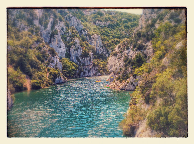
[FR:] Cette promenade (début jusqu’à la fin ~ 3 km) près des gorges du Verdon vous montre différentes perspectives et vues sur cette jolie rivière. Faites attention où vous mettez vos pieds! Même si vous restez sur les chemins officiels il y a des parties un peu dangereuses.
A chaque station il faut noter l’altitude (Alt). Ces valeurs sont nécessaires pour le calcul des coordonnées finales.
Le chemin vous amène à un bel endroit, duquel vous avez une vue magnifique sur le Verdon.
Le point finale est ici : N 43° 41.(B + C + 79) E 006° (A + B + C - 200)
Bonne promenade!
|
|
[DE:] Euch erwartet eine kleine Wanderung (Startpunkt bis Finallocation ~ 3 km) entlang der Gorges du Verdon. Die Wegstrecke ist teilweise sehr steil und führt euch an Plätzen vorbei, an denen ihr den Verdon aus verschiedenen Perspektiven sehen könnt. Bitte achtet darauf wo ihr hintretet! Auch wenn ihr euch die ganze Zeit auf offiziellen Wanderwegen bewegt, ist es hier teilweise nicht ganz ungefährlich.
An jeder Station müsst ihr die Alt(itude) ablesen und notieren. Diese Werte werden für die Finalberechnung benötigt.
Der lange Anstieg wird schließlich mit einer Dose und einem wunderschönen Ausblick belohnt.
Das Final findet ihr hier: N 43° 41.(B + C + 79) E 006° (A + B + C - 200)
Viel Spaß!
|
|
[EN:] You can expect a hike (starting point to final location ~ 3 km) along the Gorges du Verdon. The trail is very steep and leads you past places where you can see the Verdon from different perspectives. Be careful of your step! Even if you are on an official hiking trail there are dangerous parts.
At each station you have to note the Alt(itude). These values are needed for the final calculation.
The long ascent is finally rewarded with a cache and a beautiful view.
The final can be found here: N 43° 41.(B + C + 79) E 006° (A + B + C - 200)
Enjoy the hike!
|
Additional Hints
(Decrypt)
[FR:] Hgvyvfrm yn cubgb "fcbvyre".
[DE:] Orahgmg qnf Fcbvyre-Ovyq.
[EN:] Hfr gur Fcbvyre-Cvpgher.