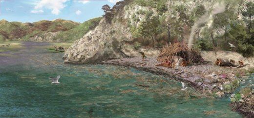
Le site de Terra Amata se trouve en plein cœur de la ville de Nice, sur les pentes occidentales du Mont Boron, à 300 mètres du port. Il y a 400 000 ans, à cet emplacement, s’étendait une plage de galets. Le climat était alors plus chaud que de nos jours.
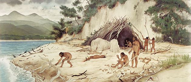
Cette plage fossile se trouve aujourd’hui à 26 mètres au-dessus du niveau actuel de la mer. Le site nous prouve donc qu’il y a 400 000 ans, la mer atteignait encore cette altitude. Un peu plus loin, au Sud-Est du site, la mer travaillait à l’élargissement d’une grotte littorale : la grotte du Lazaret. Elle y a également déposé ses galets et ses sables. Comme le montrent les planches à l’étage du musée, une grande partie de la plaine littorale de Nice était alors submergée. Dans le vaste delta formé par l’embouchure du Paillon, le rocher du Château était alors… une île !
Les sédiments quaternaires de Terra Amata atteignent 15 mètres d’épaisseur. Ils reposent sur un socle de calcaires et de marnes datant du Secondaire (ère géologique de -251 à -65,5 millions d’années).
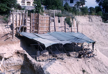 La plage de Terra Amata représente aussi un site archéologie de grand intérêt. Les fouilles archéologiques entreprises en 1966 ont mis à jour des emplacements de huttes, qui apportèrent de nouvelles connaissances sur le mode de vie des Homo erectus. Le musée est inauguré le 16 septembre 1976, au rez-de-chaussée de l’immeuble qui remplace aujourd’hui la plage, découverte en 1966.
La grande salle au rez-de-chaussée du musée présente un moulage de 60m². Il permet d’observer l’un des sols d’habitat tel qu’il a été trouvé à Terra Amata. Ce sol est établi sur une petite dune de sable, et est caractérisé par la présence d’un foyer protégé des vents dominants par une petite structure de sable et de galets. De nombreux matériels archéologiques et géologiques d’intérêt y sont retrouvés.
ATTENTION, les informations pour pouvoir valider la cache se trouvent dans le musée, il faut donc la faire pendant les horaires d’ouverture. L'accès au musée est de 10€ pour les adultes, gratuit pour les enfants et les habitants de Nice Métropole.
Horaires d'ouverture :
Du mercredi au dimanche : 10h00 - 18h00
Fermé les mardis et certains jours fériés (Noël, 1er janvier, dimanche de Pâques et 1er mai).
Les lundis sont réservés aux visites de groupes.
Earthcache :
Afin de valider cette Earthcache, merci de m'envoyer vos réponses par mail.
- Dans la carotte sédimentaire du sol fossile, quelle est l’épaisseur de la croûte calcaire ? (en cm)
- Sur la reconstitution de la plage, quel os d’animal est mis en évidence sur le panneau d’information ?
- Quel est le nom du sol d’habitat de Terra Amata ? Réponse de la forme : "Sol **"
- Si possible, postez dans votre log une photo de vous ou votre GPS devant la reconstitution de la plage !
Beach of Terra Amata
The site of Terra Amata is located in the heart of Nice, along the western slopes of Mount Boron, 300 meters away from the port. 400 000 years ago, this place was made of a long beach of pebbles. The climate was then warmer than today.
Today, this fossilized beach is 26 meters above the current sea level. This site proves that 400 000 years ago, the sea was still at this level. A little further in South-East of this site, the sea was already working on the enlargement of a coastal cave, the C.ave of Le Lazaret. This cave also received pebbles and sands from the sea. As you can see on the illustrations on first floor, a large part of the coastal plains of Nice was under the water at that time. In this wide delta of the mouth of Paillon, the rock of the Castle was then… an island!
The quaternary sediments of Terra Amata are 15 meters thick. They rest upon a ground made of limestone and marls, dating from the Mesozoic (geological era from -251 to -65.5 million years).
The beach of Terra Amata also represents a major archaeological site. The archaeological excavations that were done in 1966 have highlighted the locations of huts, which improved the knowledge about the life style of Homo erectus. The museum was opened on September 16, 1976. It is located on the ground floor of the building that stands today on the exact location of the site, discovered in 1966.
The large room on the ground floor of the museum presents a 60 m² molding. It stands for one of the housing ground as it was discovered in Terra Amata. This ground was established on a small sand dune, and is characterized by the presence of a fire place, protected of the winds by a little structure made of sand and pebbles. Many archaeological and geological materials can be found along this ground.
BE CAREFUL, the information for validating this cache are inside the museum. The entrance is 10€ per adult, and free for children and people from Nice. Take care of coming here during the opening period.
Opening hours:
Wednesday to Sunday: 10am – 6pm
Closed on Tuesdays and a few holidays: Christmas, January 1st, Easter Sunday, May 1st.
Mondays are only for groups.
Earthcache:
In order to validate this Earthcache, please answer this questions and send me your answers by mail.
- In the sediment core ("carotte") of the fossilized ground, what is the thickness of the limestone crust ("croute calcaire") ? (centimeters)
- On the beach molding, which animal’s bone is highlighted? (information panel)
- What is the name of the housing ground ("sol d'habitat") of Terra Amata? Answer is in the form of "Sol **"
- If possible, it will be great to have a picture of you or your GPS in front of the beach molding!