Per arrivare a GZ, che si trova fuori le mure, bisogna scendere la strada ripida dal "trailhead" e dopo la porta, girare a destra.
To get to GZ, which is outside the walls, head down the steep road from the trailhead, through the gate & turn right.
Domande / Questions
ITA: Alle coordinate, si vedono i due tipi di roccia principali, e in mezzo alcuni mattoni che fanno parte della Porta Soliana. Per prendere questa cache, dovete mandarci per e-mail le risposte alle seguenti domande. Leggete l’informazione che segue per aiutarvi!
- Che tipo di roccia vulcanica si vede alla sinistra dei mattoni?
- Qual’ altro tipo si vede a destra?
- Quale prova si vede che indica l’origine vulcanica di queste rocce?
- Descrivete le rocce e la loro struttura.
- Com’è possibile sapere che queste rocce vulcaniche sono il produtto di un flusso piroclastico e non di una colata di lava? (Pensate al tipo di roccie formato dalle colate di lava – qual’è la differenza?)
Per favore, NON affiggiate o le risposte o delle foto che mostrano le risposte, comunque qualsiasi altre foto dalla visita sono i benvenuti
ENG: At the co-ordinates, you can see both main types of volcanic rock, and in between, some bricks built into the cliff, part of the Porta Soliana. To claim this earthcache, please email us the answers to the following questions. Reading the information below will help!
- What type of volcanic rock is clearly visible to the left of the bricks?
- What other type of rock can you see on the right?
- What evidence can you see that indicates the volcanic origin of these rocks?
- Briefly describe these rocks and their texture.
- How can you tell these volcanic rocks are the product of a pyroclastic flow, not a lava flow? (Think about the kinds of rock that are formed in lava flows – what is the difference?)
Please do NOT post the answers in your log, or upload photos showing the answers, but other photos from your visit are definitely welcome!
Geologia e Storia Breve / Geology & Brief History
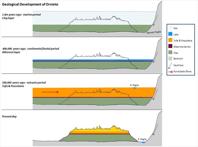
ITA: Nella prima parte del periodo quaternario, circa 1.800.000 anni fa, la terra di Orvieto era un’ambiente marino, con della sedimentazione delle argille plioceniche ed arenarie coperto dal mare. Nel corso dei prossimi 1.5 millioni d’anni, la mare si ritirò, lasciando dietro un lago. Sopra l’argilla, c’era uno strato sottile di sabbie, conglomerati, limi e pomici - “le serie dell’Albornoz”, così detto perchè questo strato si vede meglio alla fortezza del cardinale Albornoz (XIV secolo).
Circa 100.000 anni fa, il lago si seccò ed i vulcani Volsini erano molto attivi; il lago di Bolsena è un cratere creato in questo periodo. La terra in questa zona era adesso coperta di un altopiano di roccia vulcanica: in prevalenza dei tufi creati dei flussi piroclastichi. Questi si raffreddarono velocemente, che si manifesta attualmente nelle fessure verticali (fratturazione in colonne). Mescolato nei tufi, ci sono anche delle “pozzolane”, rocce friabili di cenere vulcanica. Tutte e due sono porose, e si disgregavano (provocato dai tributari dal fiume Paglia e dagli agenti atmosferici) fino a far creare il profilo della rupe che si vede oggi. La rupe è sempre instabile e succedono delle frane – ma è stata colonizzata da 3.000 anni.
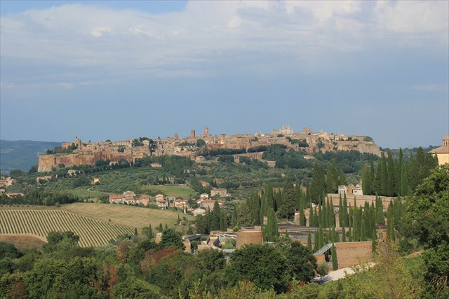
La città risale all’epoca etrusca - il periodo più importante era dal VI al IV secolo a.C. Nel medioevo, grazie alla sua geologia, l’importanza strategica della rupe come fortezza è stata riconosciuta dalla chiesa e dalle famiglie nobili, che hanno costruito la città come si vede oggi. I mattoni medievali che sono stati utilizzati nella costruzione di molti edifici e che il visitore può vedere dappertutto, erano realizzati dal tufo, e si serviva dalla pozzolana come cemento. Grazie alla sua origine vulcanica, la pozzolana mischiata con la calce crea un cemento che diventa solido anche sotto acqua, un fato nota dai antichi romani. Sotto le case e chiese, si trovano 1.200 grotte circa, le più anziane sono etrusche che incorporano pozze che scendono 80m fino al livello dell’acqua. Le grotte sono state utilizzate anche per diverse attività, per esempio miniere di pozzolano, mulino di olive, conservo d’alimento, cura dei piccioni, produzione di ceramiche e corde, e che permetteva agli abitanti di sopravivere nei periodi di assedio.
Si può fare la visita ad alcune grotte (a pagamento) ed anche fare una passegiata sul percorso pedonale, l’anello della rupe, dove vi trovate adesso.
Buon divertimento! 
ENG: In the early part of the Quaternary Period, about 1.8 million years ago, the land where Orvieto is located was a mixture of soft Pliocene clays, covered by the sea. Over the course of the next 1.5 million years, the sea retreated, leaving behind a lake. Still underwater, the clay was now covered by a thin layer of fluvial deposits; sand, conglomerate and some volcanic material known as the “Albornoz Series”, named for the XIV century Cardinal Albornoz whose fort is located where this layer is best seen.
By 100,000 years ago, the lake had dried up, and the land was covered by volcanic rock as a consequence of the activity of the volcanoes in the Vulsini mountains, which also created the crater lake of Bolsena. This rock was a plateau of predominantly tufa, created by pyroclastic flows which cooled quickly, as evidenced by visible vertical fissures (“columnar fracturing”). Also mixed in with the tufa, is a rock consisting of friable volcanic ash that is referred to locally as “pozzolana”. Both are extremely porous, and over time, the surrounding area has been eroded, by tributaries of the river Paglia and from weathering, to give the profile we see today; still unstable and subject to landslides, but which has nevertheless withstood 3000 years of human civilisation.
The city itself is of Etruscan origin, this first settlement was at its peak between the 6th and 4th centuries BC. Then during the early middle ages, the strategic importance of the cliff as a natural fortress, thanks to its geological structure, led to a new development which resulted in the medieval city much as we see it today. The bricks that were used in the construction of many buildings and easily noticed by visitors to the city, were made from tufa, with pozzolana used as cement. Due to its volcanic origins, pozzalana when mixed with lime, forms a concrete than can set even under water, a fact known to ancient Romans. Below the city are about 1200 caves, the oldest incorporating Etruscan wells, which extend down 80m through the tufa to the water table at the level of the clay. Later medieval caves were used for a wider range of activities – small pozzolana quarries, oil mills, food storage, pigeon keeping, potteries & rope making etc – all of which proved essential in times of siege.
Nowadays it is possible to visit some of the caves (entrance fee payable) and also to walk round the cliffs: where you are now standing is part of this path, the “Anello della rupe” which forms a complete circuit of the city.
Enjoy your visit!
Parcheggio / Parking
ITA: Il parcheggio più vicino si trova a Piazza Cahen (waypoint), ce ne sono altri nella città, ma anche alla stazione ferroviaria in basso. Il funicolare della stazione arriva a Piazza Cahen. State attenti del pavimento ripido dal trailhead alla cache!
ENG: The closest is Piazza Cahen (waypoint), there are others around the edge of the city, or lower down eg at the railway station. The funicular from the station arrives in Piazza Cahen. Please note the route from the trailhead to the cache is paved, but steep.
http://www.inorvieto.it/it/organizza/parcheggi_e_mobilita.html