The River Neath (Welsh = Afon Nedd) is a river in South Wales. running south west from its source in the Brecon Beacons National Park to its mouth at Baglan Bay below Briton Ferry on the east side of Swansea Bay
The river flows through the Vale of Neath, a long straight valley developed along the Neath Disturbance and which carried a major glacier during the ice ages.
The estuary of the River Neath extends from Neath town down past Briton Ferry to the sea next to Jersey Marine Beach. The estuary is partly industrialised with a former ship breaking yard, large local authority sites and wharves at Melincryddan.

Above is an aerial view of the estuary, to either side, where it remains undisturbed, there are areas of salt marsh stretching from Neath to Baglan Bay and Crymlyn Burrows. They are of great ecological value.
The tidal range is the vertical difference between the high tide and the succeeding low tide
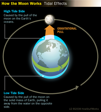
Tides are the rise and fall of sea levels caused by the combined effects of the gravitational forces exerted by the Moon and the Sun and the rotation of the Earth. The tidal range is not constant, but changes depending on where the sun and the moon are.
The most extreme tidal range occurs around the time of the full or new moons, when the gravitational forces of both the Sun and Moon are in phase, reinforcing each other in the same direction, or are exactly the opposite phase
This type of tide is known as a spring tide. During neap tides, when the Moon and Sun's gravitational force vectors act in quadrature (making a right angle to the Earth's orbit), the difference between high and low tides is smaller.
Neap tides occur during the first and last quarters of the moon's phases. The largest annual tidal range can be expected around the time of the equinox, if coincidental with a spring tide.
The typical tidal range in the open ocean is about 0.6 metres (2 feet). Closer to the coast, this range is much greater. Coastal tidal ranges vary globally and can differ anywhere from near zero to over 11 metres (38 feet).
The exact range depends on the volume of water adjacent to the coast, and the geography of the basin the water sits in. Larger bodies of water have higher ranges, and the geography can act as a funnel amplifying or dispersing the tide.
The world's largest tidal range of 11.7 metres (38.4 feet) occurs at Burntcoat Head in the Bay of Fundy, Eastern Canada. Below is a picture of the Neath River at high tide.

Seawalls are important features of urbanised harbours. They are built for many reasons, e.g. to prevent the collapse of soft banks, or to provide access to the shore for boats. Seawalls also add new "hard" substrata on which marine animals and plants can live. There can be a great profusion of seaweeds and attached (oysters, mussels) and mobile (snails, starfish, sea urchins) animals on seawalls, especially below low tide. Although the intertidal area on seawalls is not very large, it contains a diversity of marine life.
Seawalls differ from natural rocky shores in important ways. First, around Sydney, they tend to be steep, often vertical. Second, seawalls have fewer cracks, crevices and overhangs compared to rocky shores and some habitats (e.g. rock pools) are completely missing. Local councils spend a lot of money filling in cracks and holes in seawalls - for aesthetic reasons as well as safety. This has the potential to remove complex habitats that might be very important for the survival of many intertidal organisms, particularly those that depend on holes and crevices.
Shoreline structures like this installation can directly encroach on the intertidal zone from a landward direction, leading to a physical reduction in intertidal area and disturbance to the physical, biological and chemical structure of the immediate area. In addition, these structures can prevent the intertidal zone moving landward in response to wider coastal changes, causing coastal squeeze and a reduction in intertidal area.
You can find a useful tidetable at this link
http://www.bbc.co.uk/weather/coast_and_sea/tide_tables/11/509#tide-details
EARTHCACHES ARE DESIGNED AS AN OUTSIDE ACTIVITY, YOU DO HAVE TO GO OUTDOORS TO COMPLETE IT!
Getting to the earthcache site
Directions from the WEST
Leave the M4 motorway at Jct.42 signed A48 Briton Ferry. At the signs bear left on to the A48 At the roundabout take the 4th exit on to Brunel Way. Parking is available in a lay-by opposite the white wind turbine
Directions from the EAST
Leave the M4 at Jct. 41 signed Briton Ferry. Follow the slip road to the roundabout. At the round about take the second exiton to the A48 At the next roundabout take the 1st exit on to Brunel Way. Parking is available in a lay-by opposite the white wind turbine
Look towards the river and you will see the Wales Coastal Path follow this to the coordinates provided.
THERE IS A SERIOUS RISK OF FALLING OFF THE WHARF
THERE IS NO BARRIER ........... PLEASE TAKE EXTREME CARE
Please EMAIL me the answers
~ From the guidelines: You do not need to wait for permission to log.
~ Requiring you to wait is not supported by the Earthcache guidelines.
~You should SEND your logging task answers, then LOG the Earthcache.
~IF YOU DO NOT COMPLETE THE LOGGING TASK YOU LOG WILL BE DELETED WITHOUT NOTICE
LOGGING TASKS
1. Use a tide table to plan you visit when the tide is as LOW. Tell me when you visited.
2. Carefully look down. Estimate how far down from the top of the wharf is the EXPOSED river bed?
3. In a perfect world you would come back at high tide. However please DETAIL any physical evidence on the wall which suggests how high up the water rises? THIS THE TIDAL RANGE
4. Estimate the rise form the evidence you described.
5. How have natural processes been impacted by the man made structure you are standing on?
AND JUST TO CHECK THAT YOU DID GET OUTDOORS!
6. How many bollards for mooring boats are there on the concrete wharf, and are they all metal or (b) metal + another material (please identify)?
By all means post photos BUT please do not include any answers in your log or post photos THAT WOULD GIVE OTHERS THE ANSWER!!!