Maankohoaminen on geologinen ilmiö alueilla, jotka aikoinaan olivat mannerjäätiköiden peitossa. Viimeisen jääkauden kylmimmän vaiheen aikana 18 000–20 000 vuotta sitten Skandinavian mannerjäätikkö oli laajimmillaan ulottuen Pohjolasta aina Keski-Eurooppaan asti. Vuosituhansien aikana valtava, jopa kilometrien paksuinen jäämassa painoi alla olleen maankuoren lommolle. Mannerjäätikön sulaminen ja oheneminen käynnistivät maankohoamisen, joka onkin maankuoren hidasta palautumista jäätiköitymistä edeltäneeseen muotoonsa.
Jäätikön häviämistä seuranneen ensimmäisen vuosituhannen aikana maankohoaminen oli yli kymmenen kertaa suurempaa kuin nykyisin, nopeimmin kohonneilla alueilla jopa yli kymmenen metriä sadassa vuodessa. Sen jälkeen kohoaminen on koko ajan hidastunut. Nykyisin maa kohoaa Saaristomerellä noin neljäkymmentä senttimetriä sadassa vuodessa.
Maankohoamisen myötä vedenalaiset karit ja särkät nousevat näkyville ja matalat merenlahdet kuroutuvat merestä makeavetisiksi altaiksi. Aluksi nämä ruovikkorantaiset merenlahdet ovat vielä osa merta ja niitä kutsutaan fladoiksi. Maankohoamisen jatkuessa fladat kuroutuvat kokonaan irti merestä ja muuttuvat vähitellen makeavetisiksi glo-järviksi. Maankohoamisrannikoiden glo-järvet ovat maailmanlaajuisesti ajatellen ainutlaatuisia elinympäristöjä, ja Itämeren murtovesiympäristö lisää niiden suojeluarvoa edelleen.
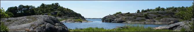
Yxskärin saarella on oma fladansa ja glo-järvensä, jotka tämä geokohde esittelee kuljettaen kävijänsä saaren luontopolun kautta. Polun varrelta aukeaa lisäksi upeita saaristonäköaloja, ja kesäisin sen varrella on mahdollisuus kohdata saarella laiduntavia lehmiä ja lampaita. Maastoon selkeästi merkityn polun pituus on n. 800 metriä.
Tehtävät
Geokohteen löydetyksi loggaaminen edellyttää vierailemista kätkökoordinaattien tuntumassa ja vastaamista vierailun perusteella seuraaviin kysymyksiin. Lähetä vastauksesi kätkön tekijälle tästä.
1. Kuvaile maaperän rakennetta ja sen suhdetta vedenpintaan Yxskärin glo-järven ja fladan välissä. Onko glo-järvi ollut jo pitkään erillinen fladasta? Mihin perustat päätelmäsi?
2. Mitä glo-järvelle tapahtuu maankohoamisen jatkuessa edelleen? Entä fladalle?
3. Ota kuva itsestäsi luontopolun varrella ja liitä se loggaukseesi. Tämä tehtävä on vapaaehtoinen.
Voit logata kätkön heti lähetettyäsi vastaukset. Ethän spoilaa vastauksia loggauksessasi tai siihen liittämissäsi kuvissa.
Post-glacial rebound is a geological process taking place in regions that have been covered by glacial ice sheets. During the last glacial period's maximum, 18,000-20,000 years ago, the Scandinavian ice sheet reached as far south as Central Europe. The enormous weight of the ice pressed the surface of the Earth's crust for millennia, causing it to deform and warp downward. When the glaciers retreated at the end of the glacial period, the removal of the weight led to the slow rebound of the land to its pre-glacial form.
During the first millennium after the glacial period, the speed of the rebound was over ten times faster than today, at some places even more than ten meters in a hundred years. Since then, the process has slowed down, and today, land in the Archipelago National Park rises at the pace of forty centimeters in a hundred years.
The slow upthrust of the Earth's crust causes underwater rocks and reefs to rise above the water, and shallow bays to slowly become separated from the sea, forming sweet water basins. At first, these reedy bays are still connected to the sea and are called fladas; but eventually, the rising of the land separates them from the sea and turns them into sweet water lakes called glos.
The nature trail on the island of Yxskär takes the traveller on a route which visits both landforms, a flada and a glo, and also offers spectacular views over the archipelago. In summertime, cows and sheep grazing on the island are likely to be met. The length of the trail is 800 meters.
Tasks
Logging this Earthcache as found requires a visit to the vicinity of the cache coordinates, and based on the visit, answering the following questions. Please send your answers to the owner of this cache using this link.
1. Describe the structure of the ground and its relation to the water level at the site between the glo lake and the flada. Has the glo lake been separated from the flada for a long period of time? How did you draw this conclusion?
2. What will happen to the glo lake as the post-glacial rebound continues? How about the flada?
3. Optionally, post photos of yourself on the nature trail with your log.
You may log the cache as found as soon as the answers have been sent. Please do not spoil the answers in your log.
Lähteet/Sources:
Peter Johansson: Maa kohoaa. Geologian tutkimuskeskus (2009).
Yxskärin luontopolun infotaulut / Info tables on the nature trail of Yxskär.