[FI]
Viime jääkauden aikana pohjoismaita peitti valtava ja erittäin suuri jäätikkö. Jäätikön paino oli niin suuri, että se painoi maanpintaa alaspäin useita metrejä. Kun jääkauden päättymisen myötä jäätikkö suli alueelta pois, maa alkoi kohota entiselleen.
Jäätikön sulamisvedet muodostivat aluksi erittäin suuren meren. Maankohoamisen takia sulamisveden muodostama valtava pinta-ala supistui jatkuvasti, sillä maa nousi koko ajan korkeammaksi ja korkeammaksi. Tunnettuja kehitysvaiheita nykyiselle Itämerelle ovat Baltian jääjärvi, Yoldiameri, Ancylusjärvi ja Litorinameri.
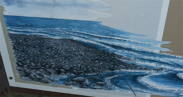
Noin 4000 vuotta sitten Öjbergetin alue oli pieni, yksinäinen saari keskellä läntistä merta. Saaren ympärillä oli tyrskyistä merta, sillä siihen aikaan ei ollut vielä muita saaria, jotka olisivat tyrskyiltä suojanneet. Aallot huuhtoivat kaiken hiekan ja soran rannoilta pois, jättäen rannalle vain kiviä. Kivet painautuivat toisiaan vasten, samalla hioutuen pyöreähköiksi.
Nykyään, 4000 vuotta myöhemmin, Öjberget on suosittu kukkula Vaasassa. Menneestä ajasta meillä on 60 metrin korkeudessa nykyisestä merenpinnasta muistona muinaisen saaren rantakivikko, jota myös pirunpelloksi kutsutaan. Nimitys on peräisin ajalta, jolloin ihmiset uskoivat itse pirun viljelleen alueella kiviä.
[EN]
During the last ice age there was a huge glacier which covered Nordic countries. The weight of the ice was so big that it pushed the soil down for many meters. When the ice age ended and the ice melted, the soil started to rise back to its original situation.
Melted ice formed a huge sea. Because of the landrising this area of water was going smaller and smaller because the land was even higher and higher all the time. The best known stages of the Baltic Sea nowadays are Baltic Ice Lake, Yoldia Sea, Ancylus Lake and Litorina Sea.
About 4000 years ago the area of Öjberget was a small lonely island in the middle of the western sea. The island was surrounded by easily storming sea. That time there wasn’t any other islands, which would have covered Öjberget from the waves. The waves washed all the sand and gravel away, leaving only the rocks. The rocks pushed side by side and they got honed, so they are roundish nowadays.
Now, 4000 years later, Öjberget is popular hill in Vaasa. Our memory from the past is an ancient shoreline of this ancient island, which is also called as a Devil’s field. This tittle is from the time when people believed that the devil himself was farming rocks.
Logging
[FI]
1. Mene annettujen koordinaattien osoittamalle paikalle. Tutki ja ihastele aluetta, tutkiessasi aluetta päättele, mistä suunnasta aallot ovat todennäköisesti rantaan osuneet. (Missä suunnassa meri olisi voinut olla, jos tämä oli ranta.) Anna vastaukselle perusteluja, niin näen että olet oikeasti miettinyt asiaa. Tärkeintä ei ole oikea ratkaisu vaan ympäristön käyttö päättelyssä!
2. Maankohoaminen ei ole pysähtynyt, vaan sitä tapahtuu edelleen. Mikä on todennäköisesti Vaasan kaupungin tulevaisuus rannikkokaupunkina?
3. VAIHTOEHTOINEN Ota itsestäsi kuva alueella ja liitä se logiisi. Älä kuitenkaan anna kuvassa mitään spoilaavaa tietoa. Kuvan otto voi helpottaa tarkistusta, jos olen vastaustesi takia kahden vaiheilla siitä, oletko paikalla käynyt. Toki vastausten pitää olla huolella tehtyjä ja suunnilleen oikeita.
Lähetä vastaukset minulle yksityisviestinä profiilini kautta. Sinun ei tarvitse odottaa loggauslupaa, vastailen sitten jos on jotain epäselvyyksiä.
[EN]
1. Go to the given coordinates. Explore and enjoy the view of the area. While exploring try to figure out the direction where the waves came from during the ancient time. (The direction where the ancient sea could have been if this area was the beach.) Tell me also how did you came up with this kind of decision, so it is easier to me to undestand that you have really thought about it. Right solution isn't the most important thing, using the area as your help is.
2. The landrising has not stopped. What do you think is likely going to happen to Vaasa as it nowadays is a coast town?
3. OPTIONAL Take a picture of yourself at the area and put it into your log. The picture musn't give any spoiling information. Taking a photo can help me if I'm a bit unconfident that you have actually visited the area because of your answers. Of course the answers have to be made carefully and about correct.
Send the answers to me as a private message. You don't have to wait a permission to log, I'll answer to you if I there is some obscurities!
Du kan också skicka dina svarorna på svenska, om du vill, men jag kan svara på finska eller engelska.