Strike and Dip in Hyde Park EarthCache
Strike and Dip in Hyde Park
-
Difficulty:
-

-
Terrain:
-
Size:  (other)
Please note Use of geocaching.com services is subject to the terms and conditions
in our disclaimer.
From the shores of Long Island to the Adirondack Mountains to Lake Ontario, the rocks of New York State tell a tale of a fascinating geologic history. The rocks of the Hudson valley area demonstrate a tale of inland seas and massive mountain building events. This earthcache gives you an opportunity to take a few measurements on how these events sculpted this area.
Approximately 600 - 700 million years ago the North American continent developed a rift (a tear in the earth’s crust that continuously erupts magma and pushes the two sides apart) and began splitting apart, each side moving in the opposite direction of the other. As this occurred the area between the two land masses filled with sediments and volcanic deposits (from the magma at the rift zone). Over time sea level rose and much of New York was covered by this ancient shallow sea known as the Iapetus Ocean.
When the rifting ended, the ancient sea began to close and our continent collided with the island arc that had developed during the rifting process. This event is called the Taconic Orogeny (or mountain building event). During this event the sedimentary deposits that made up the shorelines were scraped off and thrust onto the continent as the rest of the mass was forced deep into the
earth. Following the Taconic Orogeny was the Acadian Orogeny which occurred roughly 400 million years ago. These tectonic events altered the landscape through active folding and faulting of the
entire area.
Much of the area within the FDR National Historic Site consists of the Austin Glen Formation which underlies the Taconic unconformity between Kingston and Catskill. The Austin Glen Formation represents an accumulation of turbidites deposited on the margin of North America just prior to collision with the offshore Taconic volcanic arc. Turbidites are distinct bundles of sedimentary layers of rock that represent flows of gravel, sand and mud that washed downslope very rapidly after major events such as storms or earthquakes. These sediments were eroded off of the rising Taconic mountain belt to the east and deposited westward into a foreland basin to become the base structure of the Austin Glen formation.
The formation consists of thick beds of a muddy sandstone type rock known as greywacke alternating with thinner beds of siltstone and shale. As the plate tectonic collision that produced the Taconic Orogeny continued, these rock layers were eventually folded as the region of activity migrated eastward. It is this movement of the rock strata that we will be looking at today.
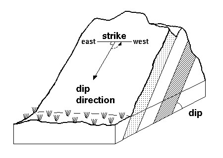
Any planar feature (in this case bedding planes) can be defined in space their “strike and dip”. Basically, it is the orientation of a geologic feature in space. The dip direction is taken at a right angle to the strike and is the steepest angle of a tilted bed (or feature) relative to a horizontal plane and is given by a number from 0 to 90 degrees as well as the rough direction (N, E, S, W) in which the bed is dipping. Therefor a dip of 90 degrees would be vertical. So the dip may be stated as “the beds are dipping 45 degrees to the north”.
Strike can be a bit more complicated. The “strike” is line that represents the intersection of a geologic feature (fault, bedding lane, etc.) with a horizontal plane and is always a compass direction exactly 90 degrees to the direction of dip. One way to maintain whether your strike is east or west is the “right hand rule”. Imagine your right hand (fingers together, thumb extended 90 degrees to your fingers) against the bedding plane with your fingers pointing down along the steepest angle of the tilted beds (the angle of dip). Your thumb points in the direction if strike. Strike can be stated as quadrant compass bearing (N 15˚W).
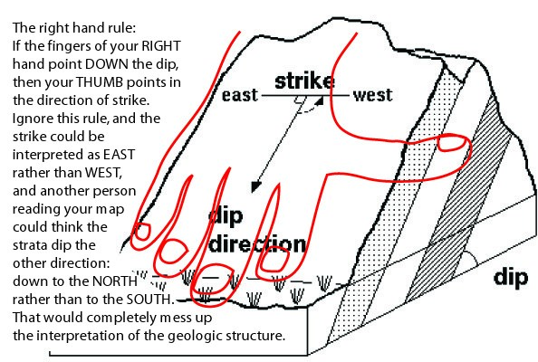
The easiest way to grasp this is visually, the diagram below represents the strike and dip of a typical folded sequence of sedimentary rocks.
 Along the trail you will see several exposures of folded sedimentary rocks where you can take a measurement of the strike and dip of the rock. To earn credit for this earthcache your job is to find an outcrop where you can identify an ice solid bedding place (rock bed surface) to measure the strike and dip and then email your answers. There are several ways to do this including the use of a compass and clinometer or even downloading a smartphone app for strike and dip. Geologists typically carry a Brunton compass which has a built inclinometer and is designed for this purpose. If you do not have a clinometer your GPS will provide the compass you need and you can make an educated guess as to the angle of dip. Please do not stress over being correct, we are looking to see that you read the material and gave it your best shot to try and make a measurement that a Geologist would use to map the geologic history of this area, we aren’t grading anyone. The idea is to introduce you to some local geology and most of all to have some fun on the trail. Although we read through everyone's answers on all of our EC's we are not able to respond to each one individually. We hope you enjoy this Earthcache and maybe even learn something new about the world around us.
Additional Hints
(No hints available.)