La Butte d'Aumont EarthCache
-
Difficulty:
-

-
Terrain:
-

Size:  (other)
Please note Use of geocaching.com services is subject to the terms and conditions
in our disclaimer.
Earthcache Type : Other Feature

FRANCAIS
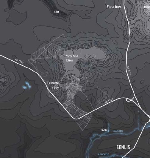
La butte d'Aumont en Halatte est une colline de sable à l'orée de la forêt, offrant un panorama sur les massifs forestiers de la région, ainsi que sur Montataire, Creil et la cathédrale de Senlis. Appendice du mont Alta, la butte s’en trouve séparée par un col assez profond, ce col étant une des entrées du village. Le plateau de la Butte d’Aumont est mesuré à 124m.
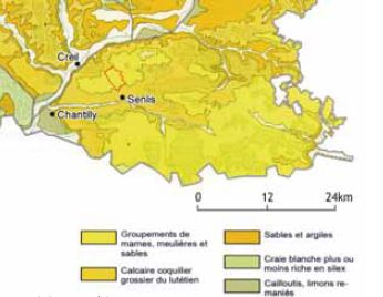
Le sable, est un matériau granulaire constitué de petites particules provenant de la désagrégation d'autres roches dont la dimension est comprise entre 1/16 de mm et 2 mm selon la définition des matériaux granulaires en géologie. Sa composition peut révéler jusqu'à 180 minéraux différents (quartz, micas, feldspaths) ainsi que des débris calcaires de coquillage et de corail.
Dès la fin du Moyen Âge jusqu'à 1800, la manufacture de Saint-Gobain prélevait environ 600 tonnes par an, chargés sur bateau à Creil. La butte a également servi à fabriquer de la porcelaines à Chantilly et de la faïence à Creil. L'exploitation a été arrêté pour éviter que la butte ne disparaisse.
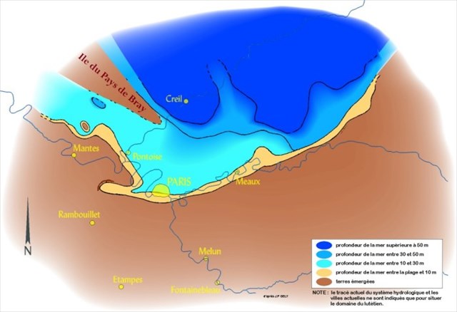
Au Lutétien, la forêt d'Halatte était sous l'eau, sous une profondeur de plus de 50m :
Pour valider la cache, envoyez-moi par mail les réponses aux questions suivantes. Vous pourrez loguer found-it une fois les réponses validées :
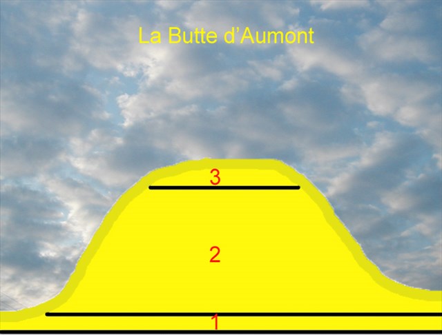
1- Décrivez de quoi est composée cette butte en complétant la coupe ci-après:
2-Au Waypoint 2, identifiez la roche que vous voyez et mesurez la (hauteur, largeur, profondeur depuis le sable).
3- Sachant que cette roche a une densité d'environ 2,68 kg/dm3, indiquez la masse du morceau de roche que vous observez.
4-Expliquez avec vos propres mots comment le sable de la butte s’est géologiquement retrouvé ici.
5-Tâche facultative, prenez une photo de vous aux coordonnées
ENGLISH
La Butte d'Aumont en Halatte is a hill on the edge of the forest, with panoramic views of the forests of the region, as well as Montataire, Creil and Senlis cathedral. Appendix of the Mont Alta, the hill is thereby separated by a fairly deep pass, this pass is one of the entrances to the village. The board of the Butte d'Aumont is measured 124m.
Sand, is a granular material consisting of small particles from the disintegration of rocks whose other dimension is between 1/16 mm to 2 mm depending on the definition of granular materials in geology. Its composition can be up to 180 different minerals (quartz, mica, feldspar) and limestone debris shell and coral.
;
From the late Middle Ages until 1800, the factory of Saint-Gobain levied approximately 600 tons per year, loaded on a ship in Creil. The mound was also used to make the Chantilly porcelain and earthenware in Creil. The operation was stopped to avoid the hump disappears.
Lutetian to the Halatte forest was under water, below a depth of more than 50m:
To validate the cache, send me by mail the answers of the following questions. You can log it as found when i will responde you:
1 - Describe what makes up this hill completing the cut below:
2-In Waypoint 2, identify the rock you see and measure it (height, width, depth from the sand).
3 - Knowing that this rock has a density of about 2.68 kg/dm3, indicate the mass of the piece of rock that you see.
4-Explain in your own words how the sand is found here.
5- Optional task, take a picture of you to contact

Additional Hints
(No hints available.)