 SVENSKA
Geologi
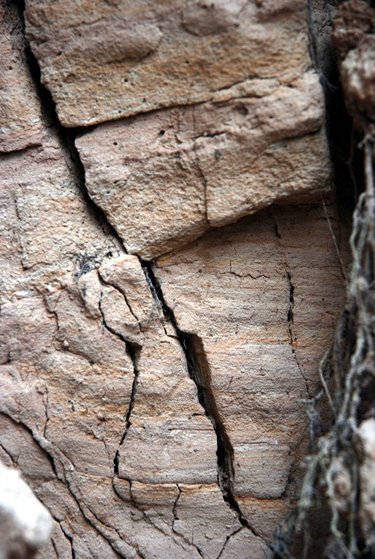
Naturreservatet Bullerdalen utgörs av den bäckravin som har skapats genom vattnets erosion i de mjuka sedimenten som utgör jordlagret här på platsen. Jorden består här av finkorningt material, lera (partikelstorlek mindre än 0.002 mm) upp till finmo (partikelstorlek 0.02-0.06 mm). På andra sidan Svartälven som bäcken rinner ut i består jordlagren av morän som är en osorterad blandning av allt ifrån fina lerpartiklar till större stenblock. Även Svartälven har ätit sig ner i jordlagren genom årtusendena sen den senaste istiden och där bäcken och älven möts har det bildats en hög och smal åsrygg på vars utsida jordlagren är fullt synliga. Studera dem gärna men var försiktiga om ni hänger över kanten, det är brant och rasrisken är stor.
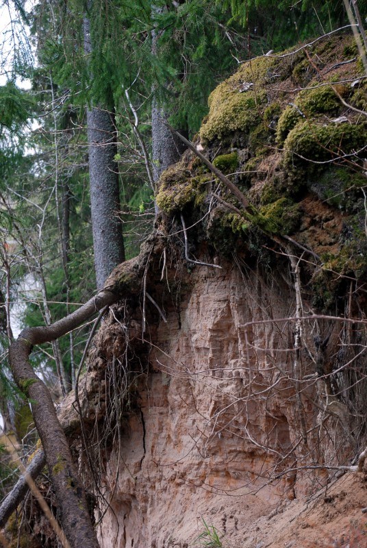
Sedimentlager vid referenspunkt 1
Sediment layers at reference point 1
Ibland, tex efter regnfall eller vid snösmältning när bäckens vattenflöde är större än vanligt syns erosionens effekt extra tydligt eftersom vattnet då blir brunfärgat av de jordpartiklar som vattnet för med sig. Då kan man även passa på att studera flödesdynamiken när det bruna vattnet från bäcken blandar sig med svartälvens klarare vatten.
Krökar och kurvor
När bäcken gör en krök så kommer vattnets hastighet att vara högre vid ytterradien än innerradien och detta gör att erosionen äter mer ur marken på yttersidan av kröken. Eftersom vattnets hastighet vid insidan av kröken är lägre gör att det material som transporteras av vattnet sjunker till botten och bildar nya sedimentlager. Av den orsaken är bäcken också djupare i ytterkurvorna än i innerkurvorna.
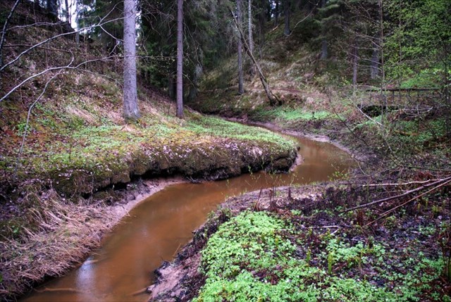
Bullerbäcken som slingrar sig ner mot Svartälven.
Bullerbäcken winding its way down to Svartälven.
Dessa fenomen gör tillsammans att krökarna blir större och större så att bäcken till slut "möter sig själv" varpå vattnet sen tar den genaste vägen och en så kallad korvsjö bildas av den gamla bäckfåran. Här i bullerdalen finns tyvärr inga korvsjöar, men krökar på bäcken finns det gott om! Krökar av det här slaget uppkommer oftast bara där landskapet är flackt, vilket märks även här. Bäckens kurvor och krökar är mest frekvent förekommande i dalens nedre del, i den övre delen där bäcken faller brantare slingrar den sig inte alls fram på samma tydliga sätt.
|
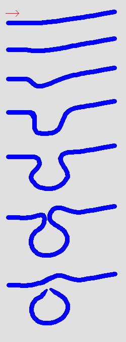
Bildandet av en korvsjö. Källa: Wikipedia
The formation of a oxbow lake. Source: Wikipedia
|
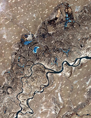
Satellitfoto av Song Hua-floden i Kina. Exempel på en flod med många kurvor, krökar och korvsjöar. Källa: Wikipedia
Satellite photo of the Song Hua-river in China. Example of a river with many curves, bends and ox-bow lakes. Source: Wikipedia
|
I naturreservatet växer förutom stor granskog även 14 arter av ormbunkar som färgar marken härligt grön sommartid. Bland annat finns här den meterhöga ormbunken Strutbräken.
Loggningskrav
För att logga denna Earthcache som "hittad" skall du även skicka svaren på följande frågor till cacheägaren, däremot behöver du inte invänta godkännande för att logga cachen. Behöver jag kompletterande uppgifter så hör jag av mig.
- Antag att det har tagit 8000 år att erodera ner ravinen till dagens djup, hur lång tid kommer det att ta (med samma erosionstakt) att göra den dubbelt så djup?
Det finns inget "rätt" svar, motivera dina antaganden och resultat
- På den södra sidan (referenspunkt 2) är det tydligt hur ravinen skär ner i det i övrigt väldigt platta landskapet. Beräkna hur länge kan du stå 10 cm från kanten innan marken eroderas bort under fötterna på dig? Anta att det har tagit 8000 år att skapa ravinen som den ser ut idag och att erosionen fortsätter i samma takt. Gör de mätningar (tex djup och bredd) du tycker behövs för dina beräkningar.
Det finns inget "rätt" svar, motivera dina antaganden och resultat.
- Vad kallas de kringelkrokar som bäcken gör nere i Bullerdalen?
- Raviner och kanjoner skapas båda av erosion från vatten. Vad är skillnaden mellan dem?
Frivillig (men uppskattad) bonusuppgift: ladda upp ett foto på dig själv stående i Bullerdalen.
 ENGLISH
Geology
The Nature Preserve Bullerdalen consists of the ravine which has been created by water erosion in the soft sediments which the soil consists of here on the site. The soil here consists of fine-grained material, clay (particle size less than 0.002 mm) up to silt (particle size 0.002 - 0.06 mm). On the opposite side of Svartälven, which the creek flows into, the soil consists of Till, which is unsorted glacial sediments with anything from clay particles to larger boulders. Svartälven has also eaten down in the soil through the millennia since the last ice age. Where the creek and river meet, a high, narrow ridge has formed and on the outside of the ridge (towards the river) the layers are clearly visible. Study them well but be careful if you are hanging over the edge, it is steep and the hazard of collapse is imminent.
Sometimes, eg after rainfall or snowmelt when the stream flow is bigger than usual, visible signs of the erosion is more evident because the water then becomes tan of the soil particles transported by the water. Then you can also take the opportunity to study the flow dynamics as the brown water from the stream mixes with the clearer water from the river.
Curves and bends
When the stream makes a turn, the velocity of the water will be higher at the outer radius than the inner radius and this makes the erosion eat out of the ground on the outside of the curve. As the velocity of the water at the inside of the bend is lower, the material being transported by the water drops to the bottom and will form new sediment layers. For this reason, the creek is also deeper in the outer curves than in the inner curves.
These phenomena together will extend the bends so they become larger and larger and the stream will eventually "meet itself" whereupon the water then takes the shortest route and a so-called oxbow lake is formed by the old brook. Here in the Bullerdalen there are unfortunately no oxbow lakes, but bends in the creek are plentiful! Curves of this type are more likely to occur only where the landscape is flat, which is also evident here. The stream's curves and bends are most frequent in the bottom of the valley, in the upper part where the stream falls more steeply it does not bend, wind and curve in the same manner.
Logging Requirements
To log this Earth Cache as "found", please send answers to the following questions to the cache owner. However, you do not need to wait for approval to log the cache, if I need additional information, I will contact you.
- Assume that it has taken 8,000 years to erode down the ravine to the current depth, how long it will take (with the same erosion rate) to make it twice as deep? There is not "correct" answer, just motivate your assumptions and results.
- On the south side of the ravine (reference point 2) it is very clear how the ravine has cut trough the otherwise flat landscape. Calculate for how long can you stand 10 cm from the edge without the ground having eroded away below your feet? Assume that it has taken 8,000 years to create the ravine as it looks today and that the erosion will contonue in the same pace. Make the measurements (i.e. width and depth) you need for your calculations.
There is no "correct" answer, just motivate your assumptions and results.
- What are the curves and bends called that the creek makes in Bullerdalen?
- Ravines and canyons are both created by erosion from water. What is the difference between them?
Optional (but appreciated) bonus task: upload a photo of yourself standing in Bullerdalen.