Older but Higher
The Ochils are made of volcanic rocks from the Lower Devonian period - that is around 410 million years ago. They comprise over 2000m of lava flows interbedded with volcanic mudflow conglomerates and some ash layers. These were all formed on the surface, one layer covering the last, building up this great thickness. The lavas range in composition from basaltic (basic) to andesitic (intermediate). The latter type is named after similar rocks in the Andes, forming from present day volcanoes.
The main vents, or roots of the Ochil volcanoes have not yet been found - they are probably buried deep down beneath the younger Carboniferous sediments of the plain. Dumyat at the western end of the range of hills, despite its shape, is NOT an extinct volcano. The only possible small volcanic neck so far recognised is now under water in the Upper Glendevon Reservoir.
Younger but Lower
The underlying rocks of the Forth and Devon valleys are of Carboniferous age. These are younger than the Ochils being formed around between 335-300 million years ago. They consist of sedimentary layers including mudstones, sandstones and coal measures, in a number of cyclical series. Beneath them lie more of the older Ochil Volcanic Formation. You cannot see the carboniferous rocks at GZ as they are overlain by recent carse clays.
Why?
A fault is a crack in the crust of the earth which has allowed relative movement of the rocks on either side. It is called a 'normal' fault if the descending block slips away as a result of extension forces.
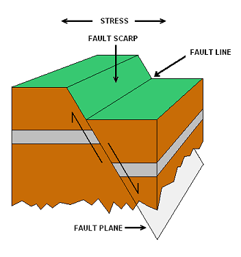
The Ochil fault must have been active from the earliest part of the Carboniferous period, moving periodically. It caused the rocks to its north to move upwards while those to the south moved down. Basins formed which filled with sediments before becoming marine swamps in which the coal-producing vegetation flourished before another movement inundated them again. The maximum vertical downthrow to the south, around 3000m, is just east of Alva. There are many other smaller faults in the valley too. They are mostly aligned roughly east-west or northwest-southeast, consistent with a north-south opening up of the Midland Valley as a whole. Displacement took place fairly soon in geological terms after the strata were deposited. Although there will have been later re-activity, there is only one record of definite movement in historical times - an earthquake in Dollar in 1736. Minor tremors felt in Menstrie, including one experienced by the cache owners in the late 1970s, have had their epicentres north of the Ochil Fault.
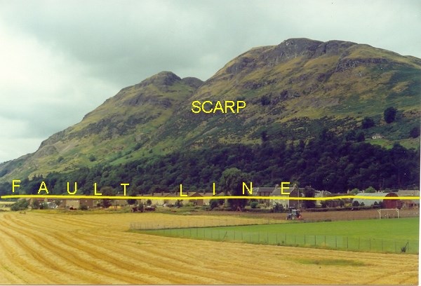 Dumyat as seen from Menstrie
What You See
When at GZ, in front of you is the impressive face of Craig Leith rising just over 500m above you (slightly to your right as you look north to the hills).
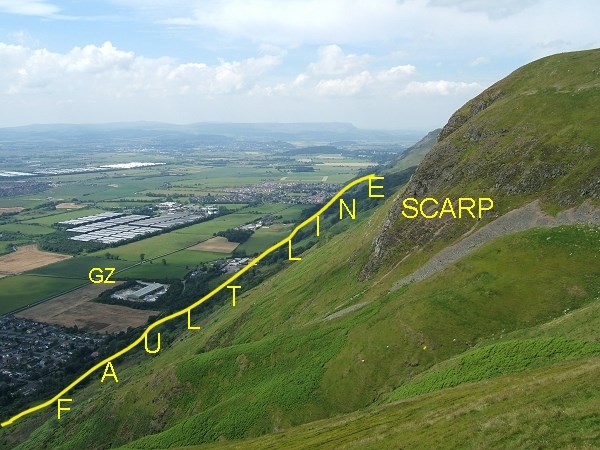 Craig Leith as seen from Wee Torry
Of course the Ochils were never 3000m high. As they rose to the north of the Fault, the equivalent rocks were sinking to the south - it is the relative movement which gives the downthrow. However, since the movement on the fault, the exposed rocks have been subject to the usual erosion agents of ice, wind and water which have reduced them to their present height. Ben Cleuch, the highest point, is only 721m. In fact the fault plane is even steeper than the slope we see now. Can you see the stepped nature of the slopes of the scarp? This is called trap formation. It is caused by differential weathering of the bedded lavas and pyroclastic flows.
To claim this earthcache:
To claim this earthcache please e-mail me the answers to the questions below. Do not put the answers in your log. You may log once you have done this.
1) Look towards Craig Leith. Briefly describe what you see from a geological point of view. Include the following terms in your description:
a) line of the Ochil Fault
b) scarp slope
c) Devonian volcanic rocks
d) carse clays overlying Carboniferous rocks .
* Make sure you mention the approximate direction of the line of the fault. *
2) From GZ how far west can you see along the Ochils scarp? How far east? You may use a map to answer in terms of the names of the hills, or the villages at the foot of the hills you can see, or you can estimate the distance in miles.
3) Is this the full length of the Fault? Can you explain what your answer tells us about the Fault?
Parking:
There is room for 3 cars at the given co-ordinates. Please do NOT block the track. There is no need to cross the busy A91 but do keep an eye on children.