Le Château de Pierre Percée - Buntsandstein EarthCache
Le Château de Pierre Percée - Buntsandstein
-
Difficulty:
-

-
Terrain:
-

Size:  (not chosen)
Please note Use of geocaching.com services is subject to the terms and conditions
in our disclaimer.
___________________________________________________________________________________________________________
FRENCH
___________________________________________________________________________________________________________
Le Château de Pierre Percée - Buntsandstein
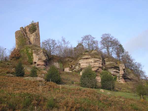
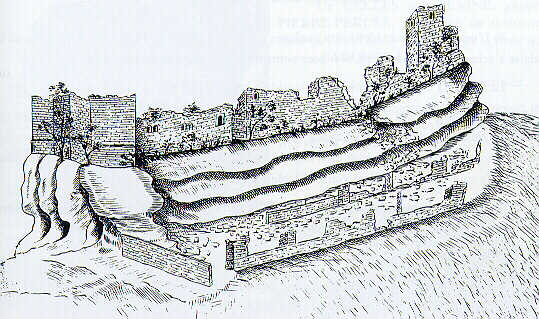
Le château de Pierre-Percée sont des ruines à 10 km à l’est de Badonviller, sur l'actuelle commune de Pierre-Percée, en Meurthe-et-Moselle.
Il a été bâti au Moyen Âge, ce château fait l’objet d’un classement au titre des monuments historiques depuis le 21 septembre 1981.
Le château avait été construit sur un imposant affleurement de roche en grès bigarré de 495m d'altitude.
Le grès bigarré - Buntsandstein
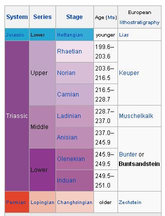
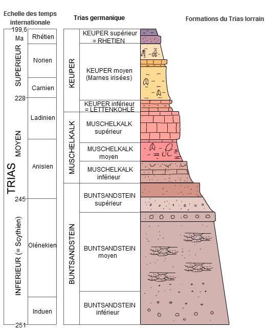
Le grès bigarré est l’étage stratigraphique inférieur du Trias aux premiers temps de l'ère secondaire tel qu'il s'exprime en Europe centrale et du nord-est.
Il a été défini originellement dès la publication des travaux géologiques de Friedrich von Alberti qui le décrit en 1834 sous le nom de Buntsandstein.
Ce mot géologique allemand est le produit de la contraction de bunter Sandstein, qui signifie grès coloré ou multicolore.
Le grès bigarré n'est que la simple traduction française dès 1835 de cette expression pour désigner la partie sédimentaire inférieure du trias lorrain ou germanique.
L'étage souvent composé de roches gréseuses rouges est encore appelé dans l'est de la France « trias vosgien ».
Ces couches de grès rouges plongent sous le bassin parisien, zone d'accumulation tertiaire, pour réapparaître aux confins occidentaux de la Normandie ou au sud de l'Angleterre.
Le grès bigarré caractérise la petite région naturelle de la Vôge.
Il existe aux abords des Massif vosgien des autres formations triasiques spécifiques généralement non décrites sous cette appellation.
Le terme grès bigarré est quelque peu trompeur, puisqu'il ne désigne pas vraiment un type de roche (un grès de différentes teintes), mais une formation géologique, épaisse souvent de plusieurs centaines de mètres, qui comporte surtout du grès.
C'est pourquoi on parlait autrefois souvent de « grès bigarré » (et, pour l'étage suivant, de calcaire coquillier ou Muschelkalk) pour désigner la formation géologique du Trias inférieur.
Or le grès bigarré s'interpose dans les strates de façon très différente d'un point à l'autre du globe et pour cette raison, il ne peut servir d’indicateur international pour la subdivision du Trias, et la limite entre le Trias inférieur et le Trias moyen, telle qu'elle est définie aujourd'hui, ne coïncide plus avec celle, trop élevée, du grès bigarré et du calcaire coquillier.
POUR LOGGUER CETTE EARTHCACHE vous devez répondre aux questions suivantes et m’envoyer les réponses par mail via mon profil :
1) A quelle époque géologique le grès biggaré s'est-il formé ? trias inférieur, moyen ou supérieur.
2) Citez une île Européenne reputée pour son impressionant piton gréseux (grès biggaré) ?
3) Estimez la hauteur en mètres de l'affleurement rocheux aux coordonnées de la cache (près du panneau) ?
4) Dans la première grotte aux coordonnées suivantes : N48°28.245,E006°55.876 cherchez sur la droite un galet incrusté dans le roche gréseuse marqué d'un "M" vert et donnez moi la taille de celui-ci ?
5) OPTIONNEL et NON OBLIGATOIRE : Faire une photo de vous ou de votre GPS sur le site et ajouter là à votre log.
INFORMATION : Profitez-en pour observer la vue depuis le château.
___________________________________________________________________________________________________________
ENGLISH
___________________________________________________________________________________________________________
The castle of Pierre-Percée - Buntsandstein
The castle of Pierre-Percée ruins are 10 km east of Badonviller on the current common Pierre Percee, Meurthe-et-Moselle.
It was built in the Middle Ages, this castle is the subject of a classification as historical monuments since 21 September 1981.
The castle was built on a massive outcrop of sandstone rock at 495m above sea level.
The bunter sandstone - Buntsandstein
The Buntsandstein (German for 'coloured sandstone') or Bunter sandstone is a lithostratigraphic and allostratigraphic unit (a sequence of rock strata) in the subsurface of large parts of west and central Europe.
The Buntsandstein predominantly consists of sandstone layers of the Lower Triassic series and is one of three characteristic Triassic units (together with the Muschelkalk and Keuper that form the Germanic Trias Supergroup).
The Buntsandstein is similar in age, facies and lithology with the Bunter of the British Isles.
In the past the name Buntsandstein was in Europe also used in a chronostratigraphic sense, as a subdivision of the Triassic system.
Among reasons to abandon this use was the discovery that its base lies actually in the latest Permian.
The Buntsandstein was deposited in the Germanic Basin, a large sedimentary basin that was the successor of the smaller Permian Basin and spread across present day Poland, Germany, Denmark, the southern regions of the North Sea and Baltic Sea, the Netherlands and south England.
In the late Permian this region had an arid climate and it was covered by inland seas which deposited the Zechstein evaporites.
At the end of the Permian a connection with the Paleo-Tethys Ocean to the south was formed in present day southeast Poland, causing sea water to flow in periodically.
This caused the inflow of more clastic material, which was deposited in the form of large alluvial fans.
Deposition took place in an arid, continental environment (playa facies), so that there was little chemical weathering.
Therefore the Bundsandstein deposits are typical red beds, mainly sandstones and conglomerates with little clay.
The late Anisian saw a major rise of the global (eustatic) sea level.
A tropical sea filled the Germanic Basin then, stopping the deposition of the Bantsandstein and marking the beginning of the deposition of the Muschelkalk.
HOW TO LOG THIS CACHE ?
You must answer to the next questions and send me your results by mail on my GC profil.
1) In which geologic period did the Bunter sandstone form ? Triassic upper, middle or lower.
2) Give me the name of an European island well known for its impressive Buntsandstein outcrop ?
3) At the exact coordinates of this cache make an estimation of the height of the outcrop in front of you? (close to the infoboard)
4) Inside the first cave at the coordinates : N48°28.245,E006°55.876 you'll find at your right a shingle (pebble) marked with a green "M", give me the size of this natural pebble inlayed into the bunter rock ?
5) OPTIONAL (NOT MANDATORY) : Take a picture of yourself or your GPS unit at the front of the site and attach it to your log.
INFORMATION : Enjoy the view from the top of the castle.
| I have earned GSA's highest level: |
 |
 |
Additional Hints
(Decrypt)
Or pnershy ng gur gbc bs gur pnfgyr / Fblrm cehqrag fhe yr puâgrnh