Puzzleinsel Usedom EarthCache
-
Difficulty:
-

-
Terrain:
-

Size:  (other)
Please note Use of geocaching.com services is subject to the terms and conditions
in our disclaimer.
Usedom ist ein geologisches Puzzle, zusammengesetzt aus verschiedenen Bestandteilen im Laufe von Jahrtausenden durch erdäußere (exogene) Kräfte.
Während der Lösung der Aufgaben zu diesem Earthcache werden einige wichtige Puzzleteile vorgestellt.
|
10.11.2023: Cachekontrolle - alle Puzzleteilinformationen sind aktuell vorhanden.
Usedom, mit 406 km⊃2; die zweitgrößte Insel Deutschlands, setzt sich geologisch gesehen aus verschiedenen Teilen zusammen, die in der jüngsten Vereisungsperiode und in den darauf folgenden Jahrtausenden entstanden.
Während der Weichselkaltzeit (Beginn: vor ca. 115.000 Jahren, Ende: vor 11.700 Jahren) kam es mehrfach durch Temperaturveränderungen zum Vorrücken und Abschmelzen der skandinavischen Inlandeisgletscher.
Letztmalig erreichten diese Gletscher das heutige Gebiet Deutschlands vor rund 15.000 Jahren. Sie schoben sich und mitgeführte Materialien aber nur noch bis in den heutigen Ostseeküstenraum vor und bildeten während längerer Stillstands- und Abschmelzphasen einen Endmoränenbogen von Rügen über Usedom bis Wollin.
|
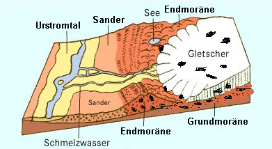
Die abschmelzenden mächtigen Inlandeismassen hinterließen im Zusammenwirken mit dem Wind und riesigen Schmelzwassermengen charakteristische Landschaftsformen.
Es sind dies die Grundmoränen, die Endmoränen, die Sander und die Urstromtäler (zusammengefasst als "Glaziale Serie" bezeichnet).
Der Golm ist eine besondere Art der Endmoräne, eine ???-endmoräne (schon abgelagertes Moränenmaterial wurde bei erneutem Vorrücken eines Gletscherteiles aufgepresst und ???) und war zu seiner Entstehungszeit sicherlich 200 - 300 m höher als heute. |
 |
Mit dem Abschmelzen stieg der Meeresspiegel stark an, so dass vor 7.000 - 5.000 Jahren nur die höchsten Erhebungen der Endmoränen als Inselkerne aus dem Wasser ragten.
In den folgenden Jahrtausenden wurden durch die Meeresbrandung, durch Regen und Wind die Endmoränen bis zu ihrer heutigen Höhe abgeflacht. Gleichzeitig setzte durch die fehlende Eisbelastung ein langsamer Hebeprozess des nordeuropäischen Tieflandes ein (Skandinavien und der nordöstliche Ostseeküstenbereich heben sich noch heute um mehrere Millimeter pro Jahr.).
Weitere "Puzzleteile" verbanden die Inselkerne miteinander und es entstand Usedom in seiner heutigen Form.
Um den Earthcache loggen zu können, sind die folgenden Fragen zu beantworten:
1. Wie heißt die Endmoränenart, die den Golm bildete?
2. Wodurch wurden die entstandenen Inselkerne in der postglazialen Zeit (Holozän) miteinander verbunden?
3. Vergleiche die Steigung von R1 zu R2 mit der Hangneigung am Aussichtspunkt Richtung Nordost. Nenne mögliche Ursachen für die Unterschiedlichkeit.
Sende die Antworten an unsere Profiladresse.
Es kann sofort geloggt werden. Falls etwas nicht stimmt, werden wir uns melden.
Viel Erfolg und allzeit Good Hunting! |
English version (Thank you, Bernd, for translation.)
Puzzle Island Usedom
Usedom is a geological puzzle, formed by various components during the thousands of years by "exogene" forces.
During the resolution of the tasks for this earth cache important puzzle elements are being introduced.
Usedom is the second largest island in Germany with 406 square meters. In geological terms it consists of various parts which were formed during the most recent ice age and in subsequent thousand of years.
During the "Weichsel" cold period (starting: before approx. 115,000 years, ending: before 11,700 years) there were numerous advances and melting of the Scandinavian inland glaciers (Gletscher) resulting from temperature changes.
Last time these glaciers reached the current territory of Germany approximately 15,000 years ago. With them they moved materials only to the current coastal area of the Baltic Sea and they created during longer periods of stagnation and melting a terminal moraine crescent from the island of Rügen across Usedom to "Wollin". |
The enormous melting masses of inland ice left behind landscape formations characteristic of concurrence of wind and huge amounts of melt water (Schmelzwasser). These are the bottom moraines (Grundmoränen), the terminal moraines (Endmoränen), the "Sander"(?) and the glacial valleys (summarized as "Glacial Series").
The "golm" is a special kind of terminal moraine, a ??? end-moraine (already stored moraine material was at renewed advancing of glacier material pressed on and???) and was at time of origin certainly 200 to 300 meters higher than today. |
 |
With melting, the sea level was rising drastically, so that 7000 to 5000 years ago only the highest peaks of the terminal moraines rose above sea level as island cores.
During following thousand of years the terminal moraines were leveled to current heights due to the force of the ocean, rain and wind. At the same time, resulting from the lack of ice pressure, a slow process of a rising of the North-European low lands occurred (Scandinavia and the north-eastern Baltic Sea coast to this date are still rising by several millimeters each year).
More "puzzle elements" connected the core of the islands with each other and so Usedom was formed in its today's shape.
To log the earth cache the following questions are to be answered:
1. What is the kind of terminal moraine called which forms the "Golm"?
2. How were the rising island cores of the post-glacial period (Holozän) connected with each other?
3. Compare the slope of R1 to R2 with the slope at the lookout northeast. Give possible reasons for the disparity.
Send replies to our profile address.
You can log-in immediately. If anything is wrong we will respond by return.
We wish much success and always Good Hunting! |
Additional Hints
(No hints available.)