
MORPHOGENESE DE L'AGGLOMERATION GRENOBLOISE :
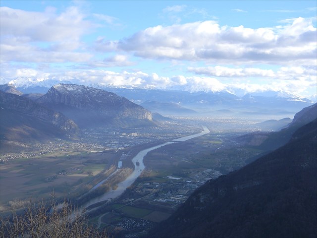
L’agglomération grenobloise s’est développée dans un site particulièrement contraignant :
une plaine d’environ 100 kilomètres carrés (équivalent à la taille de Paris intra-muros) au confluent décentré d’une rivière, l’Isère, et d’un gros torrent alpin qui, au Moyen Âge, débordait régulièrement dans la cuvette grenobloise, le Drac.
Cette plaine prenant la forme d'un Y est entourée de trois massifs montagneux, la Chartreuse, le Vercors et Belledonne, dont le premier avance un éperon jusqu’en ville, tandis que les deux autres rejoignent la plaine par des collines plus ou moins pentues. Cette configuration permet de parler d’une « cuvette grenobloise », vallée singulièrement plate d'origine glaciaire. La fonte du glacier de l'Isère, il y a environ 25 000 ans, entraîne la présence d'un lac pendant plus de 10 000 ans, avec ses alluvions lacustres de la dernère glaciation (le würm) qui confèrent aujourd'hui aux vallées, un caractère parfaitement plat.
L'écoulement de la glace iséroise se faisait d'Ouest en Est, en recevant l'appoint des glaces du Drac par le Sud de l'Y grenoblois, pour s'engager dans l'étroit goulot d'étranglement de la trouée ("cluse") de l'Isère, en direction de Voreppe.
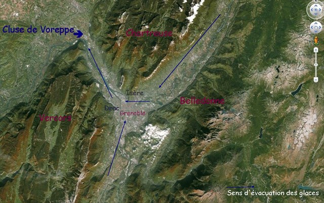
Les sondages ont même révélé que le bedrock (= fond rocheux) de la vallée se trouvait à plus de 200 m sous le sol actuel (c'est-à-dire en dessous du niveau de la mer).
CONTEXTE GEOLOGIQUE DE LA CUVETTE GRENOBLOISE :
Le bassin grenoblois est caractérisé par une couverture sédimentaire postglaciaire d'importante épaisseur (atteignant 900m au centre de l'agglomération).
Ces dépôts sont constitués de matériaux argileux, de sables et de graviers.
Il existe donc un fort contraste d'impédance entre ces matériaux et le socle rocheux sur lequel ils reposent.
Le champ d'onde incident lors de tremblements de terre est alors piégé dans les formations superficielles et subit de multiples réverbérations :
il en résulte un phénomène d'amplification du mouvement sismique appelé "effet de site".
L'amplification des vibrations sismiques est liée à la nature géologique du sol et à la géométrie en cuvette en forme de Y du bassin de Grenoble.
Tout comme Annecy ou Chambéry, la ville est construite au coeur d'une vallée creusée par les glaciers et remplie de sédiments (sables, argiles, graviers) beaucoup plus souples que le rocher sous-jacent.
Bien que située dans une région sismiquement très calme comparée à la Californie, au Japon, ou même à la Grèce,
Grenoble n'est pas à l'abri d'un séisme de magnitude 5,5 à proximité de la ville, du type de celui de Corrençon ou d'Annecy.
Et l'on sait, grâce au réseau sismologique de surveillance Sismalp, que la faille dite de « Belledonne » est active.
Par ailleurs, l'analyse géologique indique que d'autres failles pourraient produire un séisme sous la ville.
MESURE DE L'AFFAISSEMENT ACTUEL DE LA CUVETTE GRENOBLOISE :
La cluse de l’Isère et du bas-Grésivaudan sont sujets à un affaissement de 1 à 2 mm/an sur plus d’un siècle.
Des études scientifiques tentent de déterminer les raisons et la signification de cet affaissement
(effondrement tectonique lié à une extension Nord-Est / Sud-Ouest ?, tassement des alluvions profondes et/ou superficielles ?),
Des mesures effectuées sur Grenoble et une partie de sa banlieue en 2002 ont montré des zones d’affaissement atteignant 3 à 5 mm/an sur près de 30 ans.
Pour valider cette cache, envoyez moi un mail via mon profil avec les réponses aux questions suivantes :
1 ) Pour preuve de votre présence sur les lieux :
Il y a une table d'orientation aux coordonnées indiquées de la cache.
- Quelle est l'altitude mentionnée juste à côté de la boussole ?
- De quelle église est-il fait mention en haut à gauche de la table ?
(NE METTEZ PAS DE PHOTO DE LA TABLE OU D'INFORMATION DANS VOTRE LOG !!! )
2 ) Questions relatives à la Cuvette Grenobloise (toutes les réponses sont dans le texte et les images ! ) :
A - Quels sont les massifs qui donnent la forme d'un "Y" à l'agglomération grenobloise ?
B - Par où s'évacuèrent les glaces il y a 25 000 ans ?
C - Quels matériaux y a-t-il entre la surface de la cuvette et le bedrock ?
3) Dessinez la cuvette grenobloise, avec montagnes, rivières, immeubles,... ! amusez-vous et postez là dans votre log.
Tout log déposé sans mon autorisation, donnée après la validation de vos réponses par mail, sera supprimé.
ATTENTION :
-
AUCUNE PHOTO OBLIGATOIRE , mais toute illustration est toujours bienvenue !
-
PAS DE PHOTO DE LA TABLE D'ORIENTATION
-
FAITES NOUS UN BEAU DESSIN !!!!!

MORPHOGENESE OF THE GRENOBLE URBAN DISTRICT :
The Grenoble urban district developed in a particularly binding site:
A plain about 100 square kilometers (equivalent to the size of Inner Paris) in the confluence moved away from the center by a river, Isère, and by a big alpine torrent which, in the Middle Ages, overflowed regularly in the basin from Grenoble, the Drac.
This plain taking the shape of one Y is surrounded with three mountain massifs, the Chartreuse, the Vercors and Belledonne, whose first one moves forward a spur up to city, whereas two others join the plain by more or less sloping hills. This configuration allows to speak about a " basin of Grenoble ", a strangely flat valley of glacial origin. The cast iron of the glacier of Isère, approximately 25 000 years ago, entails the presence of a lake during more than 10 000 years, with its lakeside alluviums of the last glaciation which confer on valleys today, a perfectly flat character.
.
The flow of Isère ice was made from west to east, by receiving the supplement of the ices of Drac by the south of the Y of Grenoble, to make a commitment in the narrow bottleneck of the pierced ("water gap") of Isère, in the direction of Voreppe.
The soundings even revealed that the bedrock (= rocky bottom) of the valley was in more than 200 m under the current ground (that is below the sea level).
GEOLOGIC CONTEXT OF THE BASIN OF GRENOBLE :
The pond from Grenoble is characterized by a postglacial sedimentary cover of important thickness (achieving 900m in the center of the urban area).
These deposits are constituted by clayey materials, by sands and by gravels.
There is thus a strong contrast of impedance between these materials and the bedrock on wich they base.
The incidental field of wave during earthquakes is then trapped in the superficial formations and undergoes multiple reverberations:
It results from it a phenomenon of development of the seismic called movement " effect of site ".
The development of the seismic vibrations is bound to the geologic nature of the ground and the geometry in basin in the shape of Y of Grenoble.
Quite as Annecy or Chambéry, the city is built at the heart of a valley dug by the glaciers and filled with sediments (sands, clays, gravels) much more flexible than the underlying rock.
Although situated in a region seismicly very quiet compared in California, in Japan, or even in Greece, Grenoble is not shielded from an earthquake of magnitude 5,5 near the city, of the type of that of Corrençon or Annecy.
And we know, thanks to the seismological network of surveillance Sismalp, that the break said about "Belledonne" is active.
Besides, the geologic analysis indicates that the other breaks could produce an earthquake under the city.
MEASURE OF THE CURRENT COLLAPSE OF THE BASIN FROM GRENOBLE:
The water gap of Isère and bottom-Grésivaudan are subject to a collapse from 1 to 2 mm / year over more than a century.
Scientific studies try to determine the reasons and the meaning of this collapse, (Tectonic collapse bound to an extension NE-SW?, Collapse of the deep and/or superficial alluviums?),
Measures made on Grenoble and part of its suburb in 2002 showed zones of reaching collapse 3 in 5 mm / year over about 30 years.
To validate this cache, send me an e-mail via my profile with the answers to the following questions:
1.) For proof of your presence on the spot :
There is a viewpoint indicator in coordinates indicated by the cache.
· What is the height mentioned just next to the compass?
· Of what church is made upper left mention of the table?
(DO NOT PUT A PHOTO OF THE VIEWPOINT INDICATOR OR INFORMATION IN YOUR LOG !!!)
2.) Questions relative to the basin of Grenoble (all the answers are in the text and the images !):
A - What are the massifs which give the shape of a "Y" to the Grenoble urban district?
B - By where evacuated ices 25 000 years ago?
C - What materials is there between the surface of the basin and the bedrock?
3.) Draw the basin of Grenoble, with mountains, rivers, buildings... ! as you want, and post in your log there.
Logs without the required e-mail will be deleted!
So you must log after my permission.
WARNING :
-
NO OBLIGATORY PHOTO, but any illustration is always welcome!
-
NO PHOTO OF THE VIEWPOINT INDICATOR
-
MAKE US A BEAUTIFUL DRAWING !!!!!