To complete this challenge all you have to do is find a total of 221 different caches; how difficult can that be?
The cache is at the published location which is close to the centre of the Explorer 221 map.
What is the Explorer 221 Challenge?
 |
The cache is called the Explorer 221 Challenge because each of the 221 different caches you need to have found to qualify must be in a different British Ordnance Survey grid square as depicted on the Explorer 221 Coventry & Warwick map. |
| The caches can be of any type, previous finds qualify (including those finds now archived and events attended (even if you were the host)), in fact just about any cache other than those you have placed yourself (more on that later) can be counted. |
To find out more about this and other Explorer Challenge caches, go to www.pppgeo.co.uk/explorer.html which has been created to complement the cache series. |
 |
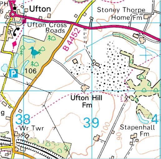
The grids on the map "start" in the north west corner near Coleshill at SP 20000 90000 |
| and "finish" to the south east of Ufton at SP 40000 60000, so giving a possible thirty (60 to 90) northing squares and twenty (20 to 40) easting squares. Thats 600 squares in total in which you need to find a cache in 221 different squares to qualify, which in turn equates to 37% of the possible squares available. |
 |
It can be time consuming trying to determine which of 600 squares of an OS map a cache qualifies for, although of course the British Grid reference is given at the top of each cache page just below the main co-ordinates shown in bold, as circled below.
|
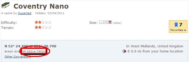 |
For the purposes of this challenge the published co-ordinates of all caches, including Unknown/Mystery and Multi caches are those that are to be used when determining which square a cache counts towards
To help those of you that want to plan your finds a GSAK Macro has been written which produces a web page of your finds. For example, the macro run on my finds produces the output shown below and demonstrates that I would qualify for this cache.

When you have found the 221 caches you need to provide proof of that fact to be eligible to claim a find on the cache; this can be via one of any number of different methods you may have available:
- List the 221 cache codes and names and corresponding grid references in your found log
- Create a public bookmark list
- Create a Spreadsheet grid of your finds and attach an image of it to your log
- Attach the generated GSAK Macro image to your log
Any finds without proof of qualification will of course be deleted! Have fun!
Many thanks to PetersfieldPoodlePosse for allowing me to use the Explorer Challenge concept and writing the GSAK macro.